
Overview: The Path of Truth
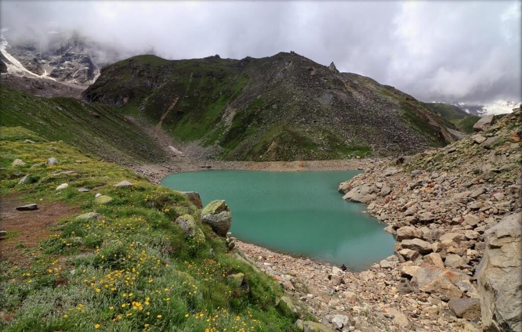
Hidden deep within the Garhwal Himalayas, at a breathtaking altitude of 4,600 metres (15,100 feet) above sea level, lies Satopanth Tal — one of Uttarakhand’s most sacred and least-crowded high-altitude lakes. Cradled between the towering peaks of Chaukhamba, Neelkanth, Swargarohini, and Balakun, this crystal-clear, emerald-green triangular glacial lake is not merely a trekking destination—it is a journey into the heart of Hindu mythology.
The name Satopanth is derived from Sanskrit: Sat (truth) + Panth (path)—meaning “The Path of Truth”. According to Hindu legend, the three corners of this triangular lake mark the meditation spots of the Holy Trinity—Brahma, Vishnu, and Mahesh (Shiva). It is also believed that the Pandavas of the Mahabharata passed through this sacred valley on their final journey to heaven via the Swargarohini glacier.
The trek begins at Mana Village—India’s last inhabited village before the Indo-Tibetan border—just 3 km from the Badrinath shrine. The trail passes through Bhim Pul (a natural rock bridge over the Saraswati River), the spectacular Vasudhara waterfall, and Laxmivan—a dense sacred forest—before ascending across glacial moraines and boulder terrain to the hidden lake.
What makes Satopanth Tal truly special is the approach: the lake remains invisible until the very last moment, then suddenly reveals itself in full—a moment of pure, indescribable awe. For those who make it, the solitude, the spirituality, and the scenery are unmatched anywhere in Uttarakhand.
Key Information at a Glance
History and Mythology of Satopanth Tal
The Divine Trinity
According to Hindu mythology, the Holy Trinity—Lord Brahma, Lord Vishnu, and Lord Shiva—descend to Earth on auspicious days to take a dip in the sacred waters of Satopanth Tal and meditate here. This is why the lake is triangular in shape—each corner represents one of the three deities. On every Ekadashi, the Trinity stands at the three corners of the lake and takes a holy bath. Lord Narayana is believed to ascend daily to Satopanth Tal to take a dip in the afternoon.
The Pandava Connection
Satopanth Tal is mentioned in the Mahabharata’s Swargarohan Parva. According to legend, the five Pandava brothers, along with Draupadi and a dog, passed through the Satopanth valley on their way to the heavens—a journey known as the Swargarohini Yatra. It is believed that Bhima, one of the Pandava brothers, left his body near Satopanth Tal. He was the last person to leave his body on earth while ascending to heaven. The route from Mana village to Satopanth Tal is therefore considered the sacred “path to heaven”.
The Gandharvas and the Sacred Birds
Locals believe that the birds living around Satopanth Tal are none other than Gandharvas—celestial beings disguised—who guard the lake against evils. These birds are said to clean the lake of any unwanted litter left behind by visiting devotees. The local belief is that only those with true devotion can cover the entire Satopanth valley and reach the lake.
A Living Spiritual Heritage
The lake is considered so sacred that residents of Mana village throw the ashes of the dead into the lake. Many saints have eulogised the lake and the surrounding area as being highly charged with spiritual currents of ancient yogis and seers. Devotees believe that a holy dip in Satopanth Tal washes away sins, and wishes made here are believed to be fulfilled.
Geography of Satopanth Tal
Location and Topography
Satopanth Tal is located in the Chamoli district of Uttarakhand, in the Garhwal Himalayas, near the pilgrimage town of Badrinath. The lake is situated at an altitude of 4,600 metres (15,100 feet) above sea level.
| Feature | Details |
|---|---|
| Coordinates | 30°44′37″N, 79°21′25″E |
| Altitude | 4,600 m (15,100 ft) |
| Shape | Triangular |
| Lake Type | Glacial lake |
| Nearest Village | Mana (18 km from Badrinath) |
The Surrounding Peaks
Several majestic peaks are visible en route and from the lake itself:
- Mt. Neelkanth
- Mt. Chaukhamba
- Mt. Swargarohini
- Mt. Balakun
- Mt. Parvati
- Kuber Top
The Satopanth Glacier
The lake is fed by the Satopanth Glacier, which also gives the lake its name. Trekkers wake up at the Chakratirtha campsite to an unobstructed view of the Satopanth Glacier, with Swargarohini and Chaukhamba dominating the horizon.
Flora and Fauna of Satopanth Tal
Flora — High-Altitude Ecology
The region surrounding Satopanth Tal is characterised by sparse high-altitude vegetation, with unique cold-adapted flora. The trail passes through:
- Dense oak and deodar forests in the lower reaches
- Alpine meadows with scattered wildflowers
- Glacial moraines with lichens and mosses
The valley is full of mesmerising scenery filled with rich flora, waterfalls, and ridges.
Fauna — Rare Himalayan Wildlife
The Satopanth region is home to some of the rarest high-altitude wildlife species:
| Species | Status |
|---|---|
| Snow Leopard (Uncia uncia) | Rare and elusive |
| Brown Bear (Ursus arctos) | Rare |
| Musk Deer (Moschus chrysogaster) | Endangered |
| Himalayan Tahr | Found at higher altitudes |
| Bharal (Blue Sheep) | Common in alpine zones |
Birdlife:
- Himalayan Monal — the state bird of Uttarakhand
- Golden Eagle
- Himalayan Griffon Vulture
- Gandharva Birds — believed to be celestial beings guarding the lake
Religious Beliefs and Significance
The Sacred Triangular Lake
Satopanth Tal is considered one of the most sacred lakes in Hinduism. Its triangular shape is believed to represent the three corners where Brahma, Vishnu, and Mahesh (Shiva) meditate. The lake’s water never freezes despite being at such a high altitude, and it is so crystal clear that you can see the bottom.
The Pandava Connection
The Satopanth Swargarohini Yatra is the pilgrimage route taken by devotees to pay their respects to the Pancha Pandavas and to witness the doorway to heaven—the Swargarohini Steps. According to legend:
The Ekadashi Ritual
On every Ekadashi, it is believed that the Holy Trinity bathes in the lake, standing separately on the three sides of this triangular lake. Lord Narayana is also believed to ascend daily to the lake to take a dip in the afternoon.
The Path of Truth
The name “Satopanth” itself—meaning “The Path of Truth”—reflects the belief that only those with true devotion and purity of heart can successfully complete this sacred journey.
Local Practices
Residents of Mana village throw the ashes of the dead into the lake, believing it to be a sacred resting place for departed souls.
How to Reach Satopanth Tal
Step 1: Reach Badrinath / Mana Village
By Air — Nearest Airports
| Airport | Distance | Details |
|---|---|---|
| Jolly Grant Airport, Dehradun | ~300 km to Badrinath | Nearest airport; connected to Delhi |
From Dehradun Airport:
By Train — Nearest Railway Stations
| Station | Distance | Details |
|---|---|---|
| Haridwar Railway Station | ~310 km to Badrinath | Well-connected to Delhi and other cities |
| Rishikesh Railway Station | ~300 km to Badrinath | Alternative station |
From Haridwar/Rishikesh:
- Hire a taxi or take a bus to Badrinath
- Buses start from Haridwar between 4 and 5 AM, taking around 13 to 14 hours to reach Badrinath
By Road (Most Popular)
| Route | Distance | Travel Time |
|---|---|---|
| Delhi → Badrinath | ~520 km | 14–16 hours |
| Rishikesh → Badrinath | ~300 km | 11–12 hours |
| Haridwar → Badrinath | ~310 km | 12–13 hours |
Route from Delhi:
Delhi → Haridwar → Rishikesh → Devprayag → Rudraprayag → Karnaprayag → Nandprayag → Joshimath → Badrinath → Mana
Important Note: The last ATM is at Joshimath before Badrinath. Carry sufficient cash for the entire trek.
Step 2: The Satopanth Tal Trek
The trek begins from Mana Village—India’s last inhabited village before the Indo-Tibetan border, just 3 km from Badrinath.
Trek Route Overview
Detailed Itinerary (7 Days / 6 Nights)
Key Landmarks on the Trail
- Mana Village: The starting point; India’s last inhabited village
- Bhim Pul: A natural rock bridge over the Saraswati River
- Vasudhara Falls: A spectacular 122-metre waterfall
- Laxmivan: A dense sacred forest
- Chakratirtha: A picturesque campsite with panoramic views
- Satopanth Tal: The ultimate destination
Trek Difficulty and Preparation
The Satopanth Tal trek is classified as moderate to difficult. Prior high-altitude trekking experience is strongly recommended.
Key Challenges:
- High Altitude: 4,600 metres; risk of Acute Mountain Sickness (AMS)
- Terrain: Glacial moraines, loose boulders, and steep ascents
- Remote: No shops or shelters along the way
- Weather: Can be extremely cold; temperatures drop to -5°C to -12°C at night
- Oxygen: Low oxygen content from Mana to Satopanth Tal
Preparation Tips:
- Start only with proper fitness and preparation
- Acclimatise well at Badrinath and Joshimath before the trek
- Carry enough water and dry food
- Take a local guide for safety
- Stay aware of altitude sickness symptoms
Distance from Major Cities
Weather and Best Time to Visit
Climate Overview
Satopanth Tal experiences an alpine climate with extreme temperature variations. The lake remains under snow from the end of September to the middle of May, sometimes until the end of June.
Seasonal Breakdown
Best Time to Visit by Season
Why Visit in Summer (May–June)
- Clear trails and accessible routes
- Pleasant daytime temperatures
- The lake is free of snow
- Ideal for first-time high-altitude trekkers
Why Visit in Autumn (September–October)
- Crystal-clear skies offering the best views of the Himalayan peaks
- Post-monsoon freshness
- Comfortable trekking conditions
- Perfect for photography
Why to Avoid Monsoon (July–August)
- Heavy rainfall makes trails slippery and dangerous
- High risk of landslides
- Reduced visibility
Why to Avoid Winter (November–April)
- Heavy snowfall makes the route inaccessible
- Extreme cold (temperatures can drop to -36°C)
- The lake remains frozen
Packing Guide
| Category | Items |
|---|---|
| Clothing | Heavy woollens, thermal wear, insulated jacket, fleece, raincoat, comfortable trekking pants |
| Footwear | Sturdy waterproof trekking shoes, warm socks, gaiters (for snow) |
| Accessories | Gloves, woolen cap, scarf, sunglasses, sunscreen |
| Gear | Backpack (50–60L), sleeping bag (-10°C rating), trekking poles, headlamp |
| Essentials | Water bottle, water purifier, snacks (energy bars, dry fruits), personal medication |
| Medical | Diamox for altitude sickness prevention, basic first-aid kit |
| Documents | Valid ID proof |
Nearby Places to Visit
Things to Do at Satopanth Tal
1. Trek to the Sacred Lake
The primary activity is the trek itself—a journey through breathtaking landscapes, sacred forests, and ancient legends to reach the triangular lake of the Holy Trinity.
2. Pay Homage at the Lake
Offer prayers at the sacred lake, believed to be the bathing spot of Brahma, Vishnu, and Shiva. Many devotees take a holy dip in its sanctifying waters.
3. Witness the Pandava Path
Walk the same path believed to have been traversed by the Pandavas on their final journey to heaven. Visit the spots where Nakula and Bhima left their bodies.
4. Photography
From the triangular emerald-green lake to the towering peaks of Chaukhamba, Neelkanth, and Swargarohini, Satopanth Tal offers endless photography opportunities.
5. Camping at Chakratirtha
Experience the breathtaking view of the Satopanth glacier with Swargarohini and Chaukhamba dominating the horizon.
6. Visit Vasudhara Falls
Make a pit stop at the spectacular 122-metre waterfall, known for its unusual nature of waters.
7. Explore Mana Village
Visit India’s last inhabited village before the Indo-Tibetan border and explore its unique Bhotiya culture.
8. Attend the Mata Murti Temple
Visit the mini temple dedicated to Mata Murti, the mother of Lord Narayana.
9. Stargazing
With no light pollution at 4,600 metres, the night skies offer spectacular stargazing opportunities.
Accommodation Options
| Type | Location | Features | Price Range |
|---|---|---|---|
| Hotels/Guesthouses | Badrinath | Basic amenities, comfortable stay | ₹1,500 – ₹5,000 |
| Camps | Laxmivan, Chakratirtha | Tents with basic facilities | Included in trek package |
| Forest Rest Houses | Mana | Basic accommodation | ₹500 – ₹1,500 |
| Dharamshalas | Badrinath | Simple pilgrim accommodation | ₹300 – ₹800 |
Travel Tip: Book accommodation well in advance, especially during peak season (May–June and September–October). Most trek packages include camping during the trek.
Local Cuisine — A Taste of Garhwal
The Satopanth Tal trek offers simple, nutritious meals designed for high-altitude trekking.
Must-Try Garhwali Dishes
| Dish | Description |
|---|---|
| Kafuli | Traditional spinach and fenugreek curry |
| Phanu | Lentil-based dish, a Garhwali speciality |
| Gahat ka Shorba | Nutritious soup made from horse gram |
| Mandua Roti | Finger millet flatbread |
| Jhangora Kheer | Sweet pudding made from barnyard millet |
Where to Eat
- Trek Packages: Most trek packages include all meals during the trek
- Hotels in Badrinath: Simple vegetarian meals
- Local Dhabas: Available in Badrinath and Joshimath
Frequently Asked Questions (FAQs)
General Questions
Q1: Where is Satopanth Tal located?
Satopanth Tal is located near Badrinath in the Chamoli district of Uttarakhand, at an altitude of 4,600 metres (15,100 feet) above sea level.
Q2: What is the altitude of Satopanth Tal?
Satopanth Tal is situated at an elevation of approximately 4,600 metres (15,100 feet) above sea level.
Q3: What is the best time to visit Satopanth Tal?
The best time to visit is from May to June and September to October when the weather is pleasant, and the trails are accessible.
Q4: How long is the Satopanth Tal trek?
The trek is approximately 22 km one-way from Mana Village, with a round trip of about 48 km. It typically takes 6 to 8 days to complete.
Q5: Is the Satopanth Tal trek difficult?
Yes, it is a high-altitude, difficult trek. Prior high-altitude trekking experience is strongly recommended.
Q6: Is there an entry fee for Satopanth Tal?
Q7: What is the significance of Satopanth Tal’s triangular shape?
The three corners of the triangular lake are believed to be the meditation spots of the Holy Trinity—Brahma, Vishnu, and Mahesh (Shiva).
Q8: What is the meaning of “Satopanth”?
Satopanth comes from Sanskrit: Sat (truth) + Panth (path)—meaning “The Path of Truth”.
Q9: What is the Pandava connection to Satopanth Tal?
According to the Mahabharata, the five Pandava brothers and Draupadi passed through this valley on their final journey to heaven via the Swargarohini glacier.
Q10: What animals can I see at Satopanth Tal?
The region is home to snow leopards, brown bears, musk deer, Himalayan tahrs, and bharals (blue sheep).
Q11: Does the lake freeze in winter?
The lake remains under snow from the end of September to the middle of May, sometimes until the end of June.
Q12: Is mobile connectivity available on the trek?
Mobile connectivity is available only at Badrinath and Mana. There is no network on the trail.
Q13: Are there ATMs near the trek?
The last ATM is at Joshimath (before Badrinath). Carry sufficient cash.
Travel Logistics
Q14: How can I reach Satopanth Tal from Delhi?
You can reach by:
- Road: Delhi → Haridwar → Rishikesh → Badrinath → Mana (~520 km, 14–16 hours)
- Train: Take a train to Haridwar or Rishikesh, then taxi/bus to Badrinath
- Air: Fly to Jolly Grant Airport, Dehradun, then taxi to Badrinath (11–12 hours)
Q15: What is the nearest railway station to Satopanth Tal?
The nearest railway stations are Haridwar and Rishikesh.
Q16: What is the nearest airport to Satopanth Tal?
The nearest airport is Jolly Grant Airport, Dehradun.
Q17: Do I need a guide for the Satopanth Tal trek?
A guide is highly recommended for safety, as the terrain is remote and challenging. Most trekking agencies include guides in their packages.
Q18: What should I pack for the Satopanth Tal trek?
Pack heavy woollens, thermal wear, an insulated jacket, sturdy waterproof trekking shoes, a sleeping bag, trekking poles, a headlamp, a water bottle, snacks, personal medication, and Diamox for altitude sickness prevention.
Practical Information
Q19: Is Satopanth Tal accessible during the monsoon?
It is not recommended to visit during the monsoon (July–August) due to heavy rainfall and the risk of landslides.
Q20: What is the water temperature of Satopanth Tal?
Despite being at such a high altitude, the water of the sacred lake never freezes and is crystal clear.
Q21: What are the Gandharva birds?
Locals believe that the birds living around Satopanth Tal are Gandharvas—celestial beings disguised—who guard the lake against evils and clean the lake of any litter.
Q22: How can I book a Satopanth Tal trek?
Trek packages can be booked through:
- Local tour operators in Rishikesh, Haridwar, and Joshimath
- Trekking agencies specialising in high-altitude treks
- Discover Uttarakhand for customised trekking packages
Q23: Is camping allowed at Satopanth Tal?
Camping is allowed at designated sites like Chakratirtha and Laxmivan as part of organised treks.
Q24: What is the difficulty level of the Satopanth Tal trek?
The trek is rated moderate to difficult. It is suitable for experienced trekkers with good fitness levels.
Plan Your Satopanth Tal Journey with Discover Uttarakhand
At Discover Uttarakhand, we’ve been organising unforgettable Himalayan journeys since 1997. As a trusted local operator with deep knowledge of the Garhwal region and its sacred sites, we offer:
✅ Customised Satopanth Tal trek packages (6 to 9 days)
✅ Combined itineraries covering Satopanth Tal, Badrinath, Mana Village, and Joshimath
✅ Experienced local guides and porters
✅ Comfortable transport with experienced hill drivers
✅ All necessary permits and arrangements
✅ Quality camping equipment and nutritious meals
✅ 24/7 customer support throughout your journey
Recommended Satopanth Tal Packages
| Package | Duration | Starting Point | Highlights |
|---|---|---|---|
| Satopanth Tal Trek | 6 Nights / 7 Days | Rishikesh | Badrinath, Mana Village, Laxmivan, Chakratirtha, Satopanth Tal |
| Satopanth & Swargarohini Yatra | 7 Nights / 8 Days | Haridwar | Satopanth Tal, Swargarohini views, Pandava path |
| Garhwal Sacred Lakes Trek | 8 Nights / 9 Days | Rishikesh | Satopanth Tal, Vasudhara Falls, Mana Village |
📞 Call / WhatsApp: +91-9997187178, 9760222178, 8171977178
📍 Visit Our Office: Himalayan Colony, opposite DSVV, Haripur Kalan, Haridwar, Motichur Range, Uttarakhand 249411
🌐 Website: www.discover-uttarakhand.com
📧 Email: info@discover-uttarakhand.com
Discover Uttarakhand – Your Local Partner for Unforgettable Himalayan Journeys Since 1997 🏔️