Introduction: Standing at India’s Edge
Hidden deep in the Garhwal Himalayas of Uttarakhand’s Chamoli district, Niti Valley is one of India’s most remote and breathtakingly beautiful destinations. Located at an altitude of approximately 3,600 meters (11,800 feet), this pristine valley lies close to the Indo-Tibetan border and is home to Niti Village—the last inhabited settlement of India in Garhwal.
Unlike the crowded tourist circuits of Mussoorie or Nainital, Niti Valley offers a raw, untouched Himalayan experience. Here, stone houses with prayer flags flutter against snow-capped peaks, the Dhauliganga River carves deep gorges through ancient mountains, and the Bhotiya community preserves traditions that have survived for centuries.
The valley’s history is as dramatic as its landscapes. Before the 1962 Sino-Indian War, the Niti Pass was a vital trade route between India and Tibet, with traders carrying salt, wool, and herbs across the high passes. Today, the border remains sealed, but the valley has opened to a new kind of traveller—those seeking adventure, culture, and the unique experience of standing at the very edge of India.
Whether you are a trekker looking for high-altitude trails, a cultural traveller wanting to experience Bhotiya village life, a pilgrim seeking the mystical Timmersain Mahadev Cave Temple (often called “Chhota Amarnath”), or simply someone who wants to drive one of India’s most scenic mountain roads, Niti Valley promises an unforgettable journey.
Key Information at a Glance:
History: From Ancient Trade Route to Sealed Border
The Niti Pass and the Indo-Tibetan Trade
Niti Valley’s history is inseparable from the Niti Pass, a high-altitude pass that once connected India with Tibet. Before the 1960s, this pass was a bustling trade route where merchants carried wool, salt, livestock, and herbs across the Himalayas. The valley was part of a larger network of Himalayan trade that sustained communities on both sides of the border.
The name “Niti” is derived from a Sanskrit word meaning “moral values,” reflecting the ancient trading practices and cultural exchanges that took place here.
The 1962 Sino-Indian War and Its Aftermath
The valley’s fate changed dramatically after the 1962 Sino-Indian War. The Niti Pass was sealed, and the border has remained closed since. The area became a strategically sensitive military zone, and the ancient trade routes fell silent.
Today, the Indian Army and Indo-Tibetan Border Police (ITBP) maintain a strong presence in the valley, and entry is regulated through permits. This military presence has helped preserve the valley’s pristine character—unchecked tourism development has been kept at bay.
Life in the Valley Today
Life in Niti Valley is challenging but deeply rooted in tradition. The Bhotiya community follows a semi-nomadic lifestyle: during the harsh winter months (November to April), when temperatures plummet well below freezing and heavy snowfall blocks access, the villagers migrate to lower altitudes. In the summer, they return to cultivate crops like barley, potatoes, and buckwheat.
This seasonal migration has been practised for generations, and it reflects the resilience of the people who call this remote valley home.
Recognition as a Tourism Village
In recent years, the Uttarakhand government has recognised the valley’s potential for offbeat tourism. While development remains minimal to preserve the area’s character, basic facilities for travellers have been established, and the valley is increasingly featured in travel guides for those seeking authentic Himalayan experiences.
Geography and Location
Geographic Coordinates
- Latitude: Approximately 30.92° N
- Longitude: Approximately 79.66° E
- Elevation: 3,600 meters (11,800 ft)
Location
Niti Valley is situated in the Chamoli district of Uttarakhand, in the Garhwal region of the Himalayas. The valley lies approximately:
- 85–90 km from Joshimath
- 24–26 km from the Indo-Tibet border (Niti Pass)
- 320 km from Dehradun
- 550 km from Delhi
Topography
The valley follows the course of the Dhauliganga River, which carves deep gorges through the Himalayan landscape. The terrain is characterised by:
- Rugged mountain slopes with steep inclines
- Alpine meadows (bugyals) at higher elevations
- Glacial river valleys with dramatic rock formations
- Dense forests of deodar, pine, and rhododendron at lower elevations
The valley is part of the Nanda Devi Biosphere Reserve, a UNESCO World Heritage Site known for its exceptional biodiversity.
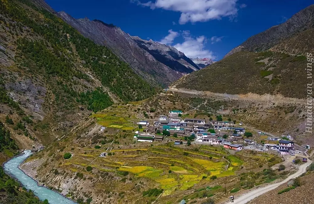
Villages of Niti Valley
The Niti Valley is dotted with several traditional Himalayan settlements, each with its own character and charm.
Niti Village – The Last Village of India
Niti Village is the crown jewel of the valley—the final inhabited settlement before the Indo-Tibet border. This is the place that travellers come to see: a cluster of stone houses with slate roofs, prayer flags fluttering in the thin mountain air, and the constant sound of the Dhauliganga River below.
What to Expect:
- Traditional Bhotiya architecture
- A small population (fewer than 50 families during the summer)
- Prayer flags and Buddhist-influenced cultural elements
- The starting point for the trek to Timmersain Mahadev Cave
- A sign marked “India’s Last Village”
Life in Niti: The village is inhabited only during the summer months (May–October). In winter, residents migrate to lower altitudes, leaving the village empty under a blanket of snow.
Gamshali Village – The Panoramic Viewpoint
Gamshali is one of the highest villages in the valley, located at approximately 3,350–3,600 meters. It offers breathtaking panoramic views of the surrounding Himalayan peaks and serves as the starting point for the Gamshali Bugyal trek.
What to Expect:
- Stunning mountain views
- Traditional Bhotiya homes
- Access to alpine meadows
- A quieter, less-visited alternative to Niti Village
Malari Village – The Historic Trading Post
Malari was historically a major trading settlement along the Indo-Tibetan route. Today, it is one of the most scenic villages in the valley, surrounded by towering peaks and river valleys.
What to Expect:
- Wooden architecture reflecting Indo-Tibetan influence
- Beautiful photographic opportunities
- A popular stop for travellers heading to the Upper Niti Valley
Top Attractions in Niti Valley
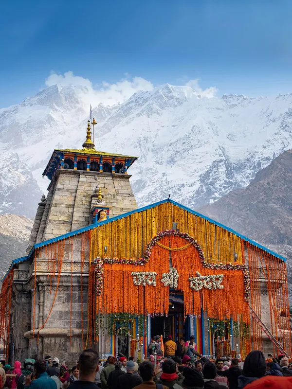
1. Timmersain Mahadev Cave Temple – The Chhota Amarnath
Timmersain Mahadev Cave Temple (also spelt Timarsain or Timmersen) is the most sacred site in Niti Valley and a hidden gem of Himalayan spirituality. Located on Timmarsain Mountain, approximately 700 meters from the main road and requiring a 2 km climb, this cave temple houses a natural ice Shivling that forms during winter.
Why It’s Called Chhota Amarnath:
The natural ice formation resembles the famous ice Shivling of the Amarnath Cave in Kashmir, leading locals and devotees to call it “Chhota Amarnath” (Little Amarnath). In winter, the Shivling grows to about 10 feet higher than its usual size, and water dripping from the cave ceiling keeps it smeared with water.
The Legend:
According to local belief, this is the place where Lord Shiva is said to reside in his icy form. ITBP soldiers stationed in the region do not move further without paying homage at this revered site.
Visiting Information:
Note: The temple is open from March to October, but the ice Shivling is best seen in March and April before it melts.
2. Gamshali Bugyal – The Alpine Meadow Trek
Gamshali Bugyal is a stunning alpine meadow located above Gamshali Village. The trek offers some of the most breathtaking views in the entire Niti Valley.
| Aspect | Details |
|---|---|
| Trek Distance | 6 km (one way) |
| Altitude Gain | 3,350 m → 3,600 m (11,000–11,300 ft) |
| Difficulty | Easy to Moderate |
| Best Time | May–June, September–October |
What to Expect:
- Vast green meadows surrounded by snow-capped peaks
- Wildflowers bloom during the summer
- Stunning photographic opportunities
- A sense of complete isolation from the modern world
3. Niti Pass Viewpoint
While the Niti Pass itself is a restricted zone due to its proximity to the border, permitted visitors can explore nearby viewpoints offering stunning high-altitude scenery.
What to Expect:
- Views of the Indo-Tibet border region
- Dramatic mountain landscapes
- A sense of standing at India’s edge
Important: Full access to Niti Pass is restricted. Permits only allow visits to designated viewpoints.
4. Dronagiri Village – The Ramayana Connection
Dronagiri Village is linked to the Ramayana legend of the Sanjeevani herb. According to the epic, Lord Hanuman flew to the Dronagiri mountain to fetch the life-saving herb for Lakshmana. The village sits amidst dramatic mountain landscapes and offers a glimpse into local mythology and culture.
What to Expect:
- Stunning mountain views
- Cultural connection to the Ramayana
- A peaceful, offbeat destination
5. Tapovan – The Hot Springs
Located on the way from Joshimath to Niti Valley, Tapovan is known for its hot water springs. It makes an excellent stop before entering the valley, allowing travellers to relax and soak in the warm waters after the long drive.
Location: Approximately 14 km from Joshimath
Best For: Relaxation, spiritual atmosphere
6. Dhauliganga River Valley
The Dhauliganga River flows through Niti Valley, creating deep gorges, dramatic waterfalls, and stunning landscapes. The river is a constant companion throughout the journey from Joshimath to Niti Village.
Activities:
- Landscape photography
- Nature exploration
- Trekking along river routes
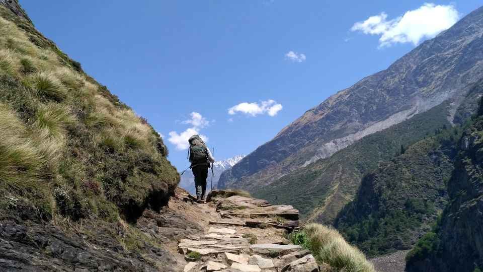
Trekking in Niti Valley
Niti Valley is a paradise for trekkers, offering routes for various skill levels.
Gamshali Bugyal Trek – Detailed Information
The trek to Gamshali Bugyal is the most popular in the valley and is suitable for beginners and experienced trekkers alike.
Trail Description:
- The trek starts from Gamshali Village
- The path climbs steadily through alpine terrain
- Stone houses and farm fields gradually disappear
- You emerge into vast green meadows surrounded by peaks
What to Carry:
- Sturdy trekking shoes
- Water and snacks
- Warm layers (even in summer, the meadows can be windy)
- Camera
Best Time: May–June (flowers in bloom), September–October (clear skies)
Bhotiya Culture and Lifestyle
The Rongpa People
The inhabitants of Niti Valley belong to the Bhotiya community, specifically the Marchha and Tolccha clans. They are of Mongoloid origin and are known as Rongpa—a term that reflects their ancient roots in the Himalayan region.
Language
The language spoken by the Marchas is a mix of Tibetan and Garhwali, while the Tolcchas speak Garhwali Rongpa. This linguistic blend reflects the valley’s position at the crossroads of Indian and Tibetan cultures.
Traditional Lifestyle
- Seasonal Migration: Villagers migrate to lower altitudes during winter (November–April) and return in summer for cultivation
- Farming: Crops include barley, potatoes, and buckwheat
- Livestock: Yak and sheep herding
- Wool Weaving: Traditional handicrafts, including shawls and carpets
Food
The Bhotiya cuisine reflects Tibetan influences:
Handicrafts
The women of the community are skilled weavers, producing:
- Woollen shawls and blankets
- Traditional carpets
- Woollen caps and mufflers
These handicrafts can be purchased directly from the villagers—a meaningful way to support the local economy.
How to Reach Niti Valley
By Air
Nearest Airport: Jolly Grant Airport, Dehradun (approximately 320 km from Niti Valley)
| Details | Information |
|---|---|
| Distance | ~320 km |
| Travel Time | 10–12 hours by taxi to Joshimath |
| Airlines | Regular flights from Delhi to Dehradun (approx. 1 hour) |
| Onward Travel | Taxi from airport to Joshimath, then local transport to Niti Valley |
By Train
Nearest Railway Station: Rishikesh (approximately 310 km from Niti Valley)
| Station | Distance | Travel Time | Connectivity |
|---|---|---|---|
| Rishikesh | ~310 km | 9–10 hours by road | Most preferred |
| Haridwar | ~300 km | 9–10 hours by road | Major station, well-connected |
Popular Trains from Delhi to Haridwar/Rishikesh:
| Train Name | From Delhi | Departure | Arrival | Destination |
|---|---|---|---|---|
| Shatabdi Express | Delhi | 6:00 AM | 11:40 AM | Haridwar |
| Jan Shatabdi | Delhi | 3:20 PM | 9:00 PM | Haridwar |
| Mussoorie Express | Delhi | 10:05 PM | 5:30 AM | Haridwar |
From the railway station, taxis and buses are available for Joshimath.
By Road
Niti Valley is reached via Joshimath, which is well-connected to major cities:
| Starting Point | Distance to Joshimath | Travel Time |
|---|---|---|
| Delhi | ~500 km | 14–16 hours |
| Rishikesh | 250 km | 9–10 hours |
| Haridwar | 270 km | 9–10 hours |
| Dehradun | 270 km | 9–10 hours |
Step-by-Step Route to Niti Valley
Step 1: Reach Joshimath
Joshimath is the base town for the Niti Valley trip. It is accessible by taxi or bus from Rishikesh/Haridwar/Dehradun.
Step 2: Joshimath to Niti Village (85–90 km)
From Joshimath, you must travel by private vehicle or local taxi to Niti Village.
Route: Joshimath → Tapovan → Malari → Gamshali → Niti
Travel Time: 4–5 hours
Road Condition: Mountain roads maintained by BRO (Border Roads Organisation)
Important Notes:
- 4×4 vehicle is recommended for the rough mountain terrain
- Carry extra fuel as there are no petrol pumps beyond Joshimath
- Start early (by 7:00–8:00 AM) to complete the journey in daylight
Distances from Major Cities
Niti Valley Permit Information
Since Niti Valley is a border area near the Indo-Tibetan frontier, permits are mandatory for visitors.
Who Needs a Permit?
| Nationality | Permit Required? | Notes |
|---|---|---|
| Indian Citizens | Yes (Inner Line Permit) | Required for visiting Niti Village |
| Foreign Nationals | Generally restricted | Should confirm current rules before planning |
How to Get the Permit
- Issuing Authority: SDM Office, Joshimath
- Documents Required: Valid government ID (Aadhaar Card, Voter ID, Passport)
- Vehicle Details: Required for vehicle permit
- Permit Fee: Approximately ₹150 per person + ₹250 per vehicle
- Processing Time: Usually a few hours; apply a day in advance if possible
Important Notes
- Permits are usually issued for a day visit or a limited stay
- Carry the permit with you at all times during the trip
- The permit is checked at multiple checkpoints
- Do not attempt to travel beyond Niti Village without additional authorisation
Important Note on Niti Pass
While the valley is accessible with a permit, Niti Pass (the actual border crossing) remains restricted for civilians. Only army personnel and the ITBP have access beyond certain points.
Weather and Best Time to Visit
Climate Overview
Niti Valley experiences a harsh alpine climate. Due to its high altitude, winters are extremely cold with heavy snowfall, and the valley is inaccessible for several months.
Month-by-Month Guide
Best Time to Visit by Season
Why Visit in Summer (May–June)
- Roads are fully open and accessible
- Pleasant daytime temperatures
- The valley is green and lush
- Villagers are present, offering cultural experiences
- Timmersain Mahadev is accessible
Why Visit in Post-Monsoon (September–October)
- Crystal-clear skies offer stunning mountain views
- Fewer tourists than in peak summer
- Fresh greenery after the rains
- Ideal for photography
Timmersain Mahadev Darshan Season
The best time for darshan of the ice Shivling at Timmersain Mahadev is March to mid-April, when the ice formation is at its peak. However, the road to Niti Valley may still be opening in March. Plan accordingly and check road conditions before travelling.
Accommodation Options
Accommodation in Niti Valley is limited and basic due to its remote location.
In Niti Valley
In Joshimath (Recommended Base)
Most travellers prefer to stay in Joshimath and make a day trip to Niti Valley due to the limited facilities in the valley.
| Category | Price Range (per night) | Features |
|---|---|---|
| Mid-Range Hotels | ₹2,500 – ₹5,000 | Comfortable rooms, hot water, good food |
| Budget Hotels | ₹800 – ₹2,000 | Basic amenities, affordable |
| Homestays | ₹1,500 – ₹3,500 | Authentic Garhwali experience |
| Dharamshalas | ₹500 – ₹1,500 | Simple, spiritual atmosphere |
Booking Tips
- Book well in advance for the summer season (May–June)
- Homestays in Niti Valley must be arranged through local contacts or tour operators
- Carry warm clothing—even in summer, nights can be very cold
- Carry cash—card facilities are not available in the valley
Sample Itinerary
4-Day Niti Valley Explorer (From Rishikesh)
Day 1: Rishikesh to Joshimath
- Morning: Depart from Rishikesh early (by 6:00 AM)
- En route: Visit Devprayag, Rudraprayag, and Karnaprayag (Panch Prayags)
- Afternoon: Arrive in Joshimath, check into the hotel
- Evening: Explore Joshimath town, visit Narasimha Temple
- Night: Overnight in Joshimath
Day 2: Joshimath to Gamshali/Niti Valley
- Morning: Early departure to Niti Valley (85 km, 4–5 hours)
- En route: Stop at Tapovan (hot springs), Malari Village
- Afternoon: Arrive at Gamshali, check into homestay
- Evening: Explore Gamshali Village, sunset views
- Night: Overnight in Gamshali
Day 3: Niti Village & Timmersain Mahadev
- Morning: Drive to Niti Village (the last village of India)
- Late Morning: Climb to Timmersain Mahadev Cave Temple (2 km, 45–60 min)
- Afternoon: Darshan of the ice Shivling, explore the cave
- Late Afternoon: Return to Gamshali or Joshimath
- Night: Overnight in Gamshali/Joshimath
Day 4: Return to Rishikesh
- Morning: Depart from Niti Valley
- Afternoon: Arrive in Rishikesh (9–10 hours)
- Evening: Depart for onward journey
5-Day Niti Valley with Gamshali Bugyal Trek
Day 1: Rishikesh → Joshimath (drive)
Day 2: Joshimath → Gamshali, explore village
Day 3: Gamshali Bugyal trek (6 km one way), overnight in Gamshali
Day 4: Gamshali → Niti Village → Timmersain Mahadev → return to Joshimath
Day 5: Joshimath → Rishikesh
Travel Tips and Important Information
Before You Go
- Check Weather: Avoid monsoon (July–August) due to landslide risk
- Obtain Permits: Inner Line Permit is mandatory for Niti Village; obtain from the SDM Office in Joshimath
- Carry Cash: No ATMs beyond Joshimath; bring sufficient cash
- Fill Fuel: Last petrol pump in Joshimath; fill your tank before proceeding
- 4×4 Vehicle Recommended: The roads beyond Joshimath are rough and require a sturdy vehicle
- Carry Warm Clothing: Even in summer, nights can be very cold; winter requires heavy woollens
- Advance Booking: Essential for accommodations during the summer season
During Your Visit
- Start Early: Begin your journey to Niti Valley by 7:00–8:00 AM to complete the drive in daylight
- Stay Hydrated: Carry water for the drive and treks
- Respect Military Presence: The area is sensitive; follow instructions from army/ITBP personnel
- Respect Local Customs: The Bhotiya community has unique traditions; be respectful and ask permission before photographing people
- Carry Snacks: Food options are very limited beyond Joshimath
Safety Tips
- Road Safety: Mountain roads are narrow and winding; avoid night driving
- Monsoon Travel: Avoid July–August due to landslide risk
- Altitude Awareness: At 3,600 m, altitude sickness is possible; stay hydrated and take it easy
- Emergency Numbers: Keep local contacts handy (Joshimath SDM, police)
Packing Checklist
| Season | Essentials |
|---|---|
| All Year | Sturdy walking/trekking shoes, warm jacket (even in summer), sunscreen, sunglasses, hat, reusable water bottle, power bank, camera, cash, ID proof, permit copies |
| Summer (May-Jun) | Light layers for daytime, heavy woollens for nights, a raincoat (pre-monsoon) |
| Post-Monsoon (Sep-Oct) | Light layers for daytime, heavy woollens for nights, raincoat (pre-monsoon) |
| Monsoon (Jul-Aug) | Raincoat, waterproof footwear (avoid travel if possible) |
Photography Tips
- Best Spots: Niti Village (last village sign), Dhauliganga River valley, Gamshali Bugyal meadows, Timmersain Mahadev viewpoint
- Best Time: Early morning for clear mountain views; late afternoon for golden hour shots
- Camera Gear: Carry extra batteries—cold drains them quickly
- Note: Ask permission before photographing locals and military installations
Nearby Places to Visit
Frequently Asked Questions (FAQs)
Q1: Why is Niti Valley famous?
A: Niti Valley is famous for being home to Niti Village—the last inhabited village of India near the Indo-Tibet border. It is also known for the Timmersain Mahadev Cave Temple (Chhota Amarnath), its stunning high-altitude landscapes, and the traditional Bhotiya culture.
Q2: What is the best time to visit Niti Valley?
A: The best time to visit is May to June (summer) and September to October (post-monsoon). The valley remains closed from November to April due to heavy snowfall.
Q3: How far is Niti Valley from Delhi?
A: The distance from Delhi is approximately 550 km, with a travel time of 14–16 hours by road.
Q4: Do I need a permit to visit Niti Valley?
A: Yes, Indian citizens need an Inner Line Permit (ILP) to visit Niti Village. Permits are issued at the SDM Office in Joshimath.
Q5: Can foreigners visit Niti Valley?
A: Foreign nationals have restricted access to Niti Valley due to its proximity to the Indo-Tibet border. Current rules should be confirmed before planning a trip.
Q6: What is the altitude of Niti Valley?
A: Niti Valley is situated at an altitude of approximately 3,600 meters (11,800 feet) above sea level.
Q7: What is Timmersain Mahadev?
A: Timmersain Mahadev is a cave temple where a natural ice Shivling forms during winter. It is often called “Chhota Amarnath” (Little Amarnath).
Q8: What is the Gamshali Bugyal trek?
A: The Gamshali Bugyal trek is a 6 km (one-way) trek from Gamshali Village to a stunning alpine meadow at approximately 3,600 meters. It offers panoramic Himalayan views.
Q9: Is there accommodation in Niti Valley?
A: Accommodation is limited and basic—homestays and guesthouses are available in Gamshali and Malari villages. Most travellers prefer to stay in Joshimath.
Q10: What is the road condition to Niti Valley?
A: The roads are maintained by BRO, but are narrow and winding. A 4×4 vehicle is recommended for the rough mountain terrain.
Q11: Are there ATMs in Niti Valley?
A: No, there are no ATMs beyond Joshimath. Carry sufficient cash before proceeding.
Q12: Is a mobile network available in Niti Valley?
A: Mobile connectivity is very weak or unavailable in most parts of the valley. Inform family of your travel plans in advance.
Q13: What is the Timmersain Mahadev darshan season?
A: The ice Shivling is best seen from March to mid-April. However, road conditions in March can be challenging. The temple is accessible from March to October.
Q14: Is Niti Valley suitable for senior citizens?
A: The high altitude (3,600 m), rough roads, and limited facilities may be challenging. However, the main village area itself does not require extensive walking.
Q15: What is the history of Niti Pass?
A: Niti Pass was an ancient trade route between India and Tibet that was sealed after the 1962 Sino-Indian War. The border remains closed to civilian crossings.
Plan Your Niti Valley Journey with Discover Uttarakhand
At Discover Uttarakhand, we’ve been organising unforgettable journeys across Devbhoomi since 1997. As a trusted local operator with deep knowledge of the Garhwal region and its remote border valleys, we offer:
- ✅ Customised Niti Valley tour packages (4 to 7 days)
- ✅ Combined itineraries covering Niti Valley, Joshimath, Badrinath, and Auli
- ✅ Complete permit assistance (Inner Line Permit processing)
- ✅ Comfortable transport with experienced hill drivers and 4×4 vehicles
- ✅ Verified accommodations in Joshimath and homestays in Niti Valley
- ✅ Trekking arrangements with local guides
- ✅ 24/7 customer support throughout your journey
Recommended Niti Valley Packages
| Package | Duration | Starting Point | Highlights |
|---|---|---|---|
| Niti Valley Explorer | 3 Nights / 4 Days | Rishikesh | Joshimath, Gamshali, Niti Village |
| Niti Valley with Timmersain Darshan | 4 Nights / 5 Days | Rishikesh | Joshimath, Gamshali, Niti Village, Timmersain Cave |
| Niti Valley & Gamshali Bugyal Trek | 5 Nights / 6 Days | Rishikesh | Joshimath, Gamshali, Bugyal trek, Niti Village |
| Complete Border Valley Tour | 6 Nights / 7 Days | Delhi | Rishikesh, Joshimath, Niti Valley, Badrinath |
Book your Niti Valley journey today and stand at the very edge of India, where the Himalayas touch the sky and ancient traditions live on.
📞 Call / WhatsApp: +91-9997187178, 9760222178, 8171977178
📍 Visit Our Office: Himalayan Colony, opposite DSVV, Haripur Kalan, Haridwar, Motichur Range, Uttarakhand 249411
🌐 Website: www.discover-uttarakhand.com
📧 Email: info@discover-uttarakhand.com
Jai Niti Valley! Har Har Mahadev! 🙏
Discover Uttarakhand – Your Local Partner for Unforgettable Himalayan Journeys Since 1997