Overview: The Abode of Gods
Tucked away in the heart of the Garhwal Himalayas, Chamoli is not just a destination; it is a journey into the soul of the mountains and the spiritual heart of India.
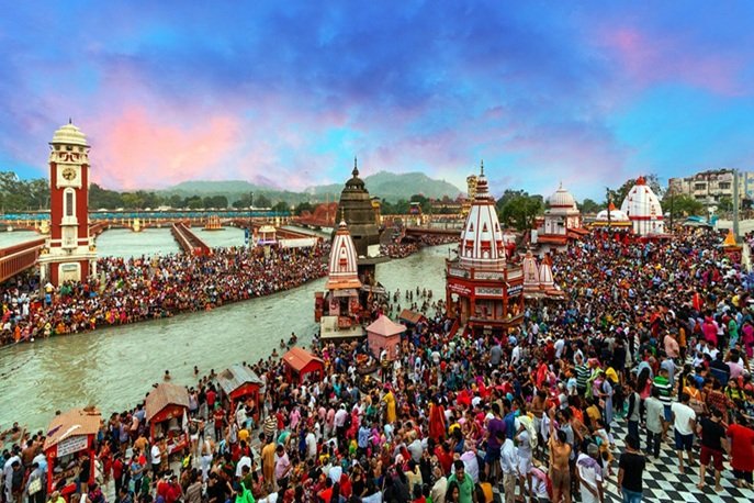
Often referred to as the “Abode of Gods”, this magnificent district is a land of unparalleled natural beauty and profound spiritual significance. Located in the Garhwal division of Uttarakhand, Chamoli is home to some of the most sacred pilgrimage sites in Hinduism, including the world-famous Badrinath Temple and the Panch Kedar temples.
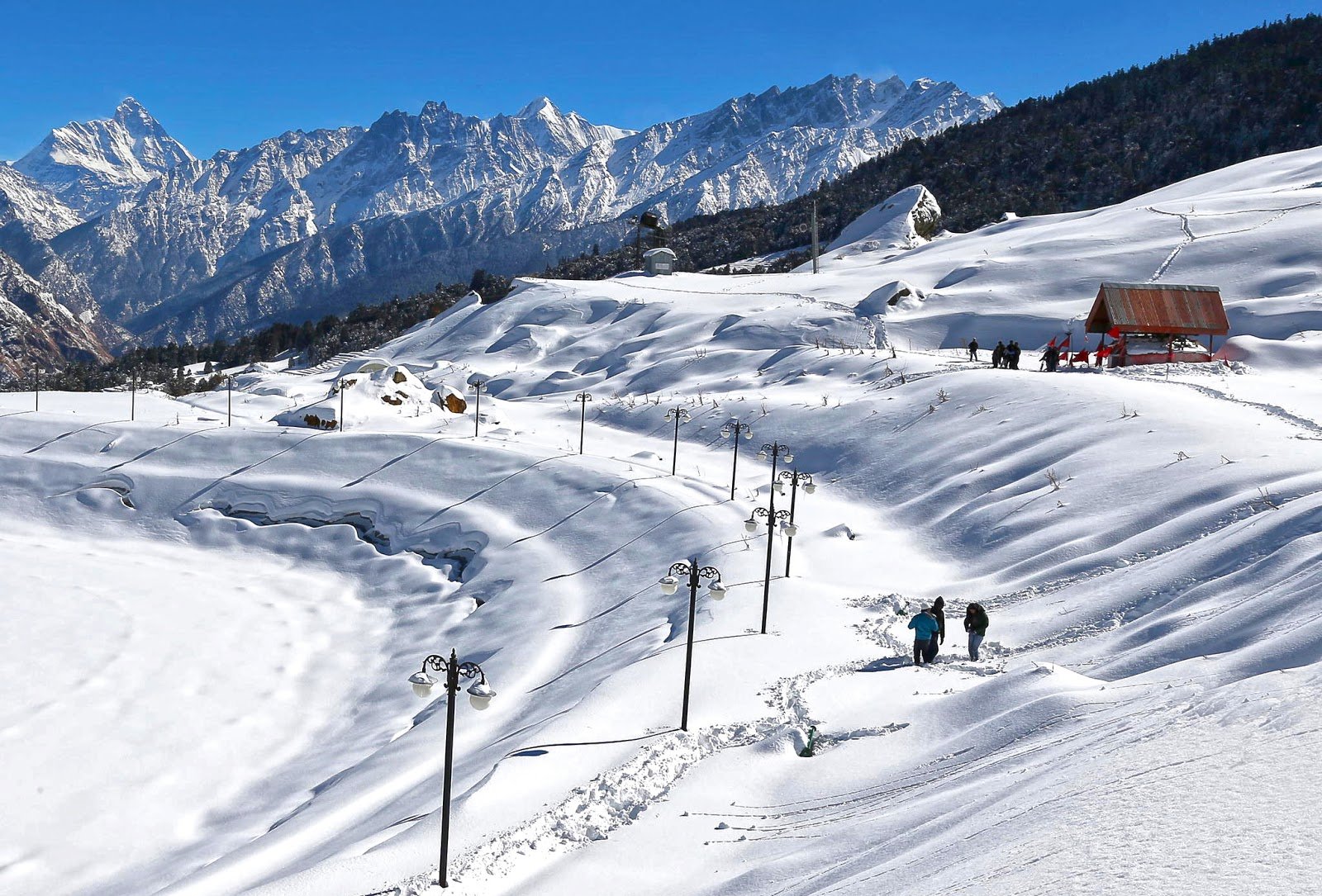
What makes Chamoli truly special is its extraordinary diversity—from the UNESCO World Heritage Site of the Valley of Flowers with its 600+ plant species to the world’s highest Shiva temple at Tungnath, from the ski slopes of Auli to the mysterious Skeleton Lake of Roopkund. The district is also the birthplace of the world-renowned Chipko Movement, a pioneering environmental movement that inspired forest conservation across the globe.
The name “Chamoli” is derived from the Sanskrit word Chandramoli, meaning “One who wears the moon on his head” — a reference to Lord Shiva, who is the presiding deity of this sacred land.
The journey to Chamoli, which begins from the spiritual hubs of Rishikesh or Haridwar, is an accessible yet profoundly rewarding adventure through sacred confluences, ancient temples, and the majestic Himalayan wilderness. It offers a profound sense of peace, spiritual connection, and a deep appreciation for the rich cultural heritage of Uttarakhand.
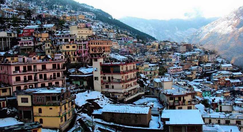
Key Information at a Glance
| Aspect | Details |
|---|---|
| Location | Garhwal Division, Uttarakhand |
| Type | District |
| Established | 24 February 1960 |
| Headquarters | Chamoli Gopeshwar |
| Coordinates | 30°25′N 79°20′E / 30.42°N 79.33°E |
| Area | 8,030 km² (3,100 sq mi) |
| Population (2011) | 391,605 |
| Density | 49/km² |
| Literacy Rate | 82.65% |
| Tehsils | 12 |
| Blocks | 9 |
| Villages | 1,244 |
| Official Language | Hindi |
| Regional Language | Garhwali |
| Nearest Airport | Jolly Grant Airport, Dehradun (~222 km) |
| Nearest Railway Station | Rishikesh (~202 km) |
| Best Time to Visit | March–June & September–October |
| Known For | Badrinath, Valley of Flowers, Auli, Chipko Movement |
History of Chamoli
Ancient Vedic Heritage
Chamoli has a history that dates back to the Vedic period. In ancient times, this region was known as Kedar-khand and was described in the Puranas as the abode of Hindu Gods. It is believed that the Vedas, Puranas, Ramayana, and Mahabharata were scripted in Kedar-khand.
According to the Rigveda (1017–19), after the great inundation (Jalpralya), the Sapt-Rishis (seven sages) saved their lives in the village of Mana, just 4 km from Badrinath. The region’s Garhwali language has many words common with Sanskrit, and the workplaces of Vedic Rishis are prominent pilgrim places in Chamoli.
The Katyuri and Chand Dynasties
The region was ruled by the Katyuri Dynasty from the 3rd century A.D. after the Gupta Dynasty, until the 14th century A.D. when the Chand Dynasty rose to power. The Taleshwar Copper Plate Grant mentions Chamoli District, and one of the copper plates reveals that the ancient city of Brahmapura had one of its administrative centres in Chamoli District.
The Birthplace of the Chipko Movement
Chamoli holds a special place in the history of environmental conservation. The Chipko Movement — a forest conservation movement where villagers, particularly women, hugged trees to protect them from being cut down — was first started in Chamoli in the 1970s. This movement became a global symbol of grassroots environmental activism and inspired similar movements worldwide.
Modern Administrative History
Chamoli was earlier a part of Pauri Garhwal district of the Garhwal Division. On 24 February 1960, the tehsil of Chamoli was upgraded to a new district with its headquarters at Gopeshwar. In October 1997, the district’s boundaries were further reorganised.
Geography of Chamoli
Location and Topography
Chamoli district lies in the Central Himalaya and constitutes a part of the celebrated ‘Kedar Kshetra’. It is the largest district in Uttarakhand by area and is important from a strategic perspective.
| Feature | Details |
|---|---|
| Location | Northeastern part of Uttarakhand, Central Himalaya |
| Coordinates | 30°25′N 79°20′E |
| Area | 8,030 km² |
| Highest Elevation | 7,816 m (Nanda Devi) |
| Lowest Elevation | 800 m |
| Terrain | Lesser and Greater Himalayan ranges |
| Key Rivers | Alaknanda, Pindar, Dhauliganga, Nandakini |
| Borders | Tibet (China) to the north |
Administrative Boundaries
Chamoli district is bounded by:
- North: Tibet (China’s Xizang Autonomous Region)
- East: Pithoragarh and Bageshwar districts
- South: Almora district
- Southwest: Pauri Garhwal district
- West: Rudraprayag district
- Northwest: Uttarkashi district
The Alaknanda River System
The Alaknanda River, one of the two headstreams of the Ganges, flows through Chamoli and is formed by the confluence of the Satopanth and Bhagirath Kharak glaciers above Badrinath. The river passes through the famous Panch Prayag (five confluences), several of which are in Chamoli:
- Vishnuprayag – Alaknanda + Dhauliganga
- Nandprayag – Alaknanda + Nandakini
- Karnaprayag – Alaknanda + Pindar
- Rudraprayag – Alaknanda + Mandakini (partially in Chamoli)
Major Peaks
Chamoli is home to some of the highest and most majestic Himalayan peaks:
| Peak | Elevation |
|---|---|
| Nanda Devi | 7,816 m |
| Kamet | 7,756 m |
| Trishul | 7,120 m |
| Dunagiri | 7,066 m |
| Nanda Ghunti | 6,310 m |
Flora and Fauna
Flora
Chamoli is blessed with extraordinary biodiversity, with a forest cover ranging from 60–80% of the district’s area.
The Valley of Flowers National Park is a UNESCO World Heritage Site and one of the most spectacular floral habitats in the world. Declared a national park in 1982, the valley covers 87.5 km² and is home to more than 600 plant species, including:
- Brahma Kamal (Saussurea obvallata) – Uttarakhand’s state flower
- Aster, Delphinium, Himalayan Blue Poppy
- Ranunculus, Potentilla, Primula, Lilium
- Orchids, Poppies, Marigolds, Daisies, Anemones
- Rare medicinal plants
Forest Types:
- Ringal Forests – Occur above 2,425 m, mixed with high-level oak and coniferous trees
- Alpine Fir Birch Forests – Grow between 2,900 m and 3,500 m
- Tropical Euphorbia Scrub – Found at lower elevations
- Deodar, Pine, Oak, and Spruce forests
Fauna
Chamoli is home to a remarkable variety of Himalayan wildlife, including several endangered species:
Mammals:
- Snow Leopard (endangered)
- Himalayan Black Bear (Asiatic black bear)
- Brown Bear
- Musk Deer
- Bharal (Blue Sheep)
- Red Fox
- Himalayan Tahr
- Serow
- Himalayan Weasel
Birds:
- Himalayan Monal (Uttarakhand’s state bird)
- Golden Eagle
- Bearded Vulture
- Western Tragopan
- Various pheasant species
Protected Areas
| Protected Area | Type | Area |
|---|---|---|
| Valley of Flowers National Park | National Park | 87.5 km² |
| Nanda Devi National Park | National Park | 630 km² |
| Kedarnath Musk Deer Sanctuary | Wildlife Sanctuary | 975 km² |
| Nanda Devi Biosphere Reserve | Biosphere Reserve | UNESCO Site |
Religious Beliefs and Significance
The Land of the Gods
Chamoli is rightly called the “Abode of Gods”. The district is mentioned in the Taleshwar Copper Plate Grant and is deeply revered in Hindu mythology. It is believed that Ved Vyas composed the legendary Mahabharata here, and the land granted creative inspiration to the legendary poet Kalidasa of the Gupta era.
Badrinath Temple
Badrinath, one of the Char Dham pilgrimage sites, is the most famous temple in Chamoli. Dedicated to Lord Vishnu, the temple is believed to have been established by Adi Shankaracharya in the 8th century. The temple is one of the 108 Divya Desams (sacred abodes of Vishnu) and attracts millions of pilgrims annually.
The Panch Kedar Temples
Chamoli is home to two of the five Panch Kedar temples — the five sacred abodes of Lord Shiva:
Rudranath Temple: Located at an altitude of over 3,500 metres, Rudranath holds deep religious importance as the place where the face (mukh) of Lord Shiva is believed to have appeared. According to legend linked to the Mahabharata, the Pandavas searched for Shiva after the Kurukshetra war. The deity, avoiding them, took the form of a bull and disappeared, later reappearing in parts across the region, with his face manifesting at Rudranath. Lord Shiva is worshipped here in his Ekanan form (only his face is revered).
Kalpeshwar Temple: Located in the Urgam Valley at an altitude of 2,134 metres, Kalpeshwar is the only Panch Kedar temple open all year round. It is believed to be the place where Shiva’s hair (jata) appeared.
The Legend of Hanuman and Sanjeevani
The Dronagiri Valley in Chamoli has a fascinating connection to the Ramayana. According to mythology, Lord Hanuman found the Sanjeevani Booti (a mythical medicinal herb) in this valley to revive Laxman during the great war. Interestingly, locals in the Dronagiri valley are said to be angry at Lord Hanuman for taking the Sanjeevani Booti without asking, and blame him for committing theft.
The Nanda Devi Raj Jat Yatra
The Nanda Devi Raj Jat Yatra is a revered once-in-a-12-year Hindu pilgrimage organised in Chamoli. The procession reaches Roopkund, a small pond at an altitude of more than 5,000 metres, surrounded by human skeletons. The bones that litter the shores of Roopkund are believed to be those of one of the ancestors of the royal family that leads the pilgrimage.
Other Significant Temples
| Temple | Deity | Significance |
|---|---|---|
| Gopinath Temple, Gopeshwar | Lord Shiva | Winter seat of Rudranath deity |
| Adi Badri Temples | Lord Vishnu | Group of 16 stone temples |
| Yogadhyanbadri & Vasudevabadri, Pandukeshwar | Lord Vishnu | Ancient temples near Badrinath |
| Kalpeshwar Temple, Urgam | Lord Shiva | Panch Kedar, open all year |
| Rudranath Temple | Lord Shiva | Panch Kedar, face of Shiva |
How to Reach Chamoli
Chamoli is well connected by road and can be easily reached from major cities in Uttarakhand and North India.
By Air
The nearest airport is Jolly Grant Airport in Dehradun, approximately 222 km from Chamoli. Jolly Grant Airport is well connected to Delhi with daily flights. Taxis are available from the airport to Chamoli.
| Route | Distance | Travel Time |
|---|---|---|
| Jolly Grant Airport → Chamoli | ~222 km | 7–8 hours |
By Train
The nearest railway station is Rishikesh, approximately 202 km from Chamoli. Rishikesh is well connected by railway networks with major destinations of India. Trains to Rishikesh are frequent. Taxis and buses are available from Rishikesh to Chamoli.
| Route | Distance | Travel Time |
|---|---|---|
| Rishikesh → Chamoli | ~202 km | 6–7 hours |
By Road
Chamoli is well connected by motorable roads with major destinations in Uttarakhand state. The district is situated on NH-58, making it easily accessible.
| Route | Distance | Travel Time |
|---|---|---|
| Delhi → Chamoli | ~439–459 km | 11–12 hours |
| Dehradun → Chamoli | ~250 km | 8–9 hours |
| Rishikesh → Chamoli | ~202 km | 6–7 hours |
| Haridwar → Chamoli | ~220 km | 7–8 hours |
Bus Services:
- Buses to Rishikesh and Srinagar are available from ISBT Kashmiri Gate, New Delhi
- Buses and taxis to Chamoli are easily available from Rishikesh, Pauri, Uttarkashi, Rudraprayag, Srinagar, and Gopeshwar
Local Transport
Within Chamoli, local transport options include:
- Taxis and shared jeeps for local travel
- Buses connecting major towns and villages
- Walking to explore the scenic beauty and temples
Weather and Best Time to Visit
Climate Overview
Chamoli experiences a subtropical highland climate with distinct seasons, ranging from pleasant summers to severe winters in higher altitudes.
Seasonal Breakdown
| Season | Months | Weather | Suitability |
|---|---|---|---|
| Summer | April–June | Pleasant, 15–30°C | ⭐ Best |
| Monsoon | July–August | Heavy rainfall, landslides, lush greenery | Good for Valley of Flowers |
| Autumn | September–October | Crisp air, clear views | ⭐ Best |
| Winter | November–March | Cold, snowfall in higher areas | Good for Auli skiing |
Best Time to Visit
| Season | Months | Highlights |
|---|---|---|
| Summer | March–June | Pleasant weather, clear views, ideal for trekking and sightseeing |
| Monsoon | July–August | Valley of Flowers in full bloom, lush landscapes |
| Autumn | September–October | Post-monsoon clarity, crisp air, best mountain views |
| Winter | November–March | Snowfall, skiing in Auli, peaceful atmosphere |
Note: The Valley of Flowers opens to the public on June 1 and closes around October 31 for winter. If your purpose is to see the Valley of Flowers, the best time is July–August.
Temperature
| Season | Daytime Temperature | Nighttime Temperature |
|---|---|---|
| Summer (April–June) | 15°C to 30°C | 10°C to 15°C |
| Monsoon (July–August) | 15°C to 20°C | 10°C to 15°C |
| Autumn (Sept–Oct) | 10°C to 25°C | 5°C to 10°C |
| Winter (Nov–March) | 5°C to 15°C | -1°C to 5°C |
Nearby Places
| Destination | Distance | Highlights |
|---|---|---|
| Badrinath | ~90 km from Chamoli | Char Dham temple, Lord Vishnu |
| Valley of Flowers | ~85 km | UNESCO World Heritage Site, 600+ plant species |
| Hemkund Sahib | ~90 km | Sacred Sikh pilgrimage site, high-altitude lake |
| Auli | ~70 km | Skiing capital of India, cable car, meadows |
| Joshimath | ~60 km | Gateway to Badrinath, Shankaracharya Math |
| Gopeshwar | ~15 km | District headquarters, Gopinath Temple |
| Rudranath Temple | ~60 km | Panch Kedar, face of Lord Shiva |
| Kalpeshwar Temple | ~70 km | Panch Kedar, open all year |
| Roopkund | ~100 km | Skeleton Lake, mystery lake |
| Karnaprayag | ~30 km | Confluence of Alaknanda and Pindar |
| Nandprayag | ~25 km | Confluence of Alaknanda and Nandakini |
| Vishnuprayag | ~25 km | Confluence of Alaknanda and Dhauliganga |
| Tungnath | ~80 km | World’s highest Shiva temple |
| Chopta | ~85 km | “Mini Switzerland,” Tungnath base |
| Mana Village | ~95 km | Last village before Badrinath, Vyas Gufa |
| Pandukeshwar | ~85 km | Ancient temples, Tapsthali of King Pandu |
Distance from Major Cities
| City | Distance (Approx.) | Travel Time |
|---|---|---|
| Delhi | 439–459 km | 11–12 hours |
| Dehradun | ~250 km | 8–9 hours |
| Rishikesh | ~202 km | 6–7 hours |
| Haridwar | ~220 km | 7–8 hours |
| Ghaziabad | ~410 km | 10–11 hours |
| Noida | ~450 km | 11–12 hours |
| Gurgaon | ~470 km | 12–13 hours |
| Chandigarh | ~400 km | 10–11 hours |
| Nainital | ~260 km | 8–9 hours |
| Almora | ~200 km | 6–7 hours |
Frequently Asked Questions (FAQs)
General Questions
Q1: What is Chamoli?
A: Chamoli is a district in the Garhwal division of Uttarakhand, known as the “Abode of Gods” for its numerous sacred temples and pilgrimage sites.
Q2: Where is Chamoli located?
A: Chamoli is located in the northeastern part of Uttarakhand, in the Central Himalaya, bounded by Tibet to the north.
Q3: When was Chamoli established as a district?
A: Chamoli was established as a district on 24 February 1960.
Q4: What is the headquarters of Chamoli district?
A: The headquarters of Chamoli district is Chamoli Gopeshwar.
Q5: What is the area of Chamoli district?
A: The total area of Chamoli district is 8,030 km², making it the largest district in Uttarakhand.
Q6: What is the population of Chamoli district?
A: According to the 2011 Census, the population of Chamoli district is 391,605.
Q7: What is the name “Chamoli” derived from?
A: The name “Chamoli” is derived from the Sanskrit word Chandramoli, meaning “One who wears the moon on his head”, denoting Lord Shiva.
Q8: What is Chamoli famous for?
A: Chamoli is famous for Badrinath Temple, Valley of Flowers, Auli ski resort, Panch Kedar temples, and being the birthplace of the Chipko Movement.
Q9: What is the best time to visit Chamoli?
A: The best time is March–June (summer) and September–October (autumn).
Q10: What is the nearest airport to Chamoli?
A: The nearest airport is Jolly Grant Airport in Dehradun, approximately 222 km away.
Q11: What is the nearest railway station to Chamoli?
A: The nearest railway station is Rishikesh, approximately 202 km away.
Q12: How far is Chamoli from Delhi?
A: Chamoli is approximately 439–459 km from Delhi, about an 11–12 hour drive.
Q13: What is the vehicle registration code for Chamoli?
A: The vehicle registration code for Chamoli is UK-11.
Q14: What is the literacy rate of Chamoli?
A: The literacy rate of Chamoli district is 82.65%.
Q15: How many tehsils are in Chamoli district?
A: There are 12 tehsils in Chamoli district.
Q16: What are the major rivers in Chamoli?
A: The major rivers are Alaknanda, Pindar, Dhauliganga, and Nandakini.
Q17: What is the Valley of Flowers?
A: The Valley of Flowers is a UNESCO World Heritage Site in Chamoli, home to more than 600 plant species, including the Brahma Kamal.
Q18: What is Auli famous for?
A: Auli is famous as the skiing capital of India, offering some of the best ski slopes in the country.
Q19: What is the Chipko Movement?
A: The Chipko Movement was a forest conservation movement where villagers hugged trees to protect them from being cut down. It was first started in Chamoli.
Q20: What are the Panch Kedar temples in Chamoli?
A: Rudranath and Kalpeshwar are the two Panch Kedar temples located in Chamoli district.
Q21: What is the significance of Rudranath Temple?
A: Rudranath is where the face (mukh) of Lord Shiva is believed to have appeared. Lord Shiva is worshipped here in his Ekanan form.
Q22: What is the significance of Kalpeshwar Temple?
A: Kalpeshwar is believed to be the place where Shiva’s hair (jata) appeared. It is the only Panch Kedar temple open all year round.
Q23: What wildlife can be found in Chamoli?
A: Chamoli is home to the Snow Leopard, Himalayan Black Bear, Brown Bear, Musk Deer, Bharal (Blue Sheep), Red Fox, Himalayan Tahr, and birds like the Himalayan Monal and Golden Eagle.
Q24: What is the mythological significance of Chamoli?
A: Chamoli is mentioned in ancient scriptures as Kedar-khand, the abode of Hindu Gods. It is believed that Ved Vyas composed the Mahabharata here, and Lord Hanuman found the Sanjeevani Booti in the Dronagiri Valley.
Q25: What is the Nanda Devi Raj Jat Yatra?
A: The Nanda Devi Raj Jat Yatra is a once-in-a-12-year Hindu pilgrimage that passes through Chamoli and reaches Roopkund.
Q26: What is the highest peak in Chamoli?
A: Nanda Devi (7,816 m) is the highest peak in Chamoli and the second-highest in India.
Q27: What is the distance from Rishikesh to Chamoli?
A: The distance from Rishikesh to Chamoli is approximately 202 km.
Q28: What is the distance from Dehradun to Chamoli?
A: The distance from Dehradun to Chamoli is approximately 250 km.
Q29: What is the distance from Haridwar to Chamoli?
A: The distance from Haridwar to Chamoli is approximately 220 km.
Q30: What is the local language of Chamoli?
A: The official language is Hindi, and the regional language is Garhwali.
Essential Tips for Visitors
- Best Time: Plan your visit between March–June or September–October for pleasant weather
- Footwear: Wear comfortable walking shoes as the terrain is hilly and uneven
- Clothing: Carry light woollens even in summer, as evenings can be cool; heavy woollens in winter
- Monsoon Caution: Avoid visiting during July–August due to heavy rainfall and landslides, unless visiting the Valley of Flowers
- Trek Preparation: If planning treks to Rudranath, Roopkund, or Valley of Flowers, ensure good physical fitness and proper gear
- Permits: Obtain necessary forest permits for treks and national park visits
- Local Cuisine: Try local Garhwali dishes like rajma chawal, chainsoo, kachmauli, and mandua roti
- Hydration: Carry water, especially if exploring on foot
- Accommodation: Book in advance during peak pilgrimage seasons (May–June and September–October)
- Respect Local Culture: Chamoli is a sacred land; maintain the sanctity of temples and natural sites
- Leave No Trace: Respect the fragile Himalayan ecosystem
- Inform Family: Let someone know your itinerary, especially if trekking in remote areas
- Altitude Sickness: If visiting high-altitude areas like Badrinath or Rudranath, be aware of symptoms and carry necessary medication
- Weather Updates: Check weather forecasts before travelling, especially during monsoon and winter
Plan Your Chamoli Adventure with Discover Uttarakhand
At Discover Uttarakhand, we’ve been organising unforgettable Himalayan journeys since 1997. As a trusted local operator with deep knowledge of the Garhwal region, we offer:
✅ Customised Chamoli tour packages
✅ Combined itineraries with Badrinath, Valley of Flowers, Auli, and Panch Kedar
✅ Experienced local guides and porters
✅ Comfortable transport with experienced hill drivers
✅ All necessary permits and arrangements
✅ Quality accommodation and nutritious meals
✅ 24/7 customer support throughout your journey
Recommended Chamoli Packages
| Package | Duration | Starting Point | Highlights |
|---|---|---|---|
| Chamoli Darshan | 4 Days / 3 Nights | Rishikesh | Badrinath, Joshimath, Gopeshwar, Auli |
| Valley of Flowers Trek | 6 Days / 5 Nights | Rishikesh | Govindghat, Ghangaria, Valley of Flowers, Hemkund Sahib |
| Panch Kedar Yatra | 10 Days / 9 Nights | Rishikesh | Kedarnath, Tungnath, Rudranath, Madhyamaheshwar, Kalpeshwar |
| Chamoli Complete Expedition | 12 Days / 11 Nights | Dehradun | Badrinath, Valley of Flowers, Auli, Roopkund, Panch Kedar |
📞 Call / WhatsApp: +91-9997187178, 9760222178, 8171977178
📍 Visit Our Office: Himalayan Colony, opposite DSVV, Haripur Kalan, Haridwar, Motichur Range, Uttarakhand 249411
🌐 Website: www.discover-uttarakhand.com
📧 Email:discoveruttarakhand.mail@gmail.com
Plan your journey to Chamoli with proper preparation and respect for this sacred land where mythology comes alive. Experience the divine presence of the Himalayas in one of India’s most spiritually significant and naturally breathtaking destinations.
Discover Uttarakhand – Your Local Partner for Unforgettable Himalayan Journeys Since 1997 🏔️