Overview: The Source of the Bhilangana
Tucked away in the remote reaches of the Garhwal Himalayas, Khatling Glacier is not just a destination; it is a journey into the soul of the mountains. Situated in the Tehri Garhwal district of Uttarakhand, this magnificent glacier serves as the primary source of the Bhilangana River, a key tributary of the Bhagirathi River that ultimately contributes to the Ganges basin.
What makes Khatling Glacier truly special is its raw, untouched beauty and its significance as the largest compound valley glacier in its basin. Located at coordinates approximately 30°50’01.47″N, 78°53’25.79″E, the glacier is surrounded by some of the most magnificent Himalayan peaks, including the Jogin Group (6466 m), Sphetic Pristwar (6905 m), Barte Kauter (6579 m), Kirti Stambh (6902 m), and Meru.
The trek to Khatling Glacier, which begins from the town of Ghuttu, is a challenging yet rewarding adventure through dense forests, scenic villages, and alpine meadows. It is a true test of endurance that rewards trekkers with unparalleled views, a profound sense of accomplishment, and a deep connection with the spiritual heart of the Himalayas.
Key Information at a Glance
History of Khatling Glacier
Scientific Documentation and Glacial Retreat
Khatling Glacier has been the subject of extensive scientific study, making it one of the most well-documented glaciers in the Garhwal Himalayas. Snout position records have been maintained since 1965, providing invaluable data for understanding glacial dynamics and climate change impacts in the region.
The glacier has been experiencing significant retreat due to regional climate warming. Key findings include:
- The glacier retreated 4.34 km between 1965 and 2014 at an average rate of 88 metres per year
- This retreat has resulted in fragmentation into multiple smaller glaciers and a 49% loss in areal extent
- Paleo-glaciological evidence, including lateral and recessional moraines, indicates historical advances extending up to 8.4 km beyond its current position
Mountaineering History
The Jogin Group of Peaks (including Jogin I, II, and III) and other surrounding peaks like Sphetic Pristwar (6905 m) and Kirti Stambh (6902 m) have attracted mountaineers from around the world. The glacier serves as a base for expeditions attempting these formidable peaks.
Geography of Khatling Glacier
Location and Topography
Khatling Glacier is located in the Tehri Garhwal district of Uttarakhand, within the Garhwal Himalayas. It is the largest glacier in the Bhilangna basin.
The Bhilangana River System
Khatling Glacier serves as the primary source of the Bhilangana River, a key tributary of the Bhagirathi River that contributes to the Ganges basin. The glacier’s meltwater supports:
- Local agriculture in the Bhilangana valley
- Biodiversity in the region
- Hydropower generation in the Tehri Reservoir (2400 MW capacity)
High-Altitude Lakes
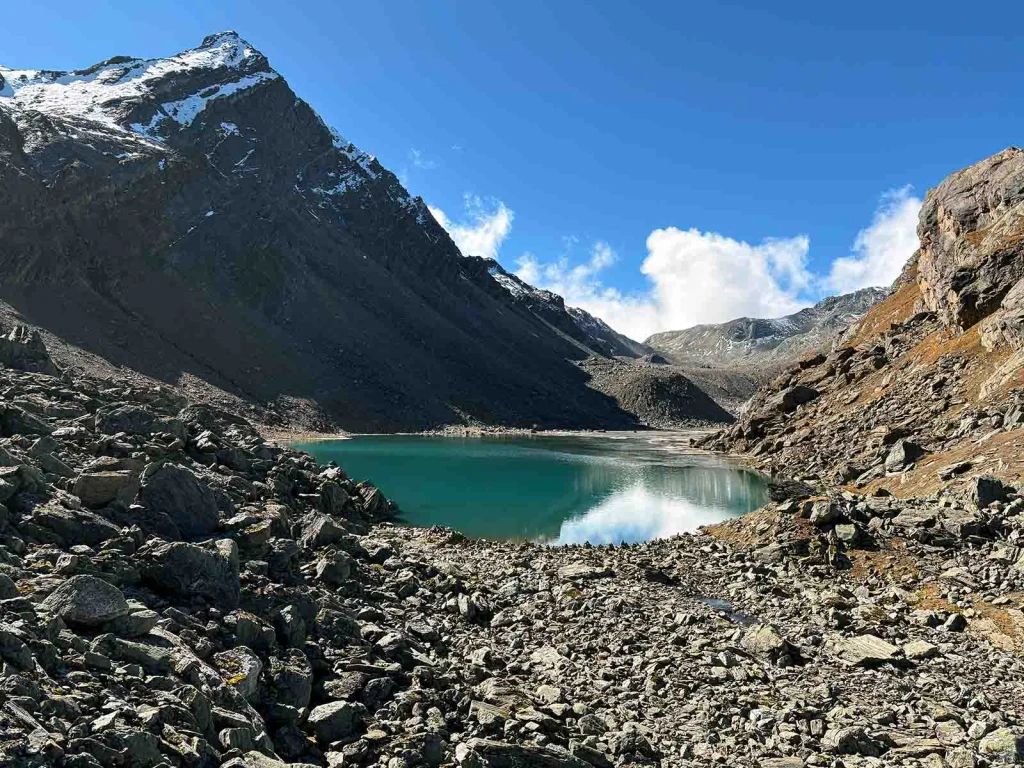
On the west and east of Khatling Glacier, you will find two beautiful high-altitude lakes:
Flora and Fauna
Flora
The region surrounding Khatling Glacier features a great variety of landscapes, climate, and flora, with scores of snowy peaks, many of which exceed 6000 metres in elevation.
Vegetation Zones:
The region is considered a botanically little-known alpine zone, making it of significant interest to botanists and researchers.
Fauna
The area is home to diverse high-altitude Himalayan wildlife:
Mammals:
- Snow Leopard – First spotted near the glacier in 2016 by the Wildlife Institute of India
- Himalayan wildlife including various mountain species
Birds:
- Various bird species
Conservation Status
The region is ecologically sensitive and protected within the Himalayan ecosystem. The Wildlife Institute of India has conducted monitoring of snow leopards and other wildlife above 12,000 feet in the Tehri region. Trekkers are expected to follow Leave No Trace principles and respect the fragile Himalayan ecosystem.
Religious Beliefs and Significance
The Legend of the Bhilangana River
Khatling Glacier holds deep mythological significance as the source of the Bhilangana River.
According to local legend:
A beautiful Bhil maiden (a young woman of the Bhil tribe) attempted to tempt Lord Shiva during his meditation. When she was rejected by the Lord, she dissolved into liquid form out of shame, and her melted form became the Bhilangana River.
This myth is deeply embedded in the local culture, and the river is considered sacred by the communities living in the Bhilangana valley.
Sacred Sites Along the Trek
The trekking route passes through a region rich in temples, shrines, and sacred sites linked to Hindu deities:
- The route offers the option to cover the picturesque Panwali Kantha high-altitude grassland on the return trip
- The trek can culminate at the Trijuginarayan temple – the sacred spot where Lord Shiva and Goddess Parvati tied the knot
- The route also connects to Kedarnath via Vasukital
The Land of the Gods
The Garhwal Himalayas are deeply revered in Hindu mythology and are often referred to as “Devbhoomi” (Land of the Gods). The journey through this region provides a glimpse into the rich cultural heritage of Uttarakhand, fostering a deeper spiritual connection with the majestic Himalayan landscape.
How to Reach Khatling Glacier
The journey to Khatling Glacier requires a combination of road travel and trekking.
By Air
The nearest airport is Jolly Grant Airport in Dehradun, which is well-connected to Delhi and other major cities.
By Train
The nearest railway station is Rishikesh, which is well-connected to Delhi and other major cities.
By Road
| Route | Distance | Travel Time |
|---|---|---|
| Delhi → Rishikesh | ~225 km | 5–6 hours |
| Rishikesh → Tehri | ~100 km | 3–4 hours |
| Tehri → Ghuttu | ~62 km | 6–7 hours |
| Delhi → Ghuttu (Total) | ~400 km | 11–12 hours |
Note: Some sources mention the Delhi to Ghuttu distance as approximately 158 km, but this appears to be an error. The actual distance is closer to 400 km.
Road Options:
- From Rishikesh, the road to Ghuttu passes through Tehri
- From Dehradun, the journey passes through Mussoorie and Tehri
- State-owned and private buses run from Dehradun, Rishikesh, and Tehri to Ghuttu
The Trek Route
The trek to Khatling Glacier starts from Ghuttu, a place about 62 km from Tehri.
Main Trek Route (via Ghuttu):
Alternative Route (via Malla – for longer expedition):
| Segment | Distance | Duration |
|---|---|---|
| Rishikesh → Malla (via Uttarkashi) | Drive | 1 day |
| Malla → Sillachhan | 9 km | 6 hours |
| Sillachhan → Kush Kalyani | 11 km | 6 hours |
| Kush Kalyani → Kyarki Khal | ~8 km | 5-6 hours |
| Kyarki Khal → Partial | ~10 km | 5-6 hours |
| Partial → Sahastral | ~8 km | 4-5 hours |
| Sahastral → Kalyani | ~10 km | 5-6 hours |
| Kalyani → Kharsoli | ~8 km | 4-5 hours |
| Kharsoli → Tambakund | 8 km | 4-5 hours |
| Tambakund → Khatling Glacier | 3 km (round trip) | 4 hours |
⚠️ Important:
- Gangi is the last village beyond which no facilities are available
- Trekkers must arrange tents and other camping essentials well in advance from Rishikesh, Tehri, or Dehradun
- The total trek distance can vary between 45 km and 79 km depending on the route chosen
Permits Required
- A forest entry permit is required for trekking in the region
- Permits can be obtained from the forest department office in Tehri or Ghuttu
- Trekkers must register with local authorities before embarking on the trek
Weather and Best Time to Visit
Climate Overview
Khatling Glacier experiences a high-altitude alpine climate. Days are cool and pleasant, but nights can drop well below freezing, even during the open season. Sudden weather changes are common.
Seasonal Breakdown
| Season | Months | Weather | Trekking Suitability |
|---|---|---|---|
| Summer (Peak) | May–June | Pleasant (15- 25 °C during the day), clear skies, snow melting | ⭐ Best |
| Monsoon | July–August | Heavy rainfall, landslides, trails slippery | ❌ Not Recommended |
| Autumn | September–October | Crisp air, clear views, mild temperatures | ⭐ Best |
| Winter | November–April | Heavy snowfall, extreme cold, routes closed | ❌ Closed |
Best Time to Visit
| Season | Months | Highlights |
|---|---|---|
| Summer | May–June | Pleasant weather, clear views, accessible trails, wildflowers |
| Autumn | September–October | Post-monsoon clarity, crisp air, golden landscapes, clear mountain views |
Note: The trek to Khatling Glacier is generally open from May to October. The monsoon months of July and August should be avoided due to heavy rains and landslides.
Temperature
| Season | Daytime Temperature | Nighttime Temperature |
|---|---|---|
| Summer (May–June) | 15°C to 25°C | 5°C to 10°C |
| Autumn (Sept–Oct) | 10°C to 20°C | 0°C to 5°C |
| At Glacier | Near freezing or below | Well below freezing |
Snowfall
- Winter (November to April): Heavy snowfall, route completely closed
- Early Summer (May): Snow begins to melt, trails become accessible
- Late Autumn (October): First snowfalls begin, trekking becomes challenging
Nearby Places
Distance from Major Cities
| City | Distance (Approx.) | Travel Time |
|---|---|---|
| Delhi | 400–425 km | 11–12 hours |
| Dehradun | ~150 km | 5–6 hours |
| Rishikesh | ~180 km | 6–7 hours |
| Haridwar | ~200 km | 6–7 hours |
| Tehri | ~62 km | 2–3 hours |
| Mussoorie | ~150 km | 5–6 hours |
| Uttarkashi | ~190 km | 6–7 hours |
Frequently Asked Questions (FAQs)
General Questions
Q1: Where is Khatling Glacier located?
A: Khatling Glacier is located in the Tehri Garhwal district of Uttarakhand, in the Garhwal Himalayas.
Q2: What is the altitude of Khatling Glacier?
A: The glacier’s snout is at approximately 3,905 metres (12,800 feet). The trek reaches a maximum altitude of approximately 4,970 metres (16,300 feet).
Q3: What is the length of Khatling Glacier?
A: As of 2014, the glacier measured 10.9 km in length and covered 29.5 km² in area.
Q4: What river originates from Khatling Glacier?
A: Khatling Glacier is the primary source of the Bhilangana River.
Q5: What is the best time to visit Khatling Glacier?
A: The best time is May to June (summer) and September to October (autumn).
Q6: How long is the trek to Khatling Glacier?
A: The trek is approximately 45 km from Ghuttu, taking 9 to 15 days round trip depending on the route.
Q7: Is the Khatling Glacier trek difficult?
A: The trek is considered moderate to difficult/strenuous and is recommended for trekkers with good physical fitness.
Q8: Do I need a permit to visit Khatling Glacier?
A: Yes, a forest entry permit is required. Trekkers must register with the local forest department.
Q9: What peaks can I see from Khatling Glacier?
A: From Khatling Glacier, you can see the Jogin Group (I, II, III), Sphetic Pristwar (6905 m), Barte Kauter (6579 m), Kirti Stambh (6902 m), and Meru.
Q10: What wildlife can be found in the area?
A: The region is home to the snow leopard (first spotted in 2016), various Himalayan wildlife, and bird species.
Q11: What is the nearest town to Khatling Glacier?
A: Ghuttu is the nearest town and serves as the starting point for the trek.
Q12: Is mobile connectivity available at Khatling Glacier?
A: Mobile connectivity is limited or non-existent in this remote region. It is advisable to inform your family of your itinerary before starting the trek.
Q13: What is the distance from Delhi to Ghuttu?
A: The distance is approximately 400 km by road, taking about 11–12 hours.
Q14: What should I pack for the Khatling Glacier trek?
A: Pack thermal wear, fleece, a down jacket, waterproof trekking shoes, warm socks, gloves, a woollen cap, sunscreen, sunglasses, a headlamp, and a sleeping bag (-10°C rating).
Q15: How many days are required for the Khatling Glacier trek?
A: The trek typically takes 9 to 15 days to complete, depending on the route.
Q16: What is the mythological significance of the Bhilangana River?
A: According to legend, a Bhil maiden tried to tempt Lord Shiva and, upon rejection, dissolved into liquid to become the Bhilangana River.
Q17: Are there high-altitude lakes near Khatling Glacier?
A: Yes, Sahasratal (west) and Masartal (east) are two beautiful high-altitude lakes near the glacier.
Q18: Can I camp at Khatling Glacier?
A: Yes, camping is permitted in designated areas. Trekkers must arrange tents and camping essentials from Rishikesh, Tehri, or Dehradun.
Q19: Is the trek suitable for beginners?
A: This trek is recommended for experienced trekkers with good physical fitness and prior high-altitude trekking experience.
Q20: What is the retreat rate of Khatling Glacier?
A: The glacier retreated 4.34 km between 1965 and 2014 at an average rate of 88 metres per year.
Essential Tips for Trekkers
- Acclimatisation: Spend at least 1–2 days in Ghuttu or Tehri to acclimatise to the altitude
- Physical Fitness: The trek requires good physical fitness; train by walking, jogging, swimming, and biking
- Permits: Obtain all necessary permits from the forest department well in advance
- Guide: Hire an experienced local guide familiar with the terrain
- Gear: Carry proper high-altitude trekking gear including warm clothing, sturdy boots, and camping equipment
- Weather: Check weather forecasts before starting the trek
- Hydration: Stay well-hydrated; carry water purification tablets
- AMS Medication: Carry AMS medication and portable oxygen cylinders to ensure a safe trip
- Leave No Trace: Respect the fragile Himalayan ecosystem
- Insurance: Consider travel insurance covering high-altitude trekking
- Inform Family: Let someone know your trek itinerary as there is no mobile signal on the trail
- Arrangements: Arrange tents and other camping essentials well in advance from Rishikesh, Tehri, or Dehradun
Plan Your Khatling Glacier Adventure with Discover Uttarakhand
At Discover Uttarakhand, we’ve been organising unforgettable Himalayan journeys since 1997. As a trusted local operator with deep knowledge of the Garhwal region, we offer:
✅ Customised Khatling Glacier trek packages (9 to 15 days)
✅ Combined itineraries with Sahasratal, Masartal, and Kedarnath
✅ Experienced local guides and porters
✅ Comfortable transport with experienced hill drivers
✅ All necessary permits and arrangements
✅ Quality camping equipment and nutritious meals
✅ 24/7 customer support throughout your journey
Recommended Khatling Glacier Packages
| Package | Duration | Starting Point | Highlights |
|---|---|---|---|
| Khatling Glacier Trek | 9 Days / 8 Nights | Rishikesh | Ghuttu, Gangi, Kalyani, Khatling Glacier |
| Khatling & Sahasratal Trek | 12 Days / 11 Nights | Rishikesh | Khatling Glacier, Sahasratal Lake, alpine meadows |
| Complete Khatling Expedition | 15 Days / 14 Nights | Dehradun | Khatling Glacier, Sahasratal, Masartal, Panwali Kantha |
📞 Call / WhatsApp: +91-9997187178, 9760222178, 8171977178
📍 Visit Our Office: Himalayan Colony, opposite DSVV, Haripur Kalan, Haridwar, Motichur Range, Uttarakhand 249411
🌐 Website: www.discover-uttarakhand.com
📧 Email: discoveruttarakhand.mail@gmail.com
Plan your expedition to Khatling Glacier with proper preparation, permits, and respect for the magnificent Himalayan wilderness. This pristine glacier offers an unforgettable journey into one of India’s most remote and breathtaking landscapes.
Discover Uttarakhand – Your Local Partner for Unforgettable Himalayan Journeys Since 1997 🏔️