Overview: The Hidden Gem of the Bhilangna Valley
Tucked away in the remote Bhilangna Valley of the Tehri Garhwal district, Masar Tal is not just a destination; it is a journey into the soul of the Garhwal Himalayas and a pilgrimage to one of its most pristine and isolated glacial lakes.
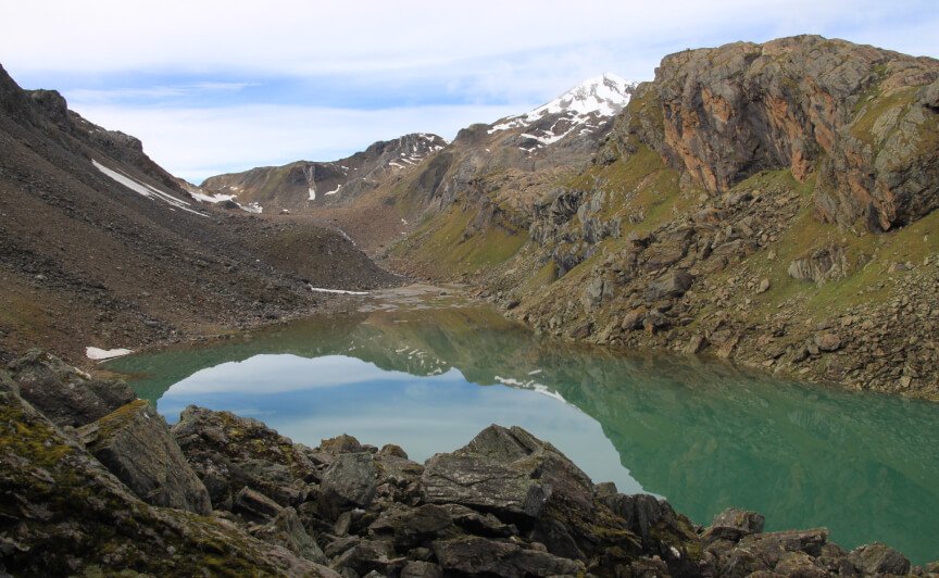
Often referred to as a “Hidden Gem of Uttarakhand”, this magnificent high-altitude lake is a land of unparalleled natural beauty and profound spiritual significance. Located in the Tehri Garhwal district of Uttarakhand, Masar Tal is situated below the Masar Top on the left flank of the Doodhganga Bamak (West), en route to the challenging Mayali Pass.
What makes Masar Tal truly special is its extraordinary diversity—from the rippling Bhilangna River that serves as its vital source to the sprawling alpine green meadows locally known as ‘Bugyal’, from the dense woodlands and meandering meadows to the snowy Himalayan peaks that surround it. The lake is a living repository of Himalayan folklore, with legends that connect it to Lord Shiva and Goddess Parvati, and stories from the Mahabharata.
The name “Masar Tal” is also written as Masartal, Mahsartal Lake, and Mahsar Tal, and it is famous for its trekking route and religious importance among the locals. The journey to Masar Tal, which begins from the spiritual hubs of Rishikesh or Dehradun, is an accessible yet profoundly rewarding adventure through sacred confluences, ancient temples, and the majestic Himalayan wilderness. It offers a profound sense of peace, spiritual connection, and a deep appreciation for the rich cultural heritage of Uttarakhand.
Key Information at a Glance
History of Masar Tal
Ancient Roots in the Khatling Glacier
Masar Tal has a history that is deeply intertwined with the ancient Khatling Glacier, the source of the Bhilangana River and one of the largest and most remote glaciers in the Gangotri group. The lake is situated en-route to Sahastra Tal in the Balganga Valley, which is made up of two bowl-shaped lakes.
The Mythological Connection
Masar Tal is steeped in mythological significance. The area has mythical stories, with myths related to Lord Shiva and Goddess Parvati, and stories from the Mahabharata also associated with this region. The lake is also famous for its religious importance among the locals, adding to its spiritual significance.
The Expansion of the Lake
A change analysis of the lake water spread area carried out using Hexagon KH-9 of 1980 and Sentinel-2 of 2023 multi-temporal optical imagery revealed a 1,319% increase in size from 2.48 ha to 35.19 ha. This alarming rate of lake expansion has necessitated a detailed GLOF (Glacial Lake Outburst Flood) risk assessment, as the lake now holds approximately 7.82 MCM of water.
The Trekking Legacy
Masar Tal has been a part of the legendary Khatling Glacier Trek and the Mayali Pass Trek for decades. The trek passes through the stunning Masar Tal lake and dense rhododendron forest before reaching the vast expanse of ice beneath towering peaks, including Jogin and Sphetic Pristwar. The lake is one of the most isolated lakes of the Garhwal region, and its eye-captivating scenery makes it a popular trek.
Geography of Masar Tal
Location and Topography
Masar Tal is situated at an elevation of 4,139 metres (13,579 feet) above sea level in the Tehri Garhwal district of Uttarakhand. It is just below Masar Top on the Doodhganga’s left bank. The lake is located in the Bhilangna Valley, which offers panoramic views of hanging glaciers and snow-covered peaks.
The Bhilangna River System
The Bhilangna River is the vital source of Masar Tal. The river originates from the Khatling Glacier and traverses about 9.7 km, where the Masar Tal glacial lake stream joins from the left side. The Bhilangna River is the principal tributary of the Bhagirathi River, which is the source stream of the Gangotri group of glaciers. The stream emerging from Masar Tal flows for about 6 km and joins the Bhilangna River on the left side.
The Himalayan Panorama
The area around Masar Tal offers breathtaking views of the Jogin group of peaks at 6,466 metres, Barte Kauter, and other snow-capped Himalayan summits. The Khatling Glacier lies between Masar Tal and Sahastra Tal, with Masar Tal to the east and Sahastra Tal to the west of the glacier.
Major Landmarks
- Masar Top – The peak just above Masar Tal
- Khatling Glacier – The source of the Bhilangna River
- Sahastra Tal – The lake on the western side of Khatling Glacier
- Mayali Pass – A high-altitude pass on the trek route
- Vasuki Tal – Another high-altitude lake on the route to Kedarnath
Flora and Fauna
Flora
Masar Tal is blessed with extraordinary biodiversity, with the lake surrounded by dense woodlands, meandering meadows, and sprawling alpine green meadows known as ‘Bugyal’ in the local language.
Vegetation:
- Alpine Meadows (Bugyal) – Sprawling green meadows covered with varied wildflowers
- Rhododendron Forests – Dense rhododendron forests on the approach to the lake
- Dense Woodlands – Surrounding the lake
- Wildflowers – The meadows are covered with varied wildflowers, making walking barefoot feel like drifting on clouds
The area is highly biodiverse with many different species of plants. The alpine meadows around the lake are a sight to behold, especially during the blooming season.
Fauna
Masar Tal is one of the hidden gems of Uttarakhand, nestled amidst the Himalayan ranges of the Garhwal region, and the location is highly biodiverse with many different species of animals, birds, and plants.
Mammals:
- Himalayan Black Bear
- Leopard
- Musk Deer
- Barking Deer (Kakar)
- Red Fox
- Himalayan Tahr
- Serow
Birds:
- Himalayan Monal – Uttarakhand’s state bird
- Golden Eagle
- Bearded Vulture
- Western Tragopan
- Various pheasant species
Protected Areas
Religious Beliefs and Significance
The Land of Shiva and Parvati
Masar Tal is deeply connected to Hindu mythology. The area has mythical stories, with myths related to Lord Shiva and Goddess Parvati, and stories from the Mahabharata also associated with this region. The lake is famous for its religious importance among the locals, adding to its spiritual significance.
The Bhai-Bahen Tal
According to local legend, Masar Tal is also known as “Bhai-Bahen Tal” (Brother-Sister Lake) because a mythological story is associated with this place. This sacred connection adds a layer of spiritual significance to the lake, making it a place of reverence for the local communities.
The Sacred Waters
The pristine lake of Masar Tal is surrounded by dense forests and is situated amongst meandering meadows. The waters of the lake are considered sacred by the local communities, and the lake holds deep spiritual significance for those who undertake the arduous trek to reach it.
The Khatling Glacier Connection
The Khatling Glacier is the source of the Bhilangna River, and the area around it is considered highly sacred. The trek to Masar Tal passes through the Kedarnath National Park, adding to the spiritual significance of the journey. The region is dotted with several other beautiful spots like Masar Tal and Tevra Tal, which are twin lakes found along the Mayali Pass trail.
Local Festivals and Celebrations
- Local Fairs – Traditional fairs that showcase the vibrant culture of the Garhwal region
- Harela – A festival celebrating the sowing of seeds and the arrival of spring
- Diwali – The festival of lights
How to Reach Masar Tal
Masar Tal is well connected by road and can be easily reached from major cities in Uttarakhand and North India.
By Air
The nearest airport is Jolly Grant Airport in Dehradun, approximately 192 km from the trek base at Ghuttu. Jolly Grant Airport is well connected to Delhi with daily flights. Taxis are available from the airport to Rishikesh or Dehradun, from where the journey continues by road.
| Route | Distance | Travel Time |
|---|---|---|
| Jolly Grant Airport → Ghuttu | ~192 km | 7–8 hours |
By Train
The nearest railway station is Rishikesh, approximately 180 km from the trek base. Rishikesh is well connected by railway networks with major destinations in India. Taxis and buses are available from Rishikesh to Ghuttu.
| Route | Distance | Travel Time |
|---|---|---|
| Rishikesh → Ghuttu | ~180 km | 7–8 hours |
By Road
Masar Tal is accessible via a trek from Ghuttu village in the Tehri Garhwal district. A long drive of roughly 10–11 hours covers the distance from Delhi to Ghuttu via Rishikesh and Tehri.
| Route | Distance | Travel Time |
|---|---|---|
| Delhi → Ghuttu | ~414 km | 10–11 hours |
| Rishikesh → Ghuttu | ~180 km | 7–8 hours |
| Dehradun → Ghuttu | ~178 km | 6–7 hours |
| Uttarkashi → Ghuttu | ~25 km | 1 hour |
The Trek Route:
The trek starts from Ghuttu village and proceeds through the following stages:
- Day 1: Delhi to Ghuttu (drive)
- Day 2: Ghuttu to Reeh (trek through dense forest along the Bhilangana River)
- Day 3: Reeh to Gangi/Kalyani Camp (through forest and open terrain)
- Day 4: Kalyani Camp to Masar Tal (climb through alpine meadow)
- Day 5: Masar Tal to Khatling Glacier and back
- Day 6-8: Descent to Ghuttu
Alternative Route:
The Masar Tal trek can also be approached via the Khatling Glacier Trek or the Mayali Pass Trek. The full Masar Tal Trek is a 15-day expedition starting from Dehradun and ending at Dehradun.
Local Transport
Within the region, local transport options include:
- Taxis and shared jeeps for local travel
- Walking – The only way to reach Masar Tal is by trekking
- Local guides – Highly recommended for the remote and challenging terrain
Weather and Best Time to Visit
Climate Overview
Masar Tal experiences a Himalayan climate with distinct seasons, ranging from pleasant summers to extremely cold winters. The lake’s elevation of 4,139 metres ensures cold temperatures for most of the year.
Seasonal Breakdown
Best Time to Visit
| Season | Months | Highlights |
|---|---|---|
| Summer | May–June | Pleasant weather, clear views, ideal for trekking |
| Autumn | September–October | Post-monsoon clarity, crisp air, best mountain views |
Note: The best time to visit Masar Tal is from May to June and September to October. The route is closed during the winter months due to heavy snowfall, and the monsoon season (July–August) poses landslide risks on the long forest approach.
Temperature
| Season | Daytime Temperature | Nighttime Temperature |
|---|---|---|
| Summer (May–June) | 8°C to 15°C | 0°C to 5°C |
| Monsoon (July–August) | 5°C to 10°C | 0°C to 5°C |
| Autumn (Sept–Oct) | 5°C to 12°C | -2°C to 5°C |
| Winter (Nov–April) | Below freezing | Below -10°C |
The campsite at Masar Tal gets very cold, so trekkers need to be well prepared with proper gear.
Nearby Places
Distance from Major Cities
| City | Distance (Approx.) | Travel Time |
|---|---|---|
| Delhi | ~414 km (to Ghuttu) | 10–11 hours |
| Dehradun | ~178 km | 6–7 hours |
| Rishikesh | ~180 km | 7–8 hours |
| Haridwar | ~200 km | 7–8 hours |
Frequently Asked Questions (FAQs)
General Questions
Q1: What is Masar Tal?
A: Masar Tal is a high-altitude glacial lake in the Tehri Garhwal district of Uttarakhand, known for its pristine beauty, trekking routes, and religious significance.
Q2: Where is Masar Tal located?
A: Masar Tal is located in the Tehri Garhwal district of Uttarakhand, in the Bhilangna Valley, below the Masar Top on the left flank of the Doodhganga Bamak (West).
Q3: What is the elevation of Masar Tal?
A: Masar Tal is situated at an elevation of 4,139 metres (13,579 feet) above sea level.
Q4: What is Masar Tal famous for?
A: Masar Tal is famous for its glacial lake, trekking routes, alpine meadows, and religious importance among the locals.
Q5: What is the best time to visit Masar Tal?
A: The best time is May–June and September–October.
Q6: What is the nearest airport to Masar Tal?
A: The nearest airport is Jolly Grant Airport in Dehradun, approximately 192 km away.
Q7: What is the nearest railway station to Masar Tal?
A: The nearest railway station is Rishikesh, approximately 180 km away.
Q8: How far is Masar Tal from Delhi?
A: Masar Tal is approximately 414 km from Delhi (to the trek base at Ghuttu), about a 10–11 hour drive.
Q9: What is the vehicle registration code for the region?
A: The vehicle registration code is UK-09 (Tehri Garhwal district).
Q10: What is the lake area of Masar Tal?
A: The lake area is 35.19 hectares as of 2023.
Q11: What are the major rivers near Masar Tal?
A: The major river is the Bhilangna River, which originates from the Khatling Glacier.
Q12: What is the mythological significance of Masar Tal?
A: The area has mythical stories related to Lord Shiva and Goddess Parvati, and stories from the Mahabharata.
Q13: What is the Bhai-Bahen Tal legend?
A: Masar Tal is also known as “Bhai-Bahen Tal” (Brother-Sister Lake) because of a mythological story associated with this place.
Q14: What wildlife can be found near Masar Tal?
A: The region is home to Himalayan black bear, leopard, musk deer, barking deer, red fox, Himalayan tahr, and various bird species, including the Himalayan Monal.
Q15: How do I reach Masar Tal from Ghuttu?
A: The trek from Ghuttu to Masar Tal takes approximately 3–4 days, passing through Reeh, Gangi/Kalyani Camp, and then to Masar Tal.
Q16: What is the trek difficulty level of Masar Tal?
A: The Masar Tal trek is rated difficult due to its length (8+ days of continuous trekking), high altitude, and remote terrain.
Q17: What is the trek duration for Masar Tal?
A: The full Masar Tal Trek is 15 days / 14 nights from Dehradun to Dehradun.
Q18: What is the local language of the region?
A: The official language is Hindi, and the regional language is Garhwali.
Q19: Is Masar Tal a good destination for offbeat travellers?
A: Yes, Masar Tal is an offbeat destination perfect for those seeking remote trekking, glacial lakes, and Himalayan scenery away from crowded tourist spots.
Q20: What are the nearby places to visit from Masar Tal?
A: Nearby places include Khatling Glacier (6 km), Sahastra Tal (12 km), Vasuki Tal (15 km), Ghuttu Village (30 km), and Kedarnath (50 km) .
Q21: What is the Khatling Glacier?
A: The Khatling Glacier is the source of the Bhilangna River and one of the largest and most remote glaciers in the Gangotri group.
Q22: What food is available at Masar Tal?
A: There are no shops or eateries at Masar Tal. Trekkers must carry all food and supplies. The trek operator typically provides meals during the trek.
Q23: Is photography allowed at Masar Tal?
A: Yes, photography is allowed and is one of the main activities. The sunrise and sunset views are particularly spectacular.
Q24: Can I camp at Masar Tal?
A: Yes, camping is allowed at Masar Tal. The campsite is set at a location from which you can enjoy the surroundings heartily.
Q25: What is the distance from Rishikesh to Masar Tal?
A: The distance from Rishikesh to the trek base at Ghuttu is approximately 180 km.
Q26: What is the distance from Dehradun to Masar Tal?
A: The distance from Dehradun to the trek base at Ghuttu is approximately 178 km.
Q27: What is the significance of the Khatling Glacier?
A: The Khatling Glacier is the source of the Bhilangna River and is surrounded by towering peaks, including Jogin and Sphetic Pristwar.
Q28: What is the Mayali Pass?
A: The Mayali Pass is a high-altitude pass on the trek route that connects the Bhilangna Valley to Kedarnath.
Q29: What is the best way to explore Masar Tal?
A: The best way is by trekking — the lake is only accessible on foot, and the journey is as rewarding as the destination.
Q30: What should I carry for a trek to Masar Tal?
A: Carry warm clothing, trekking gear, camping equipment, food, water, and a first-aid kit. The area is remote, with no shops or medical facilities.
Essential Tips for Visitors
- Best Time: Plan your trek between May–June or September–October for the best weather conditions
- Footwear: Wear sturdy trekking shoes with good grip for the rocky and uneven terrain
- Clothing: Carry heavy woollens, thermals, and waterproof layers — the campsite at Masar Tal gets very cold
- Monsoon Caution: Avoid trekking during July–August due to heavy rainfall and landslide risk
- Trek Preparation: Ensure good physical fitness and proper acclimatisation for the high altitude
- Permits: Obtain necessary forest permits for the trek and national park visits
- Local Cuisine: Carry your own food and supplies as there are no shops at Masar Tal
- Hydration: Carry water purification tablets or a filter, as natural water sources may not be safe
- Accommodation: Camping is the only option at Masar Tal; carry your own tent and sleeping bag
- Respect Local Culture: Masar Tal is a sacred site; maintain the sanctity of the lake and natural surroundings
- Leave No Trace: Respect the fragile Himalayan ecosystem — carry back all waste
- Inform Family: Let someone know your itinerary before trekking, as there is no mobile connectivity in the remote areas
- Altitude Sickness: Be aware of symptoms and carry necessary medication
- Weather Updates: Check weather forecasts before travelling, especially during monsoon and winter
- Experienced Operator: Due to the remote and challenging nature of the trek, it is highly recommended to trek with an experienced operator
- GLOF Awareness: The lake has expanded significantly in recent decades; be aware of the GLOF risk assessment for the region
Plan Your Masar Tal Adventure with Discover Uttarakhand
At Discover Uttarakhand, we’ve been organising unforgettable Himalayan journeys since 1997. As a trusted local operator with deep knowledge of the Garhwal region, we offer:
✅ Customised Masar Tal trek packages
✅ Combined itineraries with Khatling Glacier, Sahastra Tal, and Kedarnath
✅ Experienced local guides and high-altitude trek leaders
✅ Comfortable transport with experienced hill drivers
✅ All necessary permits and arrangements
✅ Quality camping equipment and nutritious meals
✅ 24/7 customer support throughout your journey
Recommended Masar Tal Packages
📞 Call / WhatsApp: +91-9997187178, 9760222178, 8171977178
📍 Visit Our Office: Himalayan Colony, opposite DSVV, Haripur Kalan, Haridwar, Motichur Range, Uttarakhand 249411
🌐 Website: www.discover-uttarakhand.com
📧 Email: discoveruttarakhand.mail@gmail.com
Plan your journey to Masar Tal with proper preparation and respect for this sacred land where mythology comes alive. Experience the divine presence of the Himalayas in one of India’s most remote and naturally breathtaking destinations.
Discover Uttarakhand – Your Local Partner for Unforgettable Himalayan Journeys Since 1997 🏔️