Introduction: The Ghost Village Frozen in Time
Hidden deep in the Kumaon Himalayas of Uttarakhand’s Pithoragarh district, Milam Valley—also known as the Johar Valley or Gori Ganga Valley—is one of the most hauntingly beautiful destinations in the Indian Himalayas. At an altitude of approximately 3,500 meters (11,500 feet), this remote valley stretches from the mountain town of Munsiyari towards the high peaks of the Himalayas, following the course of the Gori Ganga River to its source at the Milam Glacier.
Milam is not just a destination—it is a story frozen in time. Once a bustling trade hub on the ancient Silk Route to Tibet, this village was home to over 400 families who thrived on trans-Himalayan trade. Tibetan merchants would arrive with their yaks, carrying wool, salt, borax, and precious stones to trade for rice, cotton clothes, jaggery, and sugar from India. The village was so large that legend has it that newlywed brides would often lose their way in the maze-like alleys and end up in the wrong house.
Today, Milam stands as a ghost village. The 1962 Sino-Indian War sealed the borders, and the ancient trade routes fell silent. The once-prosperous Shauka (Bhotiya) community was evacuated to lower areas, leaving behind their stone houses with slate roofs and intricately carved doorframes. In the summer months, a handful of descendants return to cultivate medicinal plants, high-altitude buckwheat, and Jambhu, while the rest of the year, the village lies empty under a blanket of snow.
Whether you are a trekker seeking one of the most rewarding glacier treks in Uttarakhand, a history enthusiast walking in the footsteps of legendary explorer Nain Singh Rawat, a birdwatcher hoping to spot the Himalayan Monal, or a traveller drawn to the romance of abandoned villages, Milam Valley promises an unforgettable Himalayan journey.
Key Information at a Glance:
| Aspect | Details |
|---|---|
| Location | Johar Valley, Pithoragarh district, Uttarakhand |
| Altitude | 3,434–3,500 meters (11,266–11,483 ft) |
| River | Gori Ganga River (originates from Milam Glacier) |
| Status | Mostly abandoned (ghost village), summer habitation only |
| Famous For | Ancient Tibet trade route, Milam Glacier, Shauka culture, Nain Singh Rawat |
| Nearest Town | Munsiyari (~60 km trekking distance) |
| Nearest Airport | Pantnagar (~435 km) |
| Nearest Railway Station | Tanakpur (~331 km) / Kathgodam |
| Trekking Season | May–October (monsoon months to be avoided) |
History: The Ancient Silk Route of the Himalayas
The Indo-Tibetan Trade Corridor
Milam Valley’s history is inseparable from the ancient trans-Himalayan trade routes that connected India with Tibet. Before the 1962 Sino-Indian War, the valley was a vital corridor for merchants carrying goods across high mountain passes like Unta Dhura, Jandi Dhura, and Kingribingri Dhura to Gyanima Mandi in Tibet.
At its peak in the early 1900s, Milam was a thriving trade centre where Shauka tribesmen (also known as Bhotiyas or Joharis), traditionally farmers and shepherds, became successful and prosperous merchants. They travelled over 1,500 km east to Kolkata to procure silk, spices, and other goods to trade with Tibet.
Tibetan merchants would make the reverse journey with their yaks and other livestock to reach Milam, the first village on the Indian side of the border, where they traded wool, salt, borax, pashmina, and precious stones for rice, cotton clothes, jaggery, and sugar.
A Village of Legends
Milam was so large and prosperous that local legends claim that newlywed brides, after fetching water from nearby springs, would often lose their way in the maze-like alleys and end up in the wrong house. There’s even a spot on the cliff above the village, still marked by a flag, from where people would loudly call the lost women and give them directions.
Stones engraved with Tibetan text are still commonly found in the abandoned villages, a testament to this thriving trade route.
The Famous Pundit-Explorers of Milam
Milam holds a distinguished place in the history of Himalayan exploration. The village is the birthplace of two legendary Indian explorers:
These “pundit-explorers” were trained by the British to survey the forbidden lands of Tibet disguised as pilgrims, and their contributions to the mapping of Central Asia remain unparalleled.
The 1962 Closure and Abandonment
The Sino-Indian War of 1962 changed everything. After a series of failed dialogues between the two countries, the borders were sealed, and platoons of Indian soldiers were deployed in the Johar Valley. The villages were evacuated, and the Shaukas moved to lower areas—primarily Munsiyari—where they were offered land and jobs in the government. The trade with Tibet came to an abrupt end.
Milam, once home to 400 families, became a ghost village.
The Slow Return
The valley finally reopened in 1994, but with strict rules. Even today, all visitors are carefully monitored, with bags searched and cameras checked. A permit is required, along with approval from the ITBP and clearance from the forest department.
In summer months, very few people—mostly descendants of the original inhabitants—return to Milam to cultivate medicinal plants, high-altitude buckwheat, and Jambhu. Stones engraved with Tibetan text are still commonly found in the abandoned villages, a testament to this thriving trade route.
The New Road
The Munsiari-Bugdiar-Milam Road (MBMR) is being constructed by the Border Roads Organisation (BRO) as part of the India–China Border Roads (ICBRs), with an expected completion date of March 2026. This paved motorable road will eventually connect Milam village with the district sub-division headquarters Munsiyari, making the valley more accessible than ever before.
Geography: The Lay of the Sacred Land
Geographic Location
Milam Valley is situated in the Pithoragarh district of Uttarakhand, in the Kumaon region of the Himalayas. The valley lies along the course of the Gori Ganga River, which originates from the Milam Glacier and flows through the Johar Valley before meeting the Kali Ganga River at Jauljibi.
| Aspect | Details |
|---|---|
| Coordinates | 30°26′N 80°09′E |
| Altitude Range | 2,200 m (Munsiyari) to 4,250 m (Milam Glacier) |
| Main River | Gori Ganga |
| Major Villages | Munsiyari, Lilam, Bogudiyar, Rilkot, Burfu, Martoli, Milam |
The Johar Valley
The Johar Valley (also known as Milam Valley or Gori Ganga Valley) is the broader region that encompasses Milam. This valley used to be a major trade route with Tibet, and the best-known villages in the valley are Martoli and Milam.
The Milam Glacier
The Milam Glacier is one of the largest glaciers in the Kumaon region, located at an altitude of approximately 4,250 meters (13,944 feet). It is the source of the Gori Ganga River, which supports the villages along its banks.
| Aspect | Details |
|---|---|
| Altitude | 4,250 m (13,944 ft) |
| Trek Distance from Milam Village | ~3 km one way |
| Location | Beneath peaks like Hardeol, Trisuli, Nanda Ghoonti |
Surrounding Peaks
The valley is surrounded by some of the most iconic peaks in the Kumaon Himalayas:
| Peak | Height | Significance |
|---|---|---|
| Nanda Devi East | 7,434 m | A prominent peak visible from the glacier |
| Hardeol | 7,151 m | Five peaks are visible from Munsiyari |
| Trisuli | 7,074 m | Named after Lord Shiva’s trident |
| Nanda Kot | 6,861 m | The “Younger Sister” of Nanda Devi |
| Panchachuli | 6,904 m | Five peaks visible from Munsiyari |
Flora and Fauna: A Biodiversity Hotspot
Forests and Vegetation
The Johar Valley lies within a region of remarkable biological diversity. The district possesses a great range of elevation, from tropical forests to alpine meadows, resulting in a remarkable diversity of natural vegetation.
| Elevation Zone | Vegetation Type | Characteristics |
|---|---|---|
| Lower Forests | Pine, Deodar, Oak | Dense forests, rich birdlife |
| Mid-Altitude | Rhododendron, Birch | Spring blooms (March-April) |
| High-Altitude (Alpine) | Bugyals (alpine meadows), Medicinal herbs | Grasses, wildflowers, rich in medicinal plants |
Bugyals (Alpine Meadows)
As you travel through the valley toward Milam Glacier, the trail passes through forests of oak, birch, pine, and rhododendron, which come alive during spring when the hillsides bloom with bright flowers. The alpine meadows (bugyals) of Chhiplakot and the Vyans Valley are particularly enchanting.
Medicinal Herbs
The alpine and sub-alpine zones, which include Milam, Ralam, Garbyang, and Martoli, are very rich in medicinal herbs and are considered the most natural abode of the largest number of medicinal plants.
Yarsagumba – The Caterpillar Fungus
About a decade ago, a very rare fungus was discovered in the high-altitude valley. Commonly known as Yarsagumba, or caterpillar fungus, this unique insect-fungus fusion is famous in traditional Chinese medicine for its supposed libido-boosting powers as well as a remedy for lung- and kidney-related diseases.
Only found in May and June after the snow melts in the higher regions of the Himalayas, 1 kg of Yarsagumba can fetch more than US$20,000. Although the trade of Yarsagumba is illegal in India, some Shaukas use these villages as a base camp for their fungi expeditions, making it a significant (though controversial) source of income.
Wildlife
The sub-alpine zones are a natural sanctuary for a variety of Himalayan wildlife :
| Species | Scientific Name | Status |
|---|---|---|
| Himalayan Monal | Lophophorus impejanus | State bird of Uttarakhand |
| Musk Deer | Moschus chrysogaster | Endangered |
| Snow Leopard | Uncia uncia | Endangered |
| Himalayan Tahr | Hemitragus jemlahicus | Near Threatened |
| Blue Sheep (Bharal) | Pseudois nayaur | Schedule I species |
| Himalayan Black Bear | Ursus thibetanus | Vulnerable |
| Leopard | Panthera pardus | Vulnerable |
| Kakar (Barking Deer) | Muntiacus muntjak | Common |
| Langur | Semnopithecus entellus | Common |
| Ghoral | Naemorhedus goral | Schedule I species |
Birds
The entire zone is rich in a remarkable variety of birds possessing plumage of magnificent design and colours:
- Himalayan Monal – State bird of Uttarakhand
- Cheer Pheasant – Globally threatened
- Koklas Pheasant – Resident breeder
- Kaleej Pheasant – Resident
- Whistling Thrush – Common in forested areas
- Chakor – High-altitude partridge
- Grey Quail – Found in grasslands
The Shauka (Bhotiya) Tribe: People of the Valley
Cultural Identity
The Shauka living in the Johar Valley of the Goriganga river in Munsiyari Tehsil are also known as Johari or Johari Shauka. They are part of the larger Uttarakhand ethno-linguistic group and show a rich cultural heritage.
| Aspect | Details |
|---|---|
| Origin | Migrated from Tibet and Central Asia |
| Also Known As | Bhotiyas (by outsiders), Johari Shauka |
| Varna | Kshatriya (Rajput) |
| Language | Byangshi (Tibeto-Burmese origin), now written in Devnagari script |
| Religion | Hinduism |
| ST Status | Granted Scheduled Tribe status in 1967 |
Religious Beliefs
The Shauka people are followers of Hinduism and rely on Hindu Brahmins to conduct religious ceremonies. Their main deity is Goddess Nanda Devi in Martoli and Milam. The Kumaonis strongly believe that the Goddess lives in the Nanda Devi Mountain, the highest peak in Uttarakhand.
Festivals
Traditional Occupations
The Shauka were legendary traders of the Kumaon Himalayas and had long trans-Himalayan trade partnerships with the nomadic Tibetan Khampas and Dokpas over generations, until the Sino-Indian War in 1962. Traditionally, the Shauka lived a semi-nomadic life, travelling with their large flocks of goats, sheep, and ponies from the trade posts of Gyanima and Gangtok in Tibet across the innumerable ridges and valleys of Kumaon into the Gangetic plains.
Common Shauka Surnames
Common Shauka surnames include: Jangpangi, Dharamsaktu, Pangtey, Tolia, Martolia, Panchpal, Burfal, Brijwal, Rawat, and Sumtyal.
How to Reach Milam Valley
By Air
Nearest Airport: Pantnagar Airport (approximately 435 km from Milam)
| Details | Information |
|---|---|
| Distance | ~435 km |
| Travel Time | 10–12 hours by taxi to Munsiyari |
| Airlines | Regular flights from Delhi to Pantnagar (approx. 1 hour) |
| Onward Travel | Taxi from airport to Munsiyari |
By Train
Nearest Railway Stations:
| Station | Distance | Travel Time | Connectivity |
|---|---|---|---|
| Tanakpur | 331 km | 10–12 hours by road | Alternative option |
| Kathgodam | ~350 km | 10–12 hours by road | Most preferred, well-connected from Delhi |
Popular Train from Delhi to Kathgodam:
| Train Name | From Delhi | Departure | Arrival (Kathgodam) | Duration |
|---|---|---|---|---|
| Ranikhet Express | Delhi | 10:05 PM | 5:05 AM | 7 hours |
From the railway station, taxis are available for the 10–12-hour drive to Munsiyari.
By Road to Munsiyari (Base Camp)
Munsiyari is the gateway to the Johar Valley and the starting point for the Milam trek.
| Starting Point | Distance | Travel Time | Route |
|---|---|---|---|
| Delhi | ~600 km | 14–16 hours | Delhi → Hapur → Moradabad → Rampur → Haldwani → Kathgodam → Almora → Bageshwar → Munsiyari |
| Kathgodam | ~280 km | 10–12 hours | Kathgodam → Bhimtal → Almora → Bageshwar → Munsiyari |
| Almora | ~200 km | 7–8 hours | Almora → Bageshwar → Munsiyari |
| Pithoragarh | 135 km | 5–6 hours | Pithoragarh → Munsiyari |
The Road to Milam (MBMR)
The Munsiari-Bugdiar-Milam Road (MBMR) is being constructed by the BRO with an expected completion date of March 2026. Currently, the motorable road extends up to Bilju (or sometimes Rilkot), from where the trek begins.
The Milam Glacier Trek Route
The trek from Munsiyari to Milam Village and the glacier is the traditional access route.
Trek Route Overview:
| Segment | Distance | Trek Time | Altitude |
|---|---|---|---|
| Munsiyari → Lilam | 12 km | 5–6 hours | 2,200 m → 1,810 m |
| Lilam → Bagudiyar | 13 km | 5–6 hours | 1,810 m → 2,450 m |
| Bagudiyar → Rilkot | 12 km | 5–6 hours | 2,450 m → 3,200 m |
| Rilkot → Burfu | 9 km | 4–5 hours | 3,200 m → 3,450 m |
| Burfu → Milam Village | 8 km | 4–5 hours | 3,450 m → 3,500 m |
| Milam Village → Milam Glacier | 5 km | 3–4 hours | 3,500 m → 4,250 m |
Total Distance from Munsiyari to Milam Glacier: Approximately 59 km one way
Alternative Route (via Daba)
Some treks start from Daba instead of Munsiyari:
| Day | Route | Distance |
|---|---|---|
| 1 | Daba → Lilam | Trek |
| 2 | Lilam → Bagudiyar | 13 km |
| 3 | Bagudiyar → Rilkot | 12 km |
| 4 | Rilkot → Milam Village | 15 km |
| 5 | Milam Village → Milam Glacier → Milam Village | 8 km (each way) |
Distances from Major Cities
| City | Distance (km) |
|---|---|
| Delhi | ~600 |
| Kathgodam | ~280 |
| Almora | ~200 |
| Pithoragarh | 135 |
| Munsiyari | 0 (base) |
| Lilam | ~20 km (trek) |
| Bagudiyar | ~32 km (trek) |
| Rilkot | ~44 km (trek) |
| Milam Village | ~59 km (trek) |
| Milam Glacier | ~64 km (trek) |
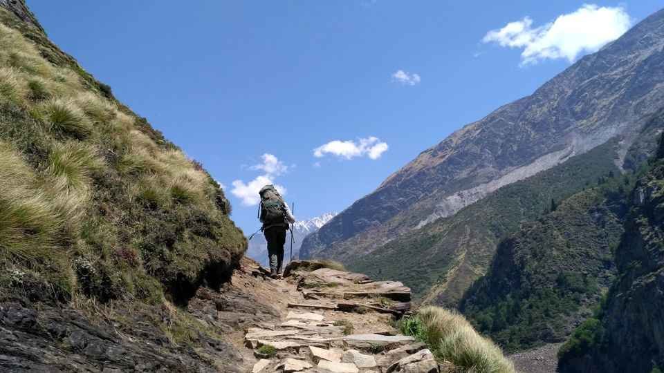
Milam Glacier Trek: Complete Guide
Trek Overview
The Milam Glacier trek is one of the most rewarding glacier treks in the Kumaon Himalayas, known for its peaceful landscapes, cultural heritage, and moderate difficulty .
Best Time to Trek
Day-by-Day Trek Itinerary
8-Day Standard Itinerary
| Day | Route | Distance | Time | Altitude | Overnight |
|---|---|---|---|---|---|
| 1 | Kathgodam → Munsiyari | 280 km drive | 10–12 hours | 2,200 m | Munsiyari |
| 2 | Munsiyari → Bilju (drive) → Milam Village | 5 km trek | 4–5 hours | 3,500 m | Milam Village |
| 3 | Milam Village → Milam Glacier → Milam Village | 6 km round | 4–5 hours | 4,250 m | Milam Village |
| 4 | Milam Village → Bilju (trek) → Munsiyari (drive) | 5 km + drive | 5–6 hours | 2,200 m | Munsiyari |
| 5 | Munsiyari → Kathgodam → Delhi | 280 km drive | 10–12 hours | – | – |
14-Day Extended Itinerary
For those seeking a more immersive experience:
| Day | Route | Distance |
|---|---|---|
| 1 | Delhi → Almora | 381 km drive |
| 2 | Almora → Munsiyari | Drive |
| 3 | Munsiyari → Daba → Lilam | Trek |
| 4 | Lilam → Bagudiyar | 13 km |
| 5 | Bagudiyar → Rilkot | 12 km |
| 6 | Rilkot → Milam Village | 15 km |
| 7 | Milam Village → Milam Glacier → Milam Village | 8 km round |
| 8 | Milam Village → Martoli/Burfu | Trek |
| 9 | Rest at Martoli | – |
| 10 | Martoli → Bagudiyar | 15 km |
| 11 | Bagudiyar → Lilam | 12 km |
| 12 | Lilam → Munsiyari | Trek |
| 13 | Munsiyari → Almora | Drive |
| 14 | Almora → Delhi | Drive |
Nanda Devi East Base Camp Trek
From Panchu and Ghangar villages (side valleys from the main route), there is a 6 km-long trek to the base camp of Nanda Devi East, India’s second-highest mountain at 7,816 m. This is a challenging side trip for experienced trekkers and requires additional days.
Weather and Best Time to Visit
Climate Overview
Milam Valley experiences a harsh alpine climate. The valley is accessible only during specific months due to heavy snowfall in winter.
Month-by-Month Guide
| Month | Season | Day Temp (°C) | Night Temp (°C) | Conditions | Trek Suitability |
|---|---|---|---|---|---|
| April | Spring | 5–12 | -5–2 | Snow melting, trails opening | ⭐ Good |
| May | Summer | 8–18 | 0–8 | Pleasant, clear skies | ⭐ Best |
| June | Summer | 10–20 | 3–10 | Warm, ideal for trekking | ⭐ Best |
| July | Monsoon | 10–16 | 5–10 | Heavy rain, landslides | ❌ Avoid |
| August | Monsoon | 10–16 | 5–10 | Heavy rain, slippery trails | ❌ Avoid |
| September | Autumn | 5–14 | 0–5 | Post-monsoon, clear | ⭐ Best |
| October | Autumn | 3–12 | -5–2 | Crisp, clear, valley closes | ⭐ Good |
| November–March | Winter | -5–8 | -15–-2 | Heavy snow, valley closed | ❌ Closed |
Best Time to Visit by Season
| Season | Months | Suitability | Conditions | Best For |
|---|---|---|---|---|
| Summer | May–June | ⭐ Best | 8°C–20°C, clear skies, meadows green | Trekking, photography, glacier views |
| Autumn | September–October | ⭐ Excellent | 3°C–14°C, crystal-clear skies | Photography, clear mountain views |
| Monsoon | July–August | ❌ Avoid | 10°C–16°C, heavy rainfall, landslides | Not recommended |
| Winter | November–April | ❌ Closed | Below freezing, heavy snow | Valley inaccessible |
Yarsagumba Season
The rare caterpillar fungus (Yarsagumba) is found only in May and June after the snow melts in the higher regions of the valley. This is when some Shaukas return to the valley for fungi expeditions.
Things to Do in Milam Valley
1. Milam Glacier Trek
The primary reason most visitors come to Milam Valley is to trek to the Milam Glacier, one of the largest glaciers in the Kumaon region.
Trek Details:
- Distance from Milam Village: ~3 km one way
- Duration: 3–4 hours round trip
- Altitude: 4,250 m
- Highlights: Source of the Gori Ganga River, views of Hardeol, Trisuli, and Nanda Ghoonti peaks
2. Explore the Abandoned Villages
The valley is dotted with ancient villages that tell the story of the region’s prosperous past.
3. Visit Martoli Village
Martoli is one of the most impressive abandoned villages in the valley. Its huge stone houses with slate roofs and intricately carved window and doorframes speak of the wealth and prosperity of its former inhabitants.
4. Nanda Devi East Base Camp Trek
For experienced trekkers, a side trek from Panchu and Ghangar villages leads to the base camp of Nanda Devi East (7,816 m), India’s second-highest peak.
Trek Distance: 6 km one way from the villages
5. Birdwatching
The valley is rich in Himalayan bird species, including the Himalayan Monal (state bird of Uttarakhand), Cheer Pheasant, Koklas Pheasant, and numerous other species.
Best Time: Early morning, especially during the summer months
6. Photography
Milam Valley is a photographer’s paradise:
- Best Spots: Milam Glacier viewpoint, Martoli village stone houses, Milam village ruins, Gori Ganga River valley, Panchachuli peaks from Munsiyari
- Best Time: Early morning for golden light; autumn for clearest skies
- Gear: Wide-angle lens for landscapes, telephoto lens for wildlife
7. Cultural Interaction
Interact with the descendants of the original Shauka inhabitants who return to the valley during the summer months. Learn about their traditional way of life, listen to stories of the ancient trade routes, and experience their warm hospitality.
Accommodation Options
In Munsiyari (Base Camp)
| Category | Price Range (per night) | Features |
|---|---|---|
| Mid-Range Hotels | ₹2,500 – ₹5,000 | Comfortable rooms, hot water, mountain views |
| Budget Hotels | ₹800 – ₹2,000 | Basic amenities, affordable |
| Homestays | ₹1,500 – ₹3,500 | Authentic Kumaoni experience, home-cooked food |
On the Trek
Important Notes on Accommodation
- As the inhabitants of the upper villages tend to move down the valley for the winter months, trekkers may find that food and accommodation are not available, especially after the festival of Diwali
- Most treks are organised through registered tour operators who arrange camping equipment and meals
- Carry your own sleeping bag for hygiene (though operators usually provide them)
- Book well in advance for peak trekking season (May–June, September–October)
Sample Itinerary (8 Days)
| Day | Route | Distance | Time | Overnight |
|---|---|---|---|---|
| 1 | Kathgodam → Munsiyari | 280 km drive | 10–12 hours | Munsiyari |
| 2 | Munsiyari → Bilju (drive) → Milam Village | 5 km trek | 4–5 hours | Milam Village |
| 3 | Milam Village → Milam Glacier → Milam Village | 6 km round | 4–5 hours | Milam Village |
| 4 | Rest/acclimatization day at Milam | – | – | Milam Village |
| 5 | Milam Village → Bilju (trek) → Munsiyari (drive) | 5 km + drive | 5–6 hours | Munsiyari |
| 6 | Munsiyari exploration | – | – | Munsiyari |
| 7 | Munsiyari → Kathgodam | 280 km drive | 10–12 hours | Train |
| 8 | Kathgodam → Delhi | Train | 7 hours | – |
Travel Tips and Important Information
Before You Go
- Permits Required: A permit is required to enter the Johar Valley, along with approval from the ITBP and clearance from the forest department. Book through registered tour operators who handle these formalities.
- Physical Fitness: The trek is moderate, covering ~60 km over 6–8 days. Prepare with regular walking and stair climbing for 4–6 weeks before.
- Medical Check-up: Consult your doctor before undertaking high-altitude trekking.
- Carry Cash: No ATMs on the trek; bring sufficient cash from Munsiyari.
- Check Weather: Avoid monsoon (July–August); the trek is closed in winter.
- Mobile Network: No mobile connectivity beyond Munsiyari. Inform family of your travel plans in advance.
During Your Trek
- Acclimatise Properly: Spend a night in Munsiyari (2,200 m) before starting the trek.
- Stay Hydrated: Drink plenty of water to prevent altitude sickness.
- Dress in Layers: Temperatures can change rapidly—layers allow adjustment.
- Start Early: Begin each day’s trek early to complete sections before afternoon weather changes.
- Hire Local Guides: Local guides are essential for navigation, safety, and cultural insights.
- Respect the Ruins: The abandoned villages are historically significant; do not damage or remove anything.
Safety Tips
- Altitude Awareness: Above 3,000 m, altitude sickness is possible. Stay hydrated, walk slowly, and descend if symptoms worsen.
- Road Safety: Mountain roads require patience; avoid night driving.
- Monsoon Travel: Avoid July–August due to landslide risk.
- Wildlife: The area is rich in wildlife; do not feed animals.
- Leave No Trace: Carry back all non-biodegradable waste.
Packing Checklist
| Category | Items |
|---|---|
| Clothing | Thermal inners, fleece jacket, down jacket, waterproof outer shell, trekking pants (2 pairs), woollen gloves, muffler, woolen cap, heavy woollen socks (4–5 pairs), sturdy trekking shoes |
| Gear | Trekking poles, headlamp/torch with extra batteries, power bank, reusable water bottle, water purification tablets |
| Health | Personal medications, first-aid kit, Diamox (consult doctor), ORS packets |
| Documents | Valid ID proof (Aadhaar/Passport), travel insurance, permit copies |
| Other | Thermal inners, fleece jacket, down jacket, waterproof outer shell, trekking pants (2 pairs), woollen gloves, muffler, woollen cap, heavy woollen socks (4–5 pairs), sturdy trekking shoes |
Photography Tips
- Best Spots: Milam Glacier viewpoint, Martoli village stone houses, Milam village ruins, Gori Ganga River valley
- Best Time: Early morning for golden light; autumn for clearest skies
- Camera Gear: Carry extra batteries—cold drains them quickly; telephoto lens for wildlife
Nearby Places to Visit
Frequently Asked Questions (FAQs)
Q1: What is Milam Valley famous for?
A: Milam Valley (also known as Johar Valley) is famous for being an ancient trade route to Tibet, its abandoned villages (especially Milam and Martoli), the Milam Glacier trek, the Shauka (Bhotiya) culture, and as the birthplace of legendary explorers Nain Singh Rawat and Krishna Singh Rawat.
Q2: What is the best time to visit Milam Valley?
A: The best time to visit is May to June (summer) and September to October (autumn). The valley remains closed from November to April due to heavy snowfall.
Q3: How far is Milam Valley from Delhi?
A: The distance from Delhi to Munsiyari (base camp) is approximately 600 km, with a travel time of 14–16 hours by road.
Q4: How do I reach Milam Valley?
A: By road to Munsiyari (via Kathgodam, Almora, and Bageshwar), then a 59 km trek to Milam Village. The nearest railway station is Kathgodam (~280 km), and the nearest airport is Pantnagar (~435 km).
Q5: What is the altitude of Milam Village?
A: Milam Village is situated at approximately 3,500 meters (11,500 feet) above sea level.
Q6: What is the Milam Glacier altitude?
A: The Milam Glacier is located at approximately 4,250 meters (13,944 feet) above sea level.
Q7: What is the Milam Glacier trek distance?
A: The trek from Munsiyari to Milam Glacier is approximately 59 km one way, taking 6–8 days round trip.
Q8: Is the Milam Glacier trek difficult?
A: The trek is considered moderate in difficulty, suitable for trekkers with basic fitness and prior walking experience.
Q9: What is the Munsiari-Bugdiar-Milam Road (MBMR)?
A: The MBMR is a road being constructed by the BRO as part of the India–China Border Roads, with an expected completion date of March 2026. It will connect Milam village with Munsiyari.
Q10: What is the Shauka tribe?
A: The Shauka (also called Johari Shauka or Bhotiya) are the indigenous people of the Johar Valley. They are of Tibeto-Burmese origin, traditionally traders on the Indo-Tibetan route, and followers of Hinduism with Goddess Nanda Devi as their main deity.
Q11: What is Yarsagumba?
A: Yarsagumba (caterpillar fungus) is a rare insect-fungus fusion found in the high-altitude regions of the Himalayas. It is highly prized in traditional Chinese medicine and can fetch over US$20,000 per kg.
Q12: Why is Milam called a ghost village?
A: After the 1962 Sino-Indian War, the borders were sealed, and the Shauka community was evacuated. Milam, once home to 400 families, now stands mostly abandoned, with only a handful of descendants returning during the summer months.
Q13: Who were the pundit-explorers from Milam?
A: Nain Singh Rawat (C.I.E.) and Krishna Singh Rawat (Rai Bahadur) were legendary Indian explorers from Milam who mapped vast territories of Tibet in the 19th century.
Q14: Is there a mobile network in Milam Valley?
A: No, there is no mobile connectivity beyond Munsiyari. BSNL may work in some pockets, but it is unreliable. Inform family of your travel plans in advance.
Q15: Are there ATMs in Milam Valley?
A: ATMs are available in Munsiyari but not on the trek. Carry sufficient cash before starting the trek.
Plan Your Milam Valley Adventure with Discover Uttarakhand
At Discover Uttarakhand, we’ve been organising unforgettable Himalayan journeys across Devbhoomi since 1997. As a trusted local operator with deep knowledge of the Kumaon region and the Johar Valley, we offer:
- ✅ Milam Glacier Trek packages (8 to 14 days)
- ✅ Complete permit assistance (ITBP and forest department clearances)
- ✅ Experienced local guides familiar with the Johar Valley and Shauka culture
- ✅ Comfortable transport from Kathgodam to Munsiyari
- ✅ Camping equipment (tents, sleeping bags, meals)
- ✅ Homestay arrangements in Munsiyari
- ✅ 24/7 customer support throughout your journey
Recommended Milam Valley Packages
| Package | Duration | Starting Point | Highlights |
|---|---|---|---|
| Milam Valley Trek (8 Days) | 7 Nights / 8 Days | Kathgodam | Lilam, Milam Village, Milam Glacier |
| Milam Glacier Trek (14 Days) | 13 Nights / 14 Days | Delhi | Full circuit, Martoli, Burfu, Nanda Devi East base |
| Johar Valley Explorer | 5 Nights / 6 Days | Kathgodam | Munsiyari, Tribal Museum, Panchachuli views |
Book your Milam Valley journey today and walk through history in the land of the Shauka traders.
📞 Call / WhatsApp: +91-9997187178, 9760222178, 8171977178
📍 Visit Our Office: Himalayan Colony, opposite DSVV, Haripur Kalan, Haridwar, Motichur Range, Uttarakhand 249411
🌐 Website: www.discover-uttarakhand.com
📧 Email: info@discover-uttarakhand.com
Discover Uttarakhand – Your Local Partner for Unforgettable Himalayan Journeys Since 1997 🏔️