Introduction: The Ghost Village Frozen in Time
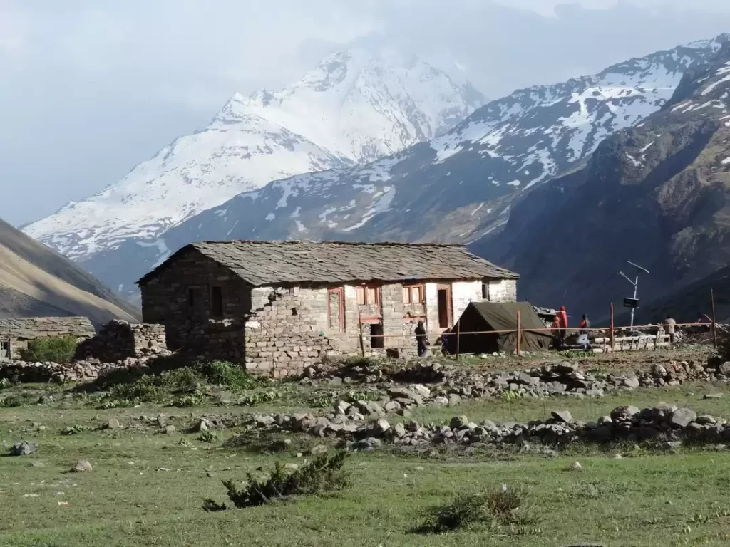
Deep in the remote Johar Valley of Uttarakhand’s Pithoragarh district, at an altitude of 3,434 meters (11,266 feet), lies Milam—a village that whispers stories of a glorious past. Once a bustling trade hub with over 400 families, Milam was the first Indian village on the ancient trans-Himalayan trade route to Tibet. Today, it stands as a hauntingly beautiful ghost village, with stone houses, broken walls, and crumpled roofs bearing silent witness to a bygone era.
The village is situated at the snout of the Milam Glacier, the source of the Goriganga River, and serves as the base for one of the most challenging and rewarding treks in the Kumaon Himalayas. For decades after the Sino-Indian War of 1962, Milam lay completely abandoned, its trade routes sealed and its people resettled in lower valleys. The valley reopened in 1994, and today, a handful of descendants return during the summer months to cultivate medicinal plants and high-altitude crops, while trekkers venture here to experience the raw beauty of the Himalayas and walk through history.
Whether you are a seasoned trekker seeking high-altitude adventure, a history enthusiast tracing the footsteps of legendary pundit-explorers, or a traveller drawn to the romance of abandoned villages frozen in time, Milam offers an experience unlike any other in the Indian Himalayas.
Key Information at a Glance:
History: The Glorious Trade Hub of the Johar Valley
The Ancient Silk Route Connection
Milam’s history is inseparable from the ancient trans-Himalayan trade routes that connected India with Tibet. The village was the first Indian settlement on a major trade route that crossed high mountain passes—Unta Dhura, Jandi Dhura, and Kingribingri Dhura—to reach Gyanima Mandi in Tibet.
At its peak in the early 1900s, Milam was a thriving trade centre where Shauka tribesmen (also known as Bhotiyas), traditionally farmers and shepherds, became successful and prosperous merchants. They travelled over 1,500 km east to Kolkata to procure silk, spices, and other goods to trade with Tibet.
Tibetan merchants would make the reverse journey with their yaks and other livestock to reach Milam, where they traded wool, salt, pashmina, borax, and precious stones for rice, cotton clothes, jaggery, and sugar.
A Village of Legends
Milam was so large and prosperous that local legends claim that newlywed brides, after fetching water from nearby springs, would often lose their way in the maze-like alleys and end up in the wrong house. There’s even a spot on the cliff above the village, still marked by a flag, from where people would loudly call the lost women and give them directions.
The Pundit-Explorers of Milam
Milam holds a distinguished place in the history of Himalayan exploration. The village is the birthplace of two legendary Indian explorers:
- Nain Singh Rawat (1830–1895): Awarded the C.I.E. by the British Raj, he was one of the first surveyors to fix the location of Lhasa and map vast territories of Tibet on foot, walking 1,580 miles and counting every step.
- Krishna Singh Rawat (1850–1921): Awarded the title of Rai Bahadur, he was the first to map the Ramgarh crater on a finer scale.
These “pundit-explorers” were trained by the British to survey the forbidden lands of Tibet disguised as pilgrims, and their contributions to the mapping of Central Asia remain unparalleled.
The 1962 Closure and Abandonment
The Sino-Indian War of 1962 changed everything. After a series of failed dialogues between the two countries, the borders were sealed, and platoons of Indian soldiers were deployed in the Johar Valley. The villages were evacuated, and the Shaukas moved to lower areas—primarily Munsiyari—where they were offered land and jobs in the government. The trade with Tibet came to an abrupt end.
Milam, once home to 400 families, became a ghost village.
The Slow Return
The valley finally reopened in 1994, but with strict rules. Even today, all visitors are carefully monitored, with bags searched and cameras checked. A permit is required, along with approval from the ITBP and clearance from the forest department.
In summer months, very few people—mostly descendants of the original inhabitants—return to Milam to cultivate medicinal plants, high-altitude buckwheat, and Jambhu. Stones engraved with Tibetan text are still commonly found in the abandoned villages, a testament to this thriving trade route.
Geography and Location
Geographic Coordinates
Location
Milam is situated in the Johar Valley of the Pithoragarh district, in the Kumaon region of the Himalayas. The village lies on the banks of the Goriganga River, which originates from the Milam Glacier. It is approximately:
- 60 km (trekking distance) from Munsiyari
- 24 km from Martoli (another abandoned village)
- 15 km from the snout of Milam Glacier
The Milam Glacier
The Milam Glacier is a major Himalayan glacier, covering approximately 37 square kilometres and stretching 16 km in length. It ranges in elevation from about 5,500 meters at its origin to 3,870 meters at its snout.
Situated on the south-facing slope of the main Great Himalaya range, the glacier is fed by several subsidiary glaciers from peaks like Trishuli, Hardeol, Nanda Gond, and Nanda Pal.
Milam Valley
The Milam Valley is part of the Nanda Devi Biosphere Reserve, a UNESCO World Heritage Site known for its exceptional biodiversity. A 2011 study documented 86 species of spiders under 39 genera and 16 families in the valley, indicating the richness of the ecosystem.
Flora and Fauna
Forests and Vegetation
| Forest Type | Dominant Species | Characteristics |
|---|---|---|
| Temperate Forests | Oak, Rhododendron | Dense canopies, spring blooms |
| Coniferous Forests | Pine, Deodar | Scented air, tall evergreen trees |
| Alpine Meadows | Grasses, herbs, wildflowers | High-altitude pastures |
The herb-rich meadows surrounding the villages are known for edible plants like wild spinach and wild fern, which are local delicacies cooked with oil and spices.
Yarsagumba – The Caterpillar Fungus
About a decade ago, a very rare fungus was discovered in the high-altitude valley. Commonly known as Yarsagumba, or caterpillar fungus, this unique insect-fungus fusion is famous in traditional Chinese medicine for its supposed libido-boosting powers as well as a remedy for lung- and kidney-related diseases.
Only found in May and June after the snow melts in the higher regions, 1 kg of Yarsagumba can fetch more than US$20,000. Although the trade is illegal in India, some Shaukas use these villages as a base camp for their fungi expeditions, making it a significant (though controversial) source of income.
Wildlife
The region supports a variety of Himalayan wildlife:
| Species | Description |
|---|---|
| Himalayan Black Bear | Found in forested areas |
| Musk Deer | Endangered species, known for its prized musk |
| Himalayan Tahr | Large mountain goat |
| Bharal (Blue Sheep) | Agile mountain goat |
| Snow Leopard | The elusive “ghost of the mountains” (higher altitudes) |
Birdlife
The forests around Milam are home to various Himalayan bird species, including the Himalayan Monal (state bird of Uttarakhand), pheasants, and vultures.
How to Reach Milam Village
By Air
Nearest Airport: Pantnagar Airport (approximately 435 km from Milam)
| Details | Information |
|---|---|
| Distance | ~435 km |
| Travel Time | 10–12 hours by taxi to Munsiyari |
| Airlines | Regular flights from Delhi to Pantnagar (approx. 1 hour) |
| Onward Travel | Taxi from airport to Munsiyari, then trek |
By Train
Nearest Railway Stations:
| Station | Distance | Travel Time | Connectivity |
|---|---|---|---|
| Tanakpur | 331 km | 10–12 hours by road | Alternative option |
| Kathgodam | ~350 km | 10–12 hours by road | Most preferred, well-connected from Delhi |
Popular Train from Delhi to Kathgodam:
| Train Name | From Delhi | Departure | Arrival (Kathgodam) | Duration |
|---|---|---|---|---|
| Ranikhet Express | Delhi | 10:05 PM | 5:05 AM | 7 hours |
From the railway station, taxis are available for the 10–12-hour drive to Munsiyari.
By Road to Munsiyari (Base Camp)
Munsiyari is the last motorable point and the traditional base for the Milam trek.
| Starting Point | Distance | Travel Time | Route |
|---|---|---|---|
| Delhi | ~700 km | 16–18 hours | Delhi → Hapur → Moradabad → Rampur → Haldwani → Kathgodam → Almora → Thal → Munsiyari |
| Kathgodam | ~350 km | 10–12 hours | Kathgodam → Bhimtal → Almora → Thal → Munsiyari |
| Almora | ~200 km | 7–8 hours | Almora → Thal → Munsiyari |
Road Conditions: The roads are winding but generally good. The final stretch from Thal to Munsiyari is scenic but has sharp bends.
Munsiyari to Milam – The Trek Route
The trek from Munsiyari to Milam is the primary access route and is a moderately challenging multi-day trek.
Traditional Trek Route:
Total Trek Distance: Approximately 65–70 km one way
Munsiyari to Milam Road (MBMR): A motorable road being constructed by BRO with an expected completion date of March 2026 will provide access to Milam village and the glacier from Munsiyari. However, even after completion, trekking remains the preferred mode for experiencing the valley.
Distances from Major Cities
| City | Distance (km) |
|---|---|
| Delhi | ~700 |
| Kathgodam | ~350 |
| Almora | ~200 |
| Munsiyari | 0 (base) |
| Lilam | ~20 km (trek) |
| Bagudiyar | ~32 km (trek) |
| Raikot | ~44 km (trek) |
| Martoli | ~54 km (trek) |
| Milam Village | ~70 km (trek) |
Trekking to Milam Village
Difficulty Level
The Milam trek is considered moderate to challenging. It involves:
- Long daily distances (12–15 km per day)
- Gradual altitude gain (from 2,200 m to 3,500 m)
- Mixed terrain (forest trails, river crossings, steep climbs)
- Basic camping facilities
Best For: Experienced trekkers, adventure enthusiasts, and those with good physical fitness
Complete Trek Itinerary (14 Days)
| Day | Route | Distance | Trek Time | Altitude | Overnight |
|---|---|---|---|---|---|
| 1 | Delhi → Kathgodam (train) | 350 km | 7 hours | – | Train |
| 2 | Kathgodam → Munsiyari (drive) | 350 km | 10–12 hours | 2,200 m | Hotel |
| 3 | Munsiyari → Darkot → Lilam | 13 km | 5–6 hours | 2,300 m | Camp |
| 4 | Lilam → Bagudiyar | 12 km | 5–6 hours | 2,500 m | Camp |
| 5 | Bagudiyar → Raikot | 12 km | 4–5 hours | 3,200 m | Camp |
| 6 | Raikot → Martoli | 10 km | 4–5 hours | 3,300 m | Camp |
| 7 | Martoli → Burfu → Milam | 15 km | 6–7 hours | 3,434 m | Camp |
| 8 | Rest/Acclimatization day at Milam | – | – | 3,434 m | Camp |
| 9 | Milam → Milam Glacier → Milam | 16 km round | 6–7 hours | 3,870–4,242 m | Camp |
| 10 | Milam → Burfu → Martoli | 15 km | 5–6 hours | 3,300 m | Camp |
| 11 | Martoli → Raikot | 10 km | 4–5 hours | 3,200 m | Camp |
| 12 | Raikot → Bagudiyar | 12 km | 5–6 hours | 2,500 m | Camp |
| 13 | Bagudiyar → Lilam → Munsiyari | 20 km | 7–8 hours | 2,200 m | Guesthouse |
| 14 | Munsiyari → Kathgodam → Delhi | 350 km | 10–12 hours | – | – |
Milam Glacier Trek
From Milam village, the glacier is approximately 5 km (one way), taking 2–3 hours to reach. The glacier sits at an altitude of 4,242 meters and offers stunning views of peaks like Rishi Pahar (6,692 m), Hardeol (7,151 m), and Trishuli (7,074 m).
Permits Required
- Inner Line Permit (ILP): Required for the Johar Valley due to proximity to the Tibet border
- Forest Permit: Required for trekking in the Nanda Devi Biosphere Reserve
- ITBP Clearance: Additional clearance from the Indo-Tibetan Border Police
Permits are typically arranged through registered tour operators in Munsiyari.
Nearby Places to Visit
Munsiyari – The Base Camp
Munsiyari is the gateway to the Johar Valley and the starting point for the Milam trek. Known as “Mini Kashmir,” it offers stunning views of the Panchachuli peaks and serves as a base for several treks, including Milam, Ralam, and Nanda Devi.
Martoli – The Crown of the Johar Valley
Martoli is one of the most impressive abandoned villages in the valley. Its huge stone houses with slate roofs and intricately carved window and doorframes speak of the wealth and prosperity of its former inhabitants. The village offers breathtaking views of the surrounding peaks and is a highlight of the trek.
Nanda Devi East Base Camp
From the Lwan Valley, a side trek leads to the base camp of Nanda Devi East (7,434 m), India’s second-highest mountain. This challenging side trip is for experienced trekkers and requires additional days.
Weather and Best Time to Visit
Climate Overview
Milam experiences a harsh alpine climate. The valley is accessible only during the summer months, as winter brings heavy snowfall and sub-zero temperatures.
Trekking Season by Month
| Month | Day Temp (°C) | Night Temp (°C) | Conditions | Trek Suitability |
|---|---|---|---|---|
| May | 10–18 | 0–5 | Snow melting, trails opening | ⭐ Good |
| June | 15–22 | 3–8 | Pleasant, clear skies | ⭐ Best |
| July | 12–20 | 5–10 | Monsoon, heavy rain, landslide risk | ❌ Avoid |
| August | 12–20 | 5–10 | Monsoon, continued rain | ❌ Avoid |
| September | 10–18 | 0–5 | Post-monsoon, clear | ⭐ Best |
| October | 5–15 | -5–0 | Cold, clear, trails close mid-October | ⭐ Good |
| November–April | -5–10 | -15–-5 | Heavy snow, the valley is inaccessible | ❌ Closed |
Best Time to Trek
| Season | Months | Suitability | Conditions |
|---|---|---|---|
| Pre-Monsoon | May–June | ⭐ Best | Pleasant days, clear skies, wildflowers begin to bloom |
| Post-Monsoon | September–October | ⭐ Excellent | Crystal-clear skies, crisp air, best mountain views |
Why Avoid Monsoon
The monsoon months (July–August) bring heavy rainfall to the Kumaon Himalayas, leading to:
- Landslides that can block the approach road to Munsiyari
- Slippery and dangerous trekking trails
- Leeches in the lower forested sections
- Cloud cover obscuring mountain views
Winter Closure
The valley closes from November to April due to heavy snowfall. The inhabitants move down to lower altitudes, and the trekking routes become impassable.
Local Cuisine: What to Eat
Dining options in Milam are extremely limited. Trekkers must carry their own food supplies or rely on basic meals provided by tour operators.
Local Delicacies (When Available)
What Trekkers Should Carry
- Ready-to-eat meals (MREs)
- Energy bars, nuts, and dry fruits
- Instant noodles, soups, and oats
- Tea and coffee supplies
- Water purification tablets (natural water sources are available)
Dining Tips
- All meals during the trek are typically provided by the trek operator
- Carry sufficient snacks for the journey
- Water is available from streams—always purify before drinking
Accommodation Options
During the Trek
Accommodation on the Milam trek is exclusively camping in tents.
| Location | Type | Facilities |
|---|---|---|
| Lilam | Camping | Basic camp, river nearby |
| Bagudiyar | Camping | Forest setting |
| Raikot | Camping | Mountain views |
| Martoli | Camping | Near abandoned village |
| Milam | Camping | Near the ghost village |
In Munsiyari (Before/After Trek)
| Category | Price Range (per night) | Examples | Features |
|---|---|---|---|
| Mid-Range Hotels | ₹2,500 – ₹5,000 | Hotel Milam Inn, Vikramaditya Resort | Comfortable rooms, hot water, mountain views |
| Budget Hotels | ₹800 – ₹2,000 | Local guesthouses | Basic amenities, affordable |
| Homestays | ₹1,500 – ₹3,500 | Various family-run properties | Authentic Kumaoni experience |
Booking Tips
- The Milam trek requires advance booking through registered tour operators
- Tents and camping equipment are typically provided by the operator
- Carry personal sleeping bags for hygiene (though operators usually provide them)
- Book accommodations in Munsiyari in advance during peak season (May–June, September–October)
Essential Packing List
Clothing
- Thermal innerwear (top and bottom) – multiple pairs
- Fleece jacket and heavy woollen sweater
- Down jacket for high-altitude cold
- Waterproof outer shell / windproof jacket
- Trekking pants (2–3 pairs, quick-dry recommended)
- Woollen gloves, muffler, and woollen cap
- Heavy woollen socks (3–4 pairs)
- Sturdy, broken-in trekking shoes with good grip (waterproof recommended)
- Comfortable camp shoes/sandals for evenings
Trekking Gear
- Trekking poles (essential for stability)
- Headlamp or torch with extra batteries
- Power bank (no electricity on the trail)
- Reusable water bottle (insulated recommended)
- Water purification tablets or a filter
- Backpack (50–70 litres) with rain cover
- Daypack (optional for shorter sections)
Health and First Aid
- Personal medications with prescription (enough for entire trip + extra days)
- First-aid kit with bandages, antiseptics, pain relievers, and anti-diarrheal
- Altitude sickness medication (consult doctor)
- Portable oxygen can (recommended)
- Basic toiletries, wet wipes, and hand sanitiser
- Moisturiser and lip balm (high altitude causes dryness)
Documents and Cash
- Valid ID proof (Aadhaar/Passport/Voter ID)
- Permits (arranged by tour operator)
- Travel insurance documents
- Cash (no ATMs on the trail; carry sufficient from Munsiyari)
Food and Snacks
- Energy bars, dry fruits, nuts
- Electrolyte sachets
- Glucose for quick energy
- Chocolate for instant energy
Travel Tips and Important Information
Before You Go
- Physical Fitness: The Milam trek requires good physical fitness. Prepare with regular walking, jogging, and stair climbing 4–6 weeks before the trek.
- Medical Check-up: Consult your doctor before undertaking high-altitude trekking, especially if you have heart or respiratory conditions.
- Book Through Registered Operators: The Milam trek requires permits and local knowledge. Always book through registered tour operators in Munsiyari.
- Carry Cash: There are no ATMs on the trail. Bring sufficient cash from Munsiyari.
- Check Weather: Avoid monsoon (July–August) and verify conditions before departure.
During the Trek
- Acclimatise Properly: The itinerary includes rest days at Milam for acclimatisation. Do not skip them.
- Stay Hydrated: Drink plenty of water to prevent altitude sickness. Purify water from natural sources.
- Dress in Layers: Temperatures can change rapidly—layers allow adjustment throughout the day.
- Start Early: Begin daily treks early to complete sections before afternoon weather changes.
- Listen to Your Guide: Local guides know the terrain and weather patterns. Follow their instructions.
Health and Safety
- Altitude Sickness: Symptoms include headache, nausea, and breathlessness. If symptoms worsen, descend immediately.
- AMC (Acute Mountain Sickness): At altitudes above 3,500 m, AMS is possible. The itinerary includes acclimatisation days.
- Emergency Procedures: Tour operators carry satellite communication devices for emergencies.
- Medical Facilities: The nearest medical facilities are in Munsiyari.
Respect the Environment
- Leave No Trace: Carry back all non-biodegradable waste.
- Respect Abandoned Structures: The villages are historically significant; do not damage or remove anything.
- Photography: Ask permission before photographing local inhabitants or military installations.
Packing Tips
- Break in trekking shoes before the trek
- Pack light but warm—weight matters on long treks
- Carry extra batteries—cold drains them quickly
- Use a waterproof backpack cover
Frequently Asked Questions (FAQs)
Q1: Why is Milam Village famous?
A: Milam is famous as a ghost village that was once a thriving trade hub on the ancient Silk Route to Tibet. It is the birthplace of legendary pundit-explorers Nain Singh and Krishna Singh Rawat and serves as the base for the Milam Glacier trek.
Q2: What is the best time to visit Milam Village?
A: The best time to visit is May to June (pre-monsoon) and September to October (post-monsoon). The valley remains closed from November to April due to heavy snowfall.
Q3: How far is Milam Village from Delhi?
A: The distance is approximately 700 km by road to Munsiyari, followed by a 60–70 km trek to Milam village. The total journey takes 5–7 days one way.
Q4: How do I reach Milam Village?
A: By road to Munsiyari (from Delhi via Kathgodam), then a 6–7 day trek through Lilam, Bagudiyar, Raikot, Martoli, and Burfu.
Q5: What is the altitude of Milam Village?
A: Milam is situated at an altitude of approximately 3,434 meters (11,266 feet) above sea level.
Q6: Is the Milam trek difficult?
A: The trek is moderate to challenging. It involves long daily distances (12–15 km), altitude gain up to 4,242 m, and mixed terrain. Good physical fitness is required.
Q7: Do I need a permit for Milam?
A: Yes, an Inner Line Permit (ILP) is required as the village is close to the Tibetan border. Permits are typically arranged through registered tour operators in Munsiyari.
Q8: Is Milam Village inhabited?
A: Milam is mostly a ghost village. Very few people—descendants of the original inhabitants—return during summer months to cultivate medicinal plants and high-altitude crops. The village is abandoned in winter.
Q9: What is the Milam Glacier?
A: The Milam Glacier is a 16 km long glacier covering 37 sq km, the source of the Goriganga River. It sits at approximately 3,870–4,242 meters and is a 5 km trek from Milam village.
Q10: What is the distance from Munsiyari to Milam?
A: The trekking distance from Munsiyari to Milam is approximately 60–70 km, typically covered in 6–7 days.
Q11: Can I drive to Milam Village?
A: A motorable road (MBMR) is being constructed and expected to be completed by March 2026. However, trekking remains the preferred mode for experiencing the valley.
Q12: What is the Martoli village?
A: Martoli is another abandoned village on the trek route, known for its impressive stone houses with intricately carved doorframes. It is considered the “crown” of the Johar Valley’s abandoned villages.
Q13: Who were the pundit-explorers from Milam?
A: Nain Singh Rawat (C.I.E.) and Krishna Singh Rawat (Rai Bahadur) were legendary Indian explorers from Milam who mapped vast territories of Tibet in the 19th century.
Q14: What is the Nanda Devi East Base Camp?
A: The base camp of Nanda Devi East (7,434 m) is accessible via a side trek from the Lwan Valley. It is a challenging side trip for experienced trekkers.
Q15: Is Milam safe for solo trekkers?
A: Solo trekking is not recommended due to the remote location, altitude, permit requirements, and lack of infrastructure. It is strongly advised to trek with registered groups or experienced guides.
Plan Your Milam Adventure with Discover Uttarakhand
At Discover Uttarakhand, we’ve been organising unforgettable Himalayan journeys across Devbhoomi since 1997. As a trusted local operator with deep knowledge of the Kumaon region, we offer:
- ✅ Milam Glacier Trek packages (14 to 18 days)
- ✅ Complete permit assistance (Inner Line Permit, forest permits)
- ✅ Experienced local guides familiar with the Johar Valley
- ✅ Comfortable transport from Kathgodam to Munsiyari
- ✅ Camping equipment (tents, sleeping bags, meals)
- ✅ Safety protocols, including satellite communication and first-aid kits
- ✅ 24/7 customer support throughout your journey
Recommended Milam Packages
| Package | Duration | Starting Point | Highlights |
|---|---|---|---|
| Milam Village Trek | 12 Nights / 13 Days | Kathgodam | Lilam, Bagudiyar, Raikot, Martoli, Milam Village |
| Milam Glacier Trek | 14 Nights / 15 Days | Kathgodam | Full trek including Milam Glacier snout |
| Nanda Devi Base Camp with Milam | 18 Nights / 19 Days | Kathgodam | Extended trek to Nanda Devi East Base Camp |
Book your Milam trek today and walk through history in the lost villages of the Johar Valley.
📞 Call / WhatsApp: +91-9997187178, 9760222178, 8171977178
📍 Visit Our Office: Himalayan Colony, opposite DSVV, Haripur Kalan, Haridwar, Motichur Range, Uttarakhand 249411
🌐 Website: www.discover-uttarakhand.com
📧 Email: info@discover-uttarakhand.com
Discover Uttarakhand – Your Local Partner for Unforgettable Himalayan Journeys Since 1997 🏔️