Overview: The Serpent’s Peak
Tucked away in the Jaunpur Range of the Tehri Garhwal district, Nag Tibba is not just a destination; it is a journey into the soul of the lower Himalayas and a perfect weekend escape for trekkers of all levels.
Often referred to as the “Serpent’s Peak”, this magnificent summit is the highest peak in the Lesser Himalayan region of the Garhwal Division, standing tall at 3,022 metres (9,915 feet). Located just 57 km from Mussoorie and about 85–100 km from Dehradun, Nag Tibba is renowned as one of the most accessible and rewarding weekend treks in Uttarakhand.
What makes Nag Tibba truly special is its extraordinary diversity—from the ancient temple dedicated to Nag Devta (the Serpent God) at the summit to the dense oak, rhododendron, and deodar forests that line the trail, from the 360-degree panoramic views of snow-capped peaks like Bandarpoonch, Swargarohini, and Gangotri to the rich Himalayan wildlife that inhabits the region.
The name “Nag Tibba” is derived from “Nag” (serpent) and “Tibba” (a local Garhwali word for hill or peak), meaning “the abode of the Snake God”. The mountain is believed to be the dwelling place of Nag Devta, and local villagers visit the summit temple to offer prayers for the protection of their cattle.
The journey to Nag Tibba, which begins from the base village of Pantwari, is an accessible yet profoundly rewarding adventure through terraced fields, sacred forests, and the majestic Himalayan wilderness. It offers a profound sense of peace, spiritual connection, and a deep appreciation for the rich cultural heritage of Uttarakhand.
Key Information at a Glance
| Aspect | Details |
|---|---|
| Location | Jaunpur Range, Tehri Garhwal District, Uttarakhand |
| Type | Mountain Peak / Trekking Destination |
| Parent Range | Garhwal Himalaya (Lesser Himalayas) |
| Elevation | 3,022 m (9,915 ft) |
| Coordinates | 30°35′11″N 78°9′4″E / 30.58639°N 78.15111°E |
| Nearest City | New Tehri / Mussoorie |
| Base Village | Pantwari Village (~1,350–1,400 m) |
| Trek Distance | ~10 km one way (Pantwari to summit) |
| Trek Duration | 2 Days / 1 Night (standard) |
| Trek Difficulty | Easy to Moderate (Beginner-friendly) |
| Best Time to Visit | October–March (clear weather) & April–June (mild conditions) |
| Official Language | Hindi |
| Regional Language | Garhwali |
| Vehicle Registration Code | UK-09 (Tehri Garhwal) |
| Nearest Airport | Jolly Grant Airport, Dehradun (~96 km) |
| Nearest Railway Station | Dehradun Railway Station (~73 km) |
| Known For | Nag Devta Temple, 360° Himalayan Views, Weekend Trek, Winter Snow Trek |
History of Nag Tibba
Ancient Roots in Serpent Worship
Nag Tibba has a history deeply rooted in the ancient serpent worship traditions of the Garhwal Himalayas. Snakes have always held an important status in Hindu religion and mythology. According to Hindu mythology, snakes are considered the representation of rebirth, death, and mortality, due to their shedding of skin and being symbolically “reborn”. The tradition of Nag Devta worship is ancient in the Garhwal hills, and the serpent deity is associated with fertility, protection, and rain.
The Name and Its Meaning
The mountain is believed to be the abode of Nag Devta (God of Snakes), from which it borrows the first part of its name. “Tibba” is a local word for hill or peak. Together, “Nag Tibba” means “the place or abode of the Snake God”.
The Nag Tibba Range
Nag Tibba lends its name to the Nag Tibba Range, which is one of the three principal ranges of the Lesser Himalayas, along with the Dhauladhar and the Pir Panjal ranges, which branch off from the Great Himalayas. The range forms a distinct fold in Himalayan geography and runs southwest from the Great Himalayas.
The Temple of Nag Devta
A small temple dedicated to Nag Devta sits at the summit — one of the first things trekkers encounter at the top after the climb. Local villagers from the surrounding area make regular offerings at the summit temple, seeking protection for their cattle and prosperity for their communities. For the villagers in this part of the mountains, Nag Devta is the protector of their cattle and sheep. Domesticated animals are their biggest assets, and Nag Devta is their protector.
The Legacy of the Trek
Nag Tibba has been a popular trekking destination for decades. The trek is mentioned in the famous book ‘7 Years in Tibet’ by Austrian climber Heinrich Harrer, which chronicles his escape from a British jail into Tibet. The trek’s proximity to Mussoorie and Dehradun has made it an ideal weekend getaway for generations of trekkers, and it continues to be one of the most popular beginner treks in the Indian Himalayas.
Geography of Nag Tibba
Location and Topography
Nag Tibba is situated at an elevation of 3,022 metres (9,915 feet) above sea level in the Jaunpur Range of the Tehri Garhwal district, Uttarakhand. The peak is located 16 km from Landour cantonment, 57 km from Mussoorie, and 148 km from New Tehri.
| Feature | Details |
|---|---|
| Location | Jaunpur Range, Tehri Garhwal district, Uttarakhand |
| Coordinates | 30°35′11″N 78°9′4″E |
| Elevation | 3,022 m (9,915 ft) |
| Terrain | Ridge peak, forests, meadows, summit |
| Base Village | Pantwari (~1,350–1,400 m) |
| Base Camp | Khatian Campsite (~2,265 m) |
| Distance from Dehradun | ~85–100 km |
| Distance from Mussoorie | ~57 km |
The Himalayan Panorama
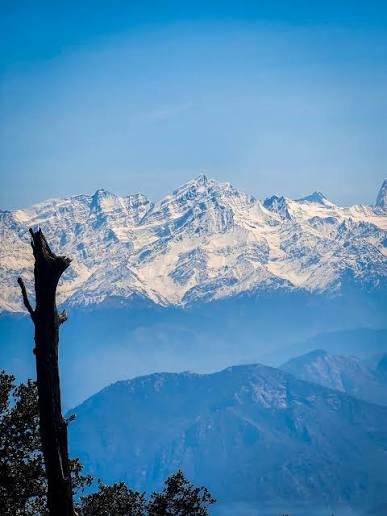
The summit of Nag Tibba offers breathtaking panoramic views of the surrounding Himalayan ranges, including the snow-capped peaks of Bandarpoonch, Gangotri, Swargarohini, Srikantha, Kala Nag, Kedarkantha, and Black Peak. The 360-degree vista showcases the transition from lower foothills to higher alpine zones. From the summit, one can see the entire Bandarpoonch range of the Great Indian Himalayas towards the Yamunotri side.
Major Landmarks and Valleys
- Pantwari Village – The starting point of the trek, a small village in Tehri Garhwal
- Khatian Campsite – The base camp at ~2,265 m, surrounded by dense forests
- Nag Tibba Temple – The small shrine dedicated to Nag Devta at the summit
- The Goat Village – An initiative started to sustain the Himalayan village’s way of living
Flora and Fauna
Flora
Nag Tibba is blessed with extraordinary biodiversity, with the trail passing through dense oak, rhododendron, and deodar forests that are home to a wide variety of Himalayan flora.
Key Tree Species:
- Oak (Quercus spp.) – Dominant species, forming the main canopy of the forest
- Rhododendron (Burans) – Adding vibrant colour to the trail, especially in spring
- Deodar (Cedrus deodara) – Found in the higher reaches
- Pine (Pinus roxburghii) – Present in the lower elevations
- Seasonal Wildflowers – The meadows bloom with vibrant wildflowers in spring and summer
The trail passes through terraced fields and hill slopes dotted with Bauhinia trees with their purple blossoms.
Fauna
Nag Tibba is a nature lover’s paradise, home to a remarkable variety of Himalayan wildlife. The forest is a protected area, making it a haven for wildlife and birdwatchers.
Mammals:
- Himalayan Leopards – Present in the forested areas
- Himalayan Black Bears – Found in the higher reaches
- Deer – Various species found in the region
- Langurs – Commonly seen in the forests
- Mountain Goats – More likely to be encountered than fellow trekkers on the Devalsari route
Birds:
- Himalayan Woodpecker – Frequently spotted in the forest
- Warblers – Common along the trail
- Barbets – Present in the forest
- Various Himalayan Birds – The region is rich in avian diversity
The flora and fauna of the Nag Tibba region act mutually to sustain the forest ecology, food chain, and local climate.
Protected Areas
| Protected Area | Type | Significance |
|---|---|---|
| Nag Tibba Forest | Reserve Forest | Oak, rhododendron, and deodar ecosystem |
| Devalsari Reserve Forest | Reserve Forest | Rich in birdlife, dense oak forests |
| Mussoorie Forest Division | Forest Division | Manages the forests around Nag Tibba |
Religious Beliefs and Significance
The Land of Nag Devta
Nag Tibba is rightly called the “Abode of the Serpent God”. The mountain is deeply revered in local Garhwali tradition as the dwelling place of Nag Devta, the serpent deity who is worshipped for fertility, protection, and rain.
The Nag Devta Temple
The Nag Devta Temple at the summit is the most significant religious site on the peak. The temple is a small shrine where trekkers and villagers offer prayers to the serpent god. Local villagers come here to offer their prayers to Nag Devta for the protection of their cattle. For the villagers in this part of the mountains, Nag Devta is the protector of their cattle and sheep — their most valuable assets.
The Spiritual Importance
The trail passes by a revered temple dedicated to Nag Devta, the serpent deity in Hindu mythology, underscoring the peak’s spiritual importance to local Garhwali communities who view it as a sacred site. The tradition of Nag Devta worship is ancient in the Garhwal hills, and the serpent deity is associated with the well-being of the community and its livestock.
Festivals and Celebrations
- Local Festivals – The Garhwali community celebrates its festivals with traditional rituals at the Nag Devta Temple
- Nag Panchami – A festival dedicated to serpent worship, celebrated with great devotion
- Harela – A festival celebrating the sowing of seeds and the arrival of spring
- Diwali – The festival of lights
How to Reach Nag Tibba
Nag Tibba is well connected by road and can be easily reached from major cities in Uttarakhand and North India.
By Air
The nearest airport is Jolly Grant Airport in Dehradun, approximately 96 km from Nag Tibba. Jolly Grant Airport is well connected to Delhi with daily flights. Taxis are available from the airport to Dehradun and then to Pantwari.
| Route | Distance | Travel Time |
|---|---|---|
| Jolly Grant Airport → Pantwari | ~96 km | 3–4 hours |
By Train
The nearest railway station is Dehradun Railway Station, approximately 73 km from Nag Tibba. Dehradun is well connected by railway networks with major destinations in India. Taxis and buses are available from Dehradun to Pantwari.
| Route | Distance | Travel Time |
|---|---|---|
| Dehradun Railway Station → Pantwari | ~85–100 km | 2–3 hours |
By Road
Nag Tibba is well connected by motorable roads with major destinations of Uttarakhand state. The base village Pantwari is located at a distance of 85–100 km from Dehradun and 57–60 km from Mussoorie.
| Route | Distance | Travel Time |
|---|---|---|
| Delhi → Pantwari | ~350 km | 7–8 hours |
| Dehradun → Pantwari | ~85–100 km | 2–3 hours |
| Mussoorie → Pantwari | ~57–60 km | 1.5–2 hours |
| Nainbagh → Pantwari | ~12 km | 30 minutes |
Route Details:
The most popular route from Delhi is: Delhi → Dehradun → Mussoorie → Kempty Falls → Nainbagh → Pantwari. Overnight buses from ISBT Kashmere Gate, Delhi to Dehradun are available, followed by a taxi/cab to Pantwari.
Bus Services:
- Buses to Dehradun are available from ISBT Kashmiri Gate, New Delhi
- From Dehradun, taxis and shared cabs are available to Pantwari
Local Transport
Within the region, local transport options include:
- Taxis and shared jeeps for local travel
- Walking – The only way to reach the summit is by trekking
- Local guides – Available from Pantwari village
The Trek Route
The Pantwari route is the most popular and well-trodden trail to Nag Tibba:
- Day 1: Drive from Dehradun to Pantwari (3–4 hours), then trek 4–7 km (3–4 hours) through forests to the base camp at Khatian Campsite (~2,265 m)
- Day 2: Summit push (2–3 km, 2–3 hours) for 360° views, then descend 7–8 km back to Pantwari
Weather and Best Time to Visit
Climate Overview
Nag Tibba experiences a Himalayan climate with distinct seasons, ranging from pleasant summers to cold winters with snowfall. The peak’s elevation of 3,022 metres ensures cool temperatures for most of the year.
Seasonal Breakdown
| Season | Months | Max/Min Temp (°C) | Trail Conditions | Suitability |
|---|---|---|---|---|
| Autumn | Sep–Nov | 15/ -4 | Dry, clear views, post-monsoon fresh air | ⭐ Best |
| Winter | Dec–Feb | 8/ -8 | Snowy summit, enchanting but colder | ⭐ Best for snow trek |
| Spring/Summer | Mar–Jun | 21/2 | Lush green, pleasant, family-friendly | ⭐ Best |
| Monsoon | Jul–Sep | 16/6-8 | Slippery, landslide risks | Avoid |
Best Time to Visit
| Season | Months | Highlights |
|---|---|---|
| Autumn | September–November | Dry trails, clear skies, mild temperatures (11–21°C daytime highs) |
| Spring | March–May | Blooming rhododendrons, green meadows, clear skies |
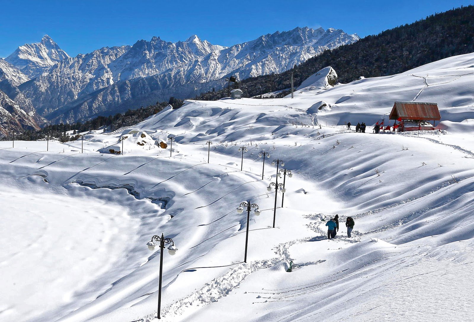
| Winter | December–February | Snow-covered trails, frosty forests, adventurous winter trek |
Note: The best time to visit Nag Tibba is from October to March for clear weather or April to June for milder conditions. Autumn (September–November) and spring (March–May) offer the best conditions for hassle-free trekking, with dry trails, clear skies, and mild temperatures of 11–21°C daytime highs. Winter (December–February) adds snow magic for enthusiasts but requires gear for sub-zero nights down to -8°C. Avoid the monsoon season entirely for zero hassle.
Temperature
| Season | Daytime Temperature | Nighttime Temperature |
|---|---|---|
| Summer (March–June) | 10°C to 25°C | 5°C to 10°C |
| Monsoon (July–September) | 15°C to 20°C | 10°C to 15°C |
| Autumn (Sept–Nov) | 8°C to 18°C | 2°C to 8°C |
| Winter (Dec–Feb) | 5°C to 12°C | -3°C to 3°C |
Nearby Places
| Destination | Distance from Nag Tibba | Highlights |
|---|---|---|
| Pantwari Village | ~12 km (base) | Trek base, homestays, local shops |
| Kempty Falls | ~57 km | Popular waterfall near Mussoorie |
| Kanatal | ~60 km | Hill station, coniferous trees, weekend getaway |
| Lal Tibba | ~65 km | Highest point in Mussoorie, mountain views |
| Mussoorie | ~57 km | Queen of Hills, Mall Road, Gun Hill |
| Dhanaulti | ~92 km | Tranquil hill station, eco-parks |
| Nainbagh | ~12 km | Scenic hilly town, confluence of three districts |
| Thatyur | ~30 km | Village near the Aunter route |
| Devalsari | ~55 km | Alternative trek route, rich birdlife |
| New Tehri | ~148 km | Tehri Lake, dam, water sports |
Distance from Major Cities
| City | Distance (Approx.) | Travel Time |
|---|---|---|
| Delhi | ~350 km | 7–8 hours |
| Dehradun | ~85–100 km | 2–3 hours |
| Mussoorie | ~57 km | 1.5–2 hours |
| Haridwar | ~120 km | 3–4 hours |
| Rishikesh | ~140 km | 4–5 hours |
Frequently Asked Questions (FAQs)
General Questions
Q1: What is Nag Tibba?
A: Nag Tibba, meaning “Serpent’s Peak,” is the highest peak in the Lesser Himalayan region of the Garhwal Division in Uttarakhand, standing at 3,022 metres (9,915 feet).
Q2: Where is Nag Tibba located?
A: Nag Tibba is located in the Jaunpur Range of the Tehri Garhwal district, Uttarakhand, about 57 km from Mussoorie and 85–100 km from Dehradun.
Q3: What is the elevation of Nag Tibba?
A: Nag Tibba is situated at an elevation of 3,022 metres (9,915 feet) above sea level.
Q4: What is Nag Tibba famous for?
A: Nag Tibba is famous for its Nag Devta Temple, 360-degree Himalayan views, and being one of the most accessible weekend treks in Uttarakhand.
Q5: What is the best time to visit Nag Tibba?
A: The best time is October–March for clear weather and April–June for mild conditions.
Q6: What is the nearest airport to Nag Tibba?
A: The nearest airport is Jolly Grant Airport in Dehradun, approximately 96 km away.
Q7: What is the nearest railway station to Nag Tibba?
A: The nearest railway station is Dehradun Railway Station, approximately 73 km away.
Q8: How far is Nag Tibba from Delhi?
A: Nag Tibba is approximately 350 km from Delhi, about a 7–8 hour drive.
Q9: What is the vehicle registration code for Nag Tibba?
A: The vehicle registration code is UK-09 (Tehri Garhwal district).
Q10: What is the trek difficulty level of Nag Tibba?
A: The Nag Tibba trek is rated easy to moderate, suitable for beginners and first-time trekkers.
Q11: What is the trek duration for Nag Tibba?
A: The Nag Tibba trek is typically a 2-day / 1-night trek from Pantwari.
Q12: What is the trek distance for Nag Tibba?
A: The trek distance is approximately 10 km one way (Pantwari to summit) and 18–20 km round trip.
Q13: What is the starting point of the Nag Tibba trek?
A: The trek starts from Pantwari Village, about 85–100 km from Dehradun.
Q14: What is the Nag Devta Temple?
A: The Nag Devta Temple is a small shrine at the summit of Nag Tibba, dedicated to the serpent god, where locals offer prayers for the protection of their cattle.
Q15: What wildlife can be found near Nag Tibba?
A: Nag Tibba is home to Himalayan leopards, Himalayan black bears, deer, langurs, and various bird species, including the Himalayan woodpecker.
Q16: How do I reach Nag Tibba from Dehradun?
A: Nag Tibba is about 85–100 km from Dehradun, reachable by road via Mussoorie and Nainbagh. Taxis and shared cabs are readily available.
Q17: What is the mythological significance of Nag Tibba?
A: Nag Tibba is believed to be the abode of Nag Devta (the Serpent God), and the summit temple is a sacred site for local Garhwali communities.
Q18: What is the local language of Nag Tibba?
A: The official language is Hindi, and the regional language is Garhwali.
Q19: Is Nag Tibba a good destination for beginners?
A: Yes, Nag Tibba is a perfect trek for beginners and can be done easily by first-time trekkers.
Q20: What are the nearby places to visit from Nag Tibba?
A: Nearby places include Kempty Falls, Kanatal, Lal Tibba, Mussoorie, Dhanaulti, and Nainbagh.
Q21: What is the Nag Tibba Range?
A: The Nag Tibba Range is one of the three principal ranges of the Lesser Himalayas, along with the Dhauladhar and Pir Panjal ranges.
Q22: What food is available at Nag Tibba?
A: Basic food is available at Pantwari village and the campsite. Trekkers are advised to carry their own snacks and water.
Q23: Is photography allowed at Nag Tibba?
A: Yes, photography is allowed and is one of the main activities. The sunrise and sunset views from the summit are particularly spectacular.
Q24: Can I camp at Nag Tibba?
A: Yes, camping is allowed at designated sites like Khatian Campsite. It is recommended to camp with a guide or organised group.
Q25: What is the distance from Mussoorie to Nag Tibba?
A: The distance from Mussoorie to Nag Tibba is approximately 57 km.
Q26: What is the distance from Rishikesh to Nag Tibba?
A: The distance from Rishikesh to Nag Tibba is approximately 140 km.
Q27: What is the significance of the Nag Tibba summit?
A: The summit offers a 360-degree panoramic view of Himalayan peaks including Bandarpoonch, Swargarohini, Gangotri, and Srikantha.
Q28: What is the Devalsari route?
A: The Devalsari route is an alternative trekking route to Nag Tibba, starting from Devalsari village, offering a more secluded and forest-rich experience.
Q29: What should I carry for the Nag Tibba trek?
A: Carry layered clothing, sturdy trekking shoes, rain protection, a headlamp, a first-aid kit, and 3 litres of water.
Q30: What is the best way to explore Nag Tibba?
A: The best way is by trekking — the mountain is best explored on foot, with trails leading through forests and meadows to the summit.
Essential Tips for Visitors
- Best Time: Plan your trek between October–March for clear weather or April–June for mild conditions
- Footwear: Wear sturdy trekking shoes with good grip for the rocky and uneven terrain
- Clothing: Carry layered clothing — warm jacket for mornings/evenings, windproof outer layer, and rain protection in monsoon
- Monsoon Caution: Avoid trekking during July–August due to slippery trails and landslide risks
- Trek Preparation: The trek is easy to moderate but requires basic fitness; beginners should train with 5 km hikes
- Permits: Indian nationals do not need special permits for the trek, but carry a valid photo ID
- Local Cuisine: Try local Garhwali dishes in Pantwari; carry your own food for the trek
- Hydration: Carry at least 3 litres of water, especially during summer months
- Accommodation: Accommodation is available in Pantwari (homestays and guesthouses)
- Respect Local Culture: Nag Tibba is a sacred site; maintain the sanctity of the temple and natural surroundings
- Leave No Trace: Respect the fragile Himalayan ecosystem — carry back all waste
- Inform Family: Let someone know your itinerary before trekking, as mobile connectivity may be weak
- Weather Updates: Check weather forecasts before travelling, especially during monsoon and winter
- Start Early: Start early to beat crowds and midday heat, especially on the summit day
- Guided Treks: Opt for guided packages for permits, meals, and transport from Dehradun, ensuring safety on steeper summit inclines
Plan Your Nag Tibba Adventure with Discover Uttarakhand
At Discover Uttarakhand, we’ve been organising unforgettable Himalayan journeys since 1997. As a trusted local operator with deep knowledge of the Garhwal region, we offer:
✅ Customised Nag Tibba trek packages
✅ Combined itineraries with Mussoorie, Kanatal, and Dhanaulti
✅ Experienced local guides and trek leaders
✅ Comfortable transport with experienced hill drivers
✅ All necessary permits and arrangements
✅ Quality camping equipment and nutritious meals
✅ 24/7 customer support throughout your journey
Recommended Nag Tibba Packages
| Package | Duration | Starting Point | Highlights |
|---|---|---|---|
| Nag Tibba Weekend Trek | 2 Days / 1 Night | Dehradun | Nag Tibba Summit, Nag Devta Temple, Camping |
| Nag Tibba Winter Snow Trek | 3 Days / 2 Nights | Delhi | Snow Trek, Summit Views, Campfire |
| Nag Tibba & Mussoorie Explorer | 4 Days / 3 Nights | Dehradun | Nag Tibba, Kempty Falls, Mussoorie, Lal Tibba |
| Nag Tibba Complete Exploration | 5 Days / 4 Nights | Delhi | Nag Tibba, Mussoorie, Kanatal, Dhanaulti, Dehradun |
📞 Call / WhatsApp: +91-9997187178, 9760222178, 8171977178
📍 Visit Our Office: Himalayan Colony, opposite DSVV, Haripur Kalan, Haridwar, Motichur Range, Uttarakhand 249411
🌐 Website: www.discover-uttarakhand.com
📧 Email: discoveruttarakhand.mail@gmail.com
Plan your journey to Nag Tibba with proper preparation and respect for this sacred land where serpent legends come alive. Experience the divine presence of the Himalayas in one of India’s most accessible and naturally breathtaking destinations.
Discover Uttarakhand – Your Local Partner for Unforgettable Himalayan Journeys Since 1997 🏔️