Introduction: The Mountain That Writes ‘ॐ’ in Snow
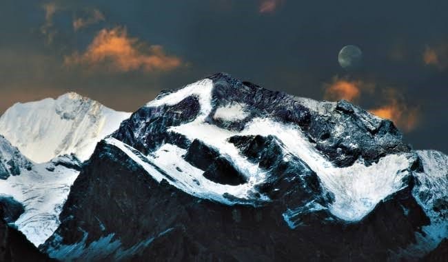
High in the remote Kumaon Himalayas of Uttarakhand’s Pithoragarh district, near the trijunction of India, Nepal, and Tibet, lies a mountain that seems to have been touched by the divine. Om Parvat is a sacred Himalayan peak where snow naturally settles into the shape of the sacred ‘ॐ’ (Om) symbol on its dark rock face—a phenomenon that has drawn pilgrims, seekers, and curious travellers for generations.
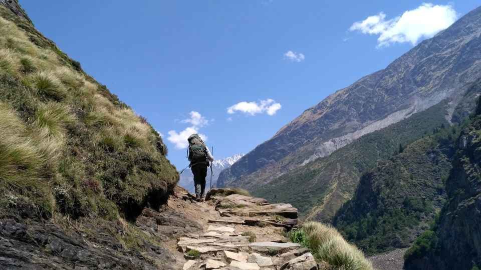
For many, the first clear sight of that symbol is a deeply moving experience: prayer flags fluttering in the thin, cold air, a profound stillness that makes you lower your voice without thinking, and a quiet personal moment that feels bigger than any photograph could capture. Om Parvat is not a casual hill-station stop—it is a remote high-altitude mountain darshan reached through a multi-day journey via Dharchula, Gunji, and Nabhidhang.
The mountain holds immense significance in Hindu mythology. ‘Om’ (ॐ) is the primal sound of the universe, the first vibration from which all of creation emerged. Seeing this sacred symbol naturally formed on a mountain is considered a divine sign and a rare blessing. For centuries, local communities and travelling sadhus have spoken of a mountain face where snow settled into the form of ‘ॐ,’ turning the peak into a darshan mountain—not a summit to conquer but a presence to witness.
Whether you are a devout pilgrim seeking to witness this natural wonder, a trekker looking for a remote Himalayan adventure, or a nature lover drawn to raw mountain beauty, Om Parvat offers an experience that is both spiritually transformative and visually breathtaking.
Quick Facts – Om Parvat
History and Mythology: The Sacred Symbol in the Snow
The Meaning of Om Parvat
The name “Om Parvat” derives from the Sanskrit word ‘Om’ (ॐ), which is composed of three sounds: A, U, and M. These sounds represent the three states of consciousness—waking, dreaming, and deep sleep—as well as the three realms of existence: earth, atmosphere, and heaven. The fourth state, beyond these three, is silence or pure consciousness, symbolised by the dot above the crescent in the Om symbol. Om Parvat is thus considered a representation of the ultimate reality that transcends the phenomenal world.
Association with Lord Shiva
Om Parvat is considered sacred by Hindus and is believed to be associated with Lord Shiva, the supreme deity of Hinduism. Shiva is the destroyer and transformer of evil and ignorance, and the source of all knowledge and wisdom. He is also the patron of yoga and meditation—practices that aim to achieve union with the divine. Om Parvat is said to be a manifestation of Shiva’s power and grace, and a place where one can experience his presence and blessings.
The Natural ‘Om’ Formation
The mountain is famous for a distinct ‘ॐ’ shape formed by snow deposition on its dark rock face. The symbol is not always sharp in every season—it depends on snowfall and melt patterns—but when the weather opens up, the view can be strikingly clear. The best time to see the Om symbol clearly is during the September–October period, when fresh snow settles on the rock face.
Connection to the Kailash Manasarovar Yatra
Om Parvat has been part of Kumaon’s sacred border landscape for generations, woven into the older pilgrimage culture of the Kali valley and the trans-Himalayan trade routes that once linked these villages with Tibet. The mountain can be viewed on the route to the Kailash Manasarovar Yatra from the last camp (Nabhidhang) en route to Lipulekh Pass. It has always been considered a sacred mountain for Hindus all over the world.
The First Ascent
Despite its sacred status, Om Parvat has seen climbing attempts. The first recorded attempt was by an Indo-British team including Martin Moran, T. Rankin, M. Singh, S. Ward, A. Williams, and R. Ausden. The climbers promised not to ascend the final 10 meters out of respect for the peak’s holy status. However, they were stopped around 200 meters short of the summit by very loose snow and rock conditions. The first ascent of Adi Kailash (sometimes confused with Om Parvat) came on October 8, 2004.
Geography and Location
Geographic Coordinates
Location
Om Parvat is situated in the Pithoragarh district of Uttarakhand, in the Kumaon region of the Himalayas. The mountain lies on the border between India and Nepal, with the “Om” symbol facing the Indian side. It is located near Nabhidhang camp on the Mount Kailash-Lake Manasarovar yatra route.
The Surrounding Landscape
Near Om Parvat lie Parvati Lake and Jonglingkong Lake, both considered sacred by Hindus—Jonglingkong Lake is revered as Lake Manasarovar. The mountain sits in the Vyas Valley of the Pithoragarh district, named after the sage Ved Vyas, who is believed to have meditated in this region.
Adi Kailash vs. Om Parvat
It is important to note that Adi Kailash (Chhota Kailash) and Om Parvat are different mountains located in different directions :
The Sacred ‘Om’ Symbol: Nature’s Divine Signature
What Makes Om Parvat Special
The most remarkable feature of Om Parvat is the natural formation of the sacred ‘Om’ (ॐ) symbol on its dark rock face, created by the deposition of snow. This phenomenon is considered a divine sign and holds immense spiritual significance for devotees.
When Is the ‘Om’ Most Visible?
What to Expect When You See It
When the clouds break and the ‘Om’ comes into view, people naturally fall quiet. Some fold their hands in prayer, some simply stare in awe—either way, it’s a moment that feels bigger than a simple photograph. The air here is thin and cold, even on sunny days. Wind whistles through rocks and prayer flags, and you often smell a mix of dry alpine earth and pine carried from lower ridges.
Photography Tips
- The best time to photograph is early morning when the light is steady on the mountain face
- Carry a telephoto lens for close-up shots of the Om symbol
- Be patient—clouds can cover the symbol for hours and then clear in minutes
- The symbol is best viewed from the Indian side (Nabhidhang)
How to Reach Om Parvat
By Air
Nearest Airport: Pantnagar Airport (approximately 306 km from Dharchula)
- Airlines: Regular flights from Delhi to Pantnagar (approx. 1 hour)
- Travel Time: 8–9 hours by taxi from the airport to Dharchula
- Onward Travel: From the airport, hire a taxi to Kathgodam or directly to Dharchula
By Train
Nearest Railway Station: Kathgodam (approximately 272 km from Dharchula)
| Train Name | From Delhi | Departure | Arrival (Kathgodam) | Duration |
|---|---|---|---|---|
| Ranikhet Express | Delhi | 10:05 PM | 5:05 AM | 7 hours |
| Shatabdi Express | Delhi | 6:00 AM | 11:40 AM | 5h 40m |
From Kathgodam station, taxis are available for the 9–10 hour drive to Dharchula.
By Road
Om Parvat is reached through the Dharchula – Gunji – Nabhidhang high-border corridor. This is the same zone as the Adi Kailash Yatra, and travel is controlled through permits due to proximity to the border.
Route Overview:
Total Distance from Delhi: Approximately 760 km
Distances from Major Cities
| City | Distance (km) |
|---|---|
| Delhi | ~760 |
| Kathgodam | 272 |
| Pithoragarh | ~100 |
| Dharchula | 0 (permit town) |
| Gunji | ~70 |
| Nabhidhang (Om Parvat) | ~21 from Gunji |
Inner Line Permit (ILP) – Mandatory Documentation
Om Parvat is located in a restricted border area near the India–China–Nepal trijunction. Therefore, an Inner Line Permit (ILP) is mandatory for all Indian citizens undertaking the yatra.
Where to Obtain the Permit
- Issuing Authority: SDM Office, Dharchula
- Timing: During the yatra season (May–October)
- Processing Time: Usually a few days; tour operators often handle this in advance
Documents Required
- ✅ Valid government-issued photo ID (Aadhaar Card, Passport, Voter ID)
- ✅ 2–3 passport-size photographs
- ✅ Medical fitness certificate from a registered doctor
- ✅ Police verification form (or photocopy of passport)
Important Notes
- Foreign nationals are not permitted on the Om Parvat/Adi Kailash Yatra at present
- Tour operators typically handle the entire permit process for their clients
- The permit is checked at multiple checkpoints along the route
- Ensure the permit covers your entire stay in the region
Best Time to Visit Om Parvat
Season-by-Season Guide
Best Time of Day for Darshan
- Early morning: Clearer skies, steady light on the mountain face, calmer wind
- Late morning: Still good, but clouds can start forming quickly at this altitude
- Afternoon: Not recommended due to afternoon fog and cloud cover
Critical Weather Note
One of the most surprising aspects of Om Parvat’s climate is the extreme temperature drop after sunset. A sunny afternoon at 14°C can become -3°C within hours. Pilgrims should never judge the weather only by daytime comfort.
The Om Parvat Yatra: What to Expect
Is It a Trek or a Drive?
Om Parvat is primarily a drive-based yatra with short walks near darshan points. However, the roads are rough, narrow mountain tracks that require 4×4 vehicles and experienced local drivers.
Typical Itinerary (from Dharchula)
Experience at the Darshan Point
The air here is thin and cold, even on sunny days. When the clouds break and the ‘Om’ comes into view, people naturally fall quiet. Some fold their hands, some just stare—either way, it’s a moment that feels bigger than a photo.
Facilities at the Darshan Point
- Shops/Eateries: Very limited. Carry snacks and water from your previous stop
- Toilets: Basic facilities available
- Shelter: Limited; be prepared for open-air viewing
Crowd & Atmosphere
Because Om Parvat is reached only via permits and long travel, the crowd is usually limited but deeply motivated. Expect small groups of pilgrims, a few trekkers, and locals supporting the yatra. It feels more like a shared pilgrimage than a tourist queue.
Things That Surprise First-Time Visitors
First-time visitors to Om Parvat often encounter unexpected challenges :
- The cold wind hits suddenly, even in sunshine – Wind makes it feel much colder than the thermometer suggests.
- Visibility changes fast – Patience often rewards you with a clear view after waiting.
- Altitude fatigue can show up quietly – Slow down and sip water frequently.
- Nighttime is freezing – Even in summer, temperatures drop well below freezing after sunset .
- No mobile network – You’ll be completely disconnected from the outside world.
Nearby Places to Visit
Accommodation Options
Booking Tips
- Most tour operators include accommodation in their packages
- For independent travel, book homestays in Gunji through local contacts
- The yatra has limited accommodation capacity; early booking is essential
Sample Itinerary (8 Days / 7 Nights from Kathgodam)
| Day | Route | Distance | Activities | Overnight |
|---|---|---|---|---|
| 1 | Kathgodam → Pithoragarh | ~196 km | Drive via Kainchi Dham, Golu Devta, Jageshwar | Pithoragarh |
| 2 | Pithoragarh → Dharchula | ~100 km | Scenic drive, Kali River views, permit processing | Dharchula |
| 3 | Dharchula → Gunji/Nabi | ~70 km | 4×4 drive, acclimatization | Gunji/Nabi |
| 4 | Gunji → Jolingkong → Adi Kailash → Gunji | ~68 km | Adi Kailash darshan, Parvati Sarovar | Gunji |
| 5 | Gunji → Nabhidhang → Om Parvat → Gunji | ~42 km | Om Parvat darshan, Kalapani Temple | Gunji |
| 6 | Gunji → Dharchula | ~70 km | Return drive | Dharchula |
| 7 | Dharchula → Chaukori | ~166 km | Scenic drive, tea gardens | Chaukori |
| 8 | Chaukori → Kathgodam | ~210 km | Departure | – |
This itinerary can be shortened to focus specifically on Om Parvat without Adi Kailash, but most pilgrims combine both due to overlapping routes and permits.
Essential Packing List
Clothing
- Thermal innerwear (top and bottom)
- Fleece jacket and heavy woollen sweater
- Down jacket or thick winter coat
- Waterproof outer shell/windproof jacket
- Woollen gloves, muffler, and woollen cap
- Heavy woollen socks (3–4 pairs)
- Sturdy, broken-in trekking shoes with good grip
- Comfortable slippers for evenings
Accessories and Gear
- Sunglasses with UV protection
- Sunscreen and lip balm (high altitude sun is intense)
- Trekking pole for stability
- Headlamp or torch with extra batteries
- Power bank for charging devices
- Reusable water bottle (insulated recommended)
Health and Hygiene
- Personal medications with a prescription
- First-aid kit with bandages, antiseptics, and pain relievers
- Altitude sickness medication (consult doctor)
- Basic toiletries, wet wipes, and hand sanitiser
- Moisturiser (high altitude causes dry skin)
Documents
- Valid ID proof (Aadhaar Card mandatory)
- Medical fitness certificate
- Passport-size photos (4–5 copies)
- Inner Line Permit (arranged by operator)
Food and Snacks
- Energy bars, dry fruits, nuts
- Electrolyte sachets
- Glucose for quick energy
- Chocolate for instant energy
Travel Tips and Important Information
Before You Go
- Medical Check-up: Consult your doctor before the yatra, especially if you have heart or respiratory conditions
- Physical Preparation: Regular walking, light jogging, or yoga for 4–6 weeks before the yatra is recommended
- Advance Booking: Essential for May–June and September–October
- Carry Cash: ATMs are extremely limited beyond Dharchula
- Inform Family: Mobile networks are limited; inform family of your itinerary
During the Yatra
- Acclimatise Properly: Take rest at Dharchula and Gunji before proceeding higher
- Dress in Layers: Temperatures swing dramatically between day and night
- Stay Hydrated: Drink plenty of water to prevent altitude sickness
- Eat Light: Avoid heavy, oily meals; stick to simple vegetarian food
- Respect Local Customs: Om Parvat is a sacred site; maintain respectful silence
- Trust Local Drivers: Roads are rough and require experienced 4×4 drivers
Health and Safety
- Altitude Sickness: Symptoms include headache, nausea, and dizziness. If symptoms worsen, descend immediately
- Oxygen Support: Tour operators carry portable oxygen cylinders for emergencies
- Medical Facilities: Basic facilities are available in Dharchula and Gunji; advanced hospitals are far away
- Emergency Numbers: Keep local contacts and tour operator numbers handy
Road Safety
- Expect rough, narrow mountain roads—trust only local 4×4 drivers
- Monsoon and post-monsoon landslides are real; keep buffer days
- Carry rain/wind protection even if the morning looks clear
Who Should Avoid This Yatra
- Those with serious heart or lung conditions
- Pregnant women
- People with uncontrolled blood pressure or diabetes
- Anyone recently recovering from surgery or severe illness
Frequently Asked Questions (FAQs)
Q1: What is Om Parvat famous for?
A: Om Parvat is famous for the natural formation of the sacred ‘ॐ’ (Om) symbol on its dark rock face, created by snow deposition. It is considered a divine sign and holds immense spiritual significance for Hindus.
Q2: What is the best time to visit Om Parvat?
A: The best time to visit is May to June (summer) for pleasant weather and September to October (post-monsoon) for crystal-clear mountain views and the clearest Om symbol visibility.
Q3: How far is Om Parvat from Delhi?
A: The total distance from Delhi is approximately 760 km, with a travel time of 8–9 days recommended for the complete yatra, including permits and acclimatisation.
Q4: Is a permit required for Om Parvat Yatra?
A: Yes, an Inner Line Permit (ILP) is mandatory as the region is near the India–China–Nepal border. It is issued at the SDM Office in Dharchula.
Q5: What is the altitude of Om Parvat?
A: The mountain stands at approximately 5,590–6,191 meters (18,340–20,312 feet). The darshan point at Nabhidhang is above 4,200 meters.
Q6: Is Om Parvat a trek or a drive?
A: It is primarily a drive-based yatra with short walks near darshan points. The exact walking distance depends on the road conditions for that season.
Q7: Can I visit Om Parvat without doing Adi Kailash?
A: Some itineraries focus only on Om Parvat, but most people combine both because the route and permits overlap.
Q8: Will I always see the ‘Om’ clearly?
A: Not guaranteed. The symbol depends on snowfall and cloud cover. Clear mornings in May–June and September–October give the best chance.
Q9: Is Om Parvat suitable for senior citizens?
A: If they are medically fit for high altitude and travel slowly with proper acclimatisation, yes. Always consult a doctor if your health is sensitive.
Q10: Is there a mobile network at Om Parvat?
A: Mobile connectivity is extremely limited beyond Dharchula. BSNL works in some pockets. Tour operators carry satellite communication for emergencies.
Q11: Are there shops or eateries at the darshan point?
A: Facilities are very limited. Carry snacks and water from your previous stop.
Q12: What is the difference between Adi Kailash and Om Parvat?
A: Adi Kailash is a pyramid-shaped peak believed to be Lord Shiva’s abode, with Parvati Sarovar at its base. Om Parvat is a separate mountain where snow naturally forms the ‘ॐ’ symbol. They are in different directions and are often visited together.
Q13: Is photography allowed at Om Parvat?
A: Yes, at general points. Always respect any local or administrative instructions in sensitive border areas.
Q14: What is the temperature at Om Parvat?
A: Daytime temperatures range from 5°C to 18°C in summer, dropping to -2°C to 5°C at night. In autumn, nights can be -5 °C to 2°C.
Q15: How cold does it get at night?
A: Even in summer, nights at Gunji and Nabhidhang can drop below freezing. Wind makes it feel much colder than the thermometer suggests.
Plan Your Om Parvat Yatra with Discover Uttarakhand
At Discover Uttarakhand, we’ve been organising sacred Himalayan journeys across Devbhoomi since 1997. As a trusted local operator with deep knowledge of the Om Parvat and Adi Kailash region, we offer:
- ✅ Customised Om Parvat Yatra packages (7 to 12 days)
- ✅ Combined Adi Kailash & Om Parvat itineraries
- ✅ Complete permit assistance (Inner Line Permit processing)
- ✅ Experienced local drivers with 4×4 vehicles for mountain terrain
- ✅ Comfortable transport from Kathgodam to Om Parvat
- ✅ Verified accommodations, including homestays in Gunji and tented camps at Nabhidhang
- ✅ Medical support with portable oxygen cylinders
- ✅ 24/7 customer support throughout your journey
Recommended Om Parvat Packages
| Package | Duration | Starting Point | Highlights |
|---|---|---|---|
| Om Parvat Darshan Special | 7 Days / 6 Nights | Kathgodam | Focus on Om Parvat, Gunji, Nabhidhang |
| Adi Kailash & Om Parvat Yatra | 9 Days / 8 Nights | Kathgodam | Both sacred peaks, Parvati Sarovar, Nabhidhang |
| Kumaon Pilgrimage | 11 Days / 10 Nights | Delhi | Om Parvat + Adi Kailash + Jageshwar + Chaukori |
Book your Om Parvat Yatra today and witness the divine ‘Om’ written in the snow.
📞 Call / WhatsApp: +91-9997187178, 9760222178, 8171977178
📍 Visit Our Office: Himalayan Colony, opposite DSVV, Haripur Kalan, Haridwar, Motichur Range, Uttarakhand 249411
🌐 Website: www.discover-uttarakhand.com
📧 Email: info@discover-uttarakhand.com
Om Namah Shivaya! Jai Om Parvat! 🙏🏔️
Discover Uttarakhand – Your Local Partner for Sacred Himalayan Journeys Since 1997