
Overview: The Mini Kashmir of Kumaon
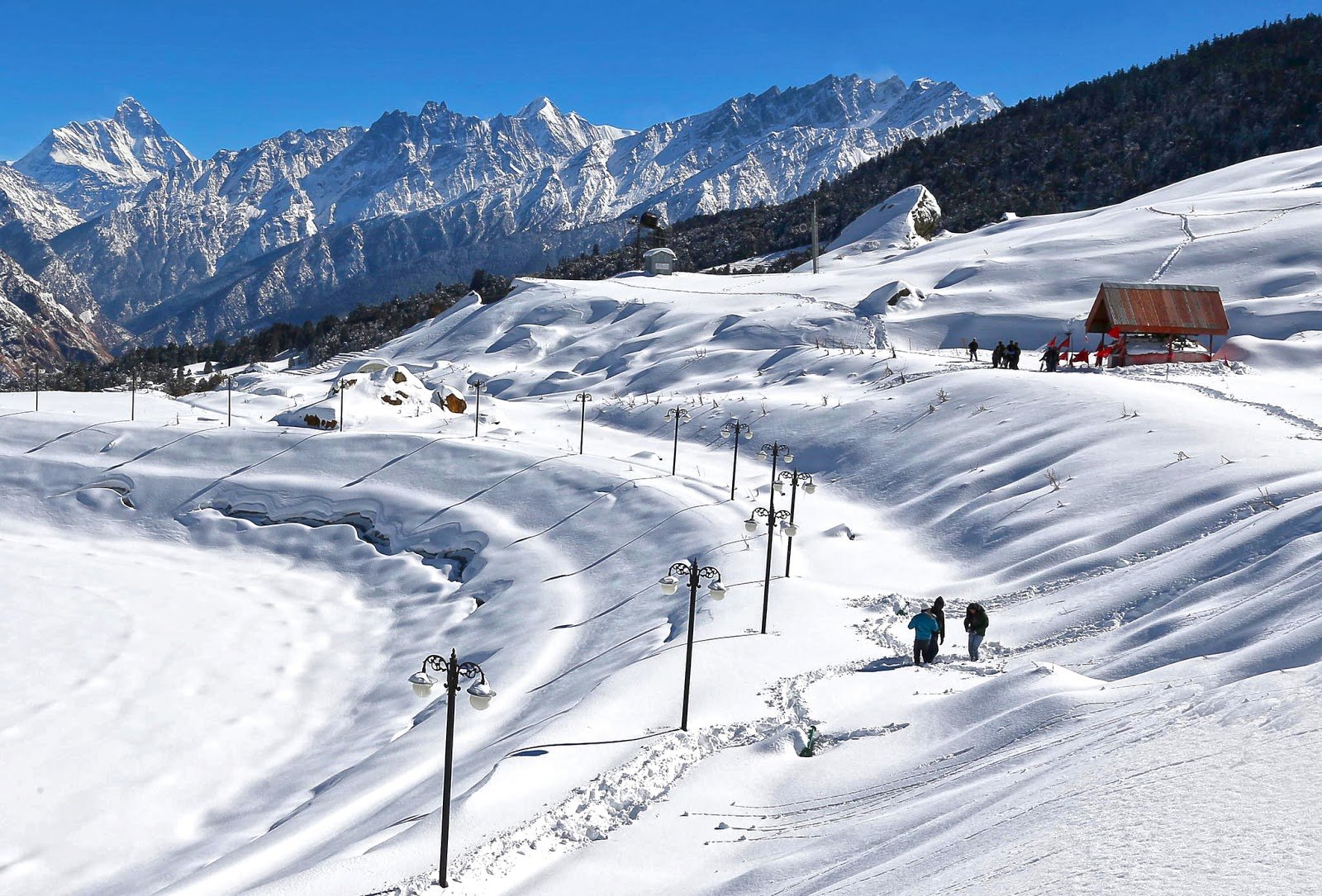
Tucked away in the easternmost corner of Uttarakhand, Pithoragarh is a breathtaking hill station that remains blissfully untouched by the overwhelming crowds that flock to more commercialised destinations. Often referred to as the “Mini Kashmir of Uttarakhand” [7†L2][9†L2], this enchanting town is nestled at an elevation of approximately 1,635 to 1,851 metres (5,364 to 6,073 feet) [8†L7][0†L27] in the heart of the Soar Valley, which bears a striking resemblance to the Kashmir Valley on a smaller scale [8†L15-L16].
Surrounded by four prominent hills — Chandak, Dhwaj, Thal Kedar, and Kumdar [7†L8-L9] — Pithoragarh is a land of unparalleled natural beauty. The town is bordered by Tibet to the north and Nepal to the east [7†L7-L8], making it a region of immense strategic and cultural significance. It serves as the gateway to the Himalayas from the north [8†L17], with pilgrims and trekkers passing through on their way to Kailash Mansarovar, Om Parvat, and Mount Kailash [8†L18][9†L9-L10].
Whether you are a history enthusiast exploring ancient forts, a pilgrim seeking spiritual solace at sacred temples, a trekker embarking on high-altitude adventures, or simply a traveller yearning for peace amidst snow-capped peaks and alpine meadows, Pithoragarh promises an experience that stays with you forever.
Key Information at a Glance
| Aspect | Details |
|---|---|
| Location | Easternmost district of Uttarakhand, Kumaon region |
| Also Known As | Mini Kashmir of Uttarakhand, Little Kashmir |
| Elevation | 1,635–1,851 m (5,364–6,073 ft) |
| District Formation | 1 February 1960 |
| Area | 7,100 sq km (approx.) |
| State | Uttarakhand |
| Region | Kumaon |
| Borders | Tibet (north), Nepal (east) |
| Distance from Delhi | 455–513 km (by road) |
| Nearest Airport | Naini Saini Airport (5 km), Pantnagar Airport (241 km) |
| Nearest Railway Station | Tanakpur (138 km), Kathgodam (212 km) |
| Best Time to Visit | April–June & September–November |
| Famous For | Panchachuli views, Kailash Mansarovar route, ancient temples, trekking |
| Languages | Hindi, Kumaoni, English |
| PIN Code | 262501 |
History of Pithoragarh
Ancient Origins and the Puranas
The lineage of Pithoragarh can be traced back to the age of the Puranas, when it flourished under various names, though no documents from that era have been recovered [8†L28-L29]. What is known is that Pithoragarh served as an important stopover on the route to Kailash Parbat [8†L30-L31]. Ancient religious texts such as the Rig Veda and Skanda Purana mention the various tribes that inhabited the area [8†L31-L32].
The Katyuri Kingdom (7th–11th Century)
In the past, Pithoragarh was part of Sorat, one of the eight forts in the Katyuri Kingdom, which held dominion over the whole of Kumaon from the 7th to the 11th century [9†L20-L22]. The Katyuris were promoters of the region’s farming, trading, and temple-building, leaving behind an amazing cultural legacy [9†L22-L24].
The Chand Dynasty (14th–16th Century)
Pithoragarh was under the rule of the Pal dynasty during the 14th and 15th centuries but was later conquered by the Chand dynasty in the 16th century [7†L26-L27][0†L6-L8]. As the citadel of the Chand dynasty, the town is dotted with several temples and ruined forts belonging to that era [7†L28-L29]. Once a major centre of power during the Chand kings’ regime in Kumaon, Pithoragarh boasts many spiritual sites [13†L13-L15].
The Gorkha Era and Pithoragarh Fort (1789)
In 1789, the Gorkhas established their control over the region [7†L29-L30]. They built a huge fort on the outskirts of the main town, known as Pithoragarh Fort [7†L30-L31]. The fort was constructed by King Bharti Chand in 1790 and became the emblem of the ruler’s power and administration [9†L25-L26].
The British Colonial Era
Subsequently, the region came under British authority, which developed it as an army cantonment town. A church and a mission school were also established during that period [7†L33-L35].
The Birth of a District (1960)
Pithoragarh came into existence as a separate district on 1 February 1960, before which it was part of the Almora district [7†L11-L12][0†L28-L29].
Geography of Pithoragarh
Location and Topography
Pithoragarh is the easternmost hill district of Uttarakhand and is part of the Kumaon region [7†L2-L5]. The town is situated in a small valley in the centre of four hills — Chandak, Dhwaj, Thal Kedar, and Kumdar [7†L8-L9].
| Feature | Details |
|---|---|
| Altitude | 1,635–1,851 m (5,364–6,073 ft) |
| Region | Kumaon |
| Valley | Soar Valley (Miniature Kashmir) |
The Soar Valley
The town is located in the western part of the Soar Valley, which is also known as “Miniature Kashmir” [7†L6-L7]. The valley bears a resemblance to the Kashmir Valley on a small scale [8†L15-L16].
Himalayan Peaks and Glaciers
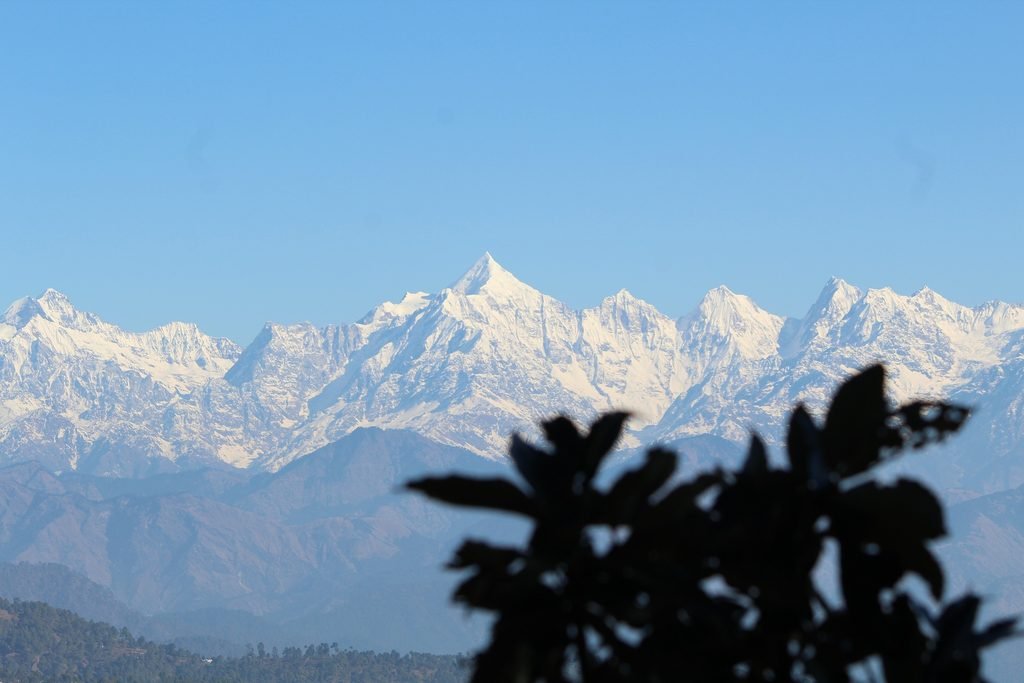
The northern part of the district is bejewelled by mighty snow-capped peaks, including Nanda Devi, Trishul, the Panchchuli group, Rajrambha, and several others [7†L15-L16]. The base of these mountains is decked with delightful views of glaciers, with the important ones being the Ralam Glacier, Milam Glacier, Namik Glacier, and Sunder Dhunga Glacier [7†L18-L19].
Rivers and Water Bodies
The town is separated from the desolate peaks of the Nepal hills by the Kali River [7†L10]. Pithoragarh is particularly famous for its numerous lakes, the two most renowned being Jolingkong (4,634 m) and Anchherital (3,659 m) [7†L45-L47].
Flora and Fauna of Pithoragarh
Flora — A Botanical Paradise
Mother Nature has munificently bestowed Pithoragarh with beguiling splendour and an affluent combination of topographic features [7†L19-L20]. The region is home to:
- Over 2,300 plant species [1†L28-L29]
- Dense conifer forests [8†L22-L23]
- Grassy alpine meadows [8†L23]
- A rich variety of flora and fauna in the Askot Wildlife Sanctuary basin due to its location at the junction of the Western and Central Himalayas [1†L13-L15]
Fauna — A Haven for Wildlife
Askot Wildlife Sanctuary, established in 1986, is the crown jewel of Pithoragarh’s wildlife heritage [1†L7-L8]. It is a vital Himalayan biodiversity hotspot, primarily dedicated to conserving the endangered Musk Deer [1†L8][1†L19-L20].
Key Species Found in the Region:
| Category | Species |
|---|---|
| Mammals | Himalayan Musk Deer, Snow Leopard, Himalayan Black Bear, Bharal (Blue Sheep), Himalayan Tahr, Goral, Serow, Red Fox, Leopard [1†L8-L9][1†L36-L37][10†L46-L47] |
| Birds | Himalayan Monal, Satyr Tragopan, Cheer Pheasant, Koklas Pheasant, Monal Pheasant, various raptors and pheasants [1†L29-L31][1†L37] |
The sanctuary supports 29 species of mammals and 225 bird species, including three critically endangered bird species [1†L28-L30]. A wide altitudinal variation in the sanctuary supports this exceptional diversity [1†L28].
Religious Beliefs and Sacred Sites
Pithoragarh is a deeply spiritual land, home to numerous ancient temples, cave shrines, and sacred sites that reflect the region’s rich cultural and religious heritage.
🛕 Major Temples
1. Kapileshwar Mahadev Temple
A serene and spiritually significant cave temple dedicated to Lord Shiva, located approximately 3 km from the main town of Pithoragarh [5†L6-L8][13†L22-L25]. One of the myths associated with the temple revolves around the sage Kapila, who meditated in the vicinity and imbued the surroundings with spiritual energy [10†L23-L25].
2. Patal Bhuvaneshwar
A limestone cave temple located 14 km from Gangolihat (91 km from Pithoragarh) [2†L21-L22][14†L16-L17]. It is traditionally believed to be the abode of thirty-three crore deities [2†L16-L17][14†L23-L24]. The main passageway opens into several small caves with stone carvings of many traditional gods and goddesses [14†L19-L22]. The temple is dedicated to Lord Shiva, Ganesha, Vishnu, and 33 Koti other deities [2†L23-L24]. The festival of Maha Shivaratri is celebrated here with great fervour [2†L24-L25].
3. Dhwaj Temple
Dedicated to Lord Shiva and Goddess Jayanti, this temple is located at an altitude of 2,100 metres and offers spectacular views of the Himalayas [9†L44-L45][13†L19-L21]. It is believed that the Pandavas visited the region during their exile and established the temple as a homage to Shiva [10†L41-L42].
4. Mostamanu Temple
One of the city’s most visited destinations, this temple is located near Pithoragarh Fort, about 6 km from the main town [14†L25-L26]. It is dedicated to God Mosta, considered the god of this region [14†L26-L27]. A local fair is organised in August–September [14†L30-L31].
5. Mahakali Temple, Gangolihat
Located 77 km from Pithoragarh in Gangolihat, this is a Shakti Peeth chosen by Adi Shankaracharya for the installation of Mahakali Shakti Peeth [14†L2-L4][14†L4-L5]. The goddess Kali is represented in her fierce form [14†L6-L7].
6. Kamaksha Temple
Located about 7 km north-east of Pithoragarh, near the army cantonment base, on the top of a hillock overlooking the surrounding mountain ranges [14†L35-L37].
7. Ulkadevi Temple
Situated on the Pithoragarh-Chandak motor road, this temple offers a remarkable view of the sprawling Soar Valley [14†L37-L41].
8. Jayanti Temple, Dhwaj
Located 18 km from Pithoragarh on the Didihat road, accessible via a 3 km steep climb. From the hilltop, the Panchachuli and Nanda Devi peaks can be clearly sighted [14†L41-L47].
9. Arjuneshwar Temple
Located 10 km west of Pithoragarh town on the top of a hill [14†L47].
10. Thal Kedar Temple
An ancient Shiva shrine located about 16–20 km from Pithoragarh, famous for its night celebrations during Shivratri and scenic trekking trails [5†L37-L38][9†L39-L41].
🏰 Pithoragarh Fort
Built by the Gorkhas in the 18th century, this fort’s strategic location provided a vantage point for monitoring and defending against potential invasions [10†L17-L18][10†L18-L19]. Seated on the crown of a hill, it is a bit difficult to climb but worth it for the pictorial sights of Kali Kumaon [7†L31-L33]. Sunrise and sunset are a particular treat to witness from the fort [10†L21-L22].
✨ Sacred Sites
- Nakuleshwar Temple [7†L40]
- Manu Temple — located just 2 km away and highly venerated by local inhabitants [7†L44-L45]
How to Reach Pithoragarh
By Air — Nearest Airports
| Airport | Distance | Details |
|---|---|---|
| Naini Saini Airport (Pithoragarh) | 5 km | Small airstrip with daily commercial flights |
| Pantnagar Airport | 241 km | Nearest major domestic airport |
| Jolly Grant Airport, Dehradun | — | Connected via 18-seater flights |
Latest Update (2026): Daily commercial flights from Pithoragarh finally took off on 30 January 2024 [12†L30-L31]. An 18-seater plane operates between Jolly Grant Airport in Dehradun and Naini Saini Airport in Pithoragarh on Monday, Tuesday, and Friday [12†L31-L32][12†L38]. Flight time is approximately 75 minutes, with fares ranging from ₹4,198 to ₹6,300 one way [12†L33-L37]. A daily helicopter service is also available from Haldwani [12†L22-L23].
By Train — Nearest Railway Stations
| Station | Distance | Details |
|---|---|---|
| Tanakpur Railway Station | 138 km | Nearest railhead; well-connected to Delhi |
| Kathgodam Railway Station | 212 km | Alternative station |
From Tanakpur: Taxis and buses are easily available from Tanakpur to Pithoragarh [12†L13-L16].
By Road
| Route | Distance | Travel Time |
|---|---|---|
| Delhi → Pithoragarh | 455–513 km | 10–11 hours |
| Nainital → Pithoragarh | 178 km | ~5–6 hours |
| Almora → Pithoragarh | ~90 km | ~3–4 hours |
Route from Delhi: Delhi → Moradabad → Bareilly → Pilibhit → Tanakpur → Champawat → Pithoragarh
Transport Options:
- Buses: Regular buses from ISBT Anand Vihar, New Delhi, to Pithoragarh [12†L6-L7]
- Private Taxi: Most convenient and flexible
- Self-Drive: Well-maintained roads via NH-125 [12†L12]
Distance from Major Cities
| City | Distance | Travel Time |
|---|---|---|
| Delhi | 455–513 km | 10–11 hours |
| Nainital | 178 km | 5–6 hours |
| Almora | ~90 km | 3–4 hours |
| Tanakpur | 138 km | 3–4 hours |
| Champawat | ~80 km | 2–3 hours |
| Badrinath | 329 km | 8–10 hours |
Weather and Best Time to Visit
Climate Overview
Pithoragarh experiences a pleasant mountain climate with comfortable summers and cold winters. About one-third of Pithoragarh is perpetually covered by snow [8†L23-L24].
Seasonal Breakdown
| Season | Months | Temperature | Conditions | Suitability |
|---|---|---|---|---|
| Spring | March–May | 10°C – 25°C | Pleasant, blooming rhododendrons | ⭐ Best |
| Summer | April–June | 12°C – 24°C | Clear skies, ideal for sightseeing | ⭐ Best |
| Monsoon | July–August | Variable | Heavy rainfall, landslides, slippery roads | ❌ Avoid |
| Autumn | September–October | 8°C – 18°C | Post-monsoon clarity, perfect for photography | ⭐ Best |
| Winter | November–February | 0°C – 22°C | Cold, snow in higher reaches | ⭐ Good |
Best Time to Visit
| Purpose | Best Months |
|---|---|
| Overall Best | April–June & September–November |
| Clear Panchachuli Views | October (post-monsoon) [4†L32-L34] |
| Trekking | April (12–24°C) [4†L28-L30] |
| Spring Blooms | March–April [4†L25] |
| Kailash Mansarovar Pilgrimage | May–June |
Why Visit in Summer (April–June)
- Clear skies with perfect 12–24°C temperatures for trekking and acclimatisation [4†L28-L29]
- Rhododendrons blooming [4†L30]
- All trails open
- The weather is pleasant enough for sightseeing [4†L17-L18]
Why Visit in Autumn (September–October)
- Post-monsoon perfection with 8–18°C temperatures [4†L34]
- Panchachuli range is crystal clear [4†L34-L35]
- Cleanest air of the year [4†L35]
- Best for photography [4†L33]
Why to Avoid Monsoon (July–August)
- Heavy rainfall leading to landslides and slippery roads [4†L19-L20]
- Advised to avoid travelling during this season [4†L20]
Packing Guide
| Category | Items |
|---|---|
| Clothing | Light cotton (summer), warm layers (winter), comfortable walking shoes |
| Essentials | Sunscreen, sunglasses, hat, power bank, camera |
| Documents | Valid ID proof |
| Seasonal | Raincoat (monsoon), heavy woollens (winter) |
Nearby Places to Visit
| Destination | Distance | Highlights |
|---|---|---|
| Chandak Hills | 8 km | Paragliding venue, panoramic views of Panchachuli peaks [9†L36-L38] |
| Kapileshwar Mahadev Temple | 3 km | Ancient cave temple dedicated to Lord Shiva [5†L6-L8] |
| Thal Kedar | 16–20 km | Ancient Shiva shrine, Shivratri celebrations [5†L37-L38][9†L39-L40] |
| Askot Wildlife Sanctuary | 54–60 km | Musk deer, snow leopards, Himalayan black bears [9†L41-L43] |
| Dhwaj Temple | 18 km | Shiva and Jayanti temple at 2,100 m [9†L44-L46] |
| Munsiyari | ~120 km | Gateway for Milam Glacier treks [5†L35-L36] |
| Gangolihat | 77 km | Mahakali Temple, folk culture [14†L2-L4] |
| Berinag | ~40 km | Tea gardens, Panchachuli views [5†L27-L31] |
| Chaukori | ~60 km | Tea gardens, Panchachuli views at 2,010 m [5†L16-L18] |
| Patal Bhuvaneshwar | 91 km | Underground cave temple, abode of 33 crore deities [14†L16-L17][14†L23-L24] |
Things to Do in Pithoragarh
1. Explore Pithoragarh Fort
Visit this historic 18th-century Gorkha fort and witness the commanding views of the surrounding landscape. Sunrise and sunset are a particular treat to witness from the fort [10†L21-L22].
2. Visit the Ancient Temples
Explore the numerous temples — Kapileshwar Mahadev, Dhwaj Temple, Mostamanu Temple, and the cave temple of Patal Bhuvaneshwar — each with its own unique history and spiritual energy.
3. Trek to Chandak Hills
Enjoy a trek to the Chandak Hills (8 km from Pithoragarh), which offers breathtaking landscape views of the Soar Valley [10†L27-L28]. The area is also a paragliding venue [9†L37-L38].
4. Visit Askot Wildlife Sanctuary
Drive to the Askot Musk Deer Sanctuary (54–60 km away) to spot endangered species like the musk deer, snow leopard, and Himalayan black bear [9†L41-L43][10†L40-L41].
5. Stargazing
Grab the opportunity to stargaze in the clear Himalayan skies [10†L38-L39].
6. Explore Local Culture
Experience the rich Kumaoni culture, including Aipan (Alpana), the popular art form of the Kumaon region involving the decoration of walls, papers, and cloth with geometric designs and figures of gods and goddesses [13†L11-L13].
7. Photography
Capture the stunning views of the Panchachuli peaks turning gold at sunrise and pink at sunset [5†L18-L19].
8. Shopping
Explore local markets for Kumaoni handicrafts, woollens, and local produce.
Accommodation Options
| Type | Features | Price Range |
|---|---|---|
| Hotels | Comfortable stays with modern amenities | ₹1,500 – ₹5,000 |
| Guesthouses | Budget-friendly, basic amenities | ₹800 – ₹1,800 |
| Homestays | Authentic local experience, home-cooked meals | ₹800 – ₹2,000 |
| Forest Rest Houses | Government-run, basic amenities | ₹500 – ₹1,500 |
Travel Tip: Pithoragarh is a small town with limited luxury options. It is advisable to book accommodation in advance, especially during the peak season (April–June and September–November).
Local Cuisine — A Taste of Kumaon
Must-Try Kumaoni Dishes
| Dish | Description |
|---|---|
| Bhatt Ki Churkani | Black soybean curry, a Kumaoni speciality |
| Chainsoo | Protein-rich black gram curry |
| Gahat Ka Shorba | Nutritious soup made from horse gram |
| Mandua Roti | Finger millet flatbread |
| Aloo Ke Gutke | Spiced fried potatoes |
| Bal Mithai | Famous chocolate-like sweet from Kumaon |
Where to Eat
- Local dhabas: Simple, authentic Kumaoni meals
- Hotels and guesthouses: Home-cooked food
- Street food stalls: Local snacks and refreshments
Frequently Asked Questions (FAQs)
General Questions
Q1: Why is Pithoragarh called the “Mini Kashmir of Uttarakhand”?
A: Pithoragarh is called the “Mini Kashmir of Uttarakhand” because of its stunning natural beauty — snow-capped Himalayan peaks, alpine meadows, carpeted vales, and the Soar Valley that bears a striking resemblance to the Kashmir Valley on a smaller scale [7†L6-L7][8†L15-L16].
Q2: What is the altitude of Pithoragarh?
A: Pithoragarh is situated at an elevation of approximately 1,635 to 1,851 metres (5,364 to 6,073 feet) above sea level [8†L7][0†L27].
Q3: What is the best time to visit Pithoragarh?
A: The best time to visit is from April to June and September to November. During these months, the weather is pleasant and ideal for sightseeing and trekking [4†L7-L8][9†L46-L47].
Q4: How far is Pithoragarh from Delhi?
A: The distance from Delhi to Pithoragarh is approximately 455–513 km by road, taking about 10–11 hours [6†L18][6†L29].
Q5: What is the nearest railway station to Pithoragarh?
A: The nearest railway station is Tanakpur Railway Station, approximately 138 km from Pithoragarh [11†L7-L8].
Q6: What is the nearest airport to Pithoragarh?
A: The nearest airport is Naini Saini Airport, located just 5 km from Pithoragarh town. Daily flights operate from Dehradun [12†L19-L20][12†L30-L31].
Q7: What is Pithoragarh famous for?
A: Pithoragarh is famous for its breathtaking Himalayan views, the Panchachuli peaks, its ancient temples (Kapileshwar Mahadev, Dhwaj Temple, Patal Bhuvaneshwar), the Askot Wildlife Sanctuary, and its status as a gateway to Kailash Mansarovar.
Q8: Is Pithoragarh safe for tourists?
A: Yes, Pithoragarh is a safe and peaceful destination. However, visitors should be cautious during the monsoon season (July–August) due to landslides and slippery roads.
Q9: What peaks can I see from Pithoragarh?
A: From Pithoragarh, you can see the Panchachuli group, Nanda Devi, Trishul, Rajrambha, and several other Himalayan peaks [7†L15-L16].
Q10: What is the nearest wildlife sanctuary to Pithoragarh?
A: The nearest wildlife sanctuary is Askot Wildlife Sanctuary, located approximately 54–60 km from Pithoragarh [9†L41-L42].
Q11: What languages are spoken in Pithoragarh?
A: The languages spoken are Hindi, Kumaoni, and English [8†L12].
Q12: What is the PIN code of Pithoragarh?
A: The PIN code of Pithoragarh is 262501 [8†L12-L13].
Q13: Is there a flight from Delhi to Pithoragarh?
A: There is no direct flight from Delhi to Pithoragarh. You can fly from Delhi to Dehradun and then take a connecting flight to Pithoragarh [12†L30-L32].
Q14: What is Patal Bhuvaneshwar?
A: Patal Bhuvaneshwar is a limestone cave temple located 91 km from Pithoragarh, traditionally believed to be the abode of thirty-three crore deities [14†L23-L24][2†L21-L22].
Q15: Is Pithoragarh a good base for trekking?
A: Yes, Pithoragarh is a popular base for trekkers heading to the Milam Glacier, Ralam Valley, and the Kailash Mansarovar route [5†L35-L36][9†L9-L10].
Plan Your Pithoragarh Journey with Discover Uttarakhand
At Discover Uttarakhand, we’ve been organising unforgettable Himalayan journeys since 1997. As a trusted local operator with deep knowledge of the Kumaon region and its hidden gems, we offer:
✅ Customised Pithoragarh and Kumaon tour packages (2 to 7 days)
✅ Combined itineraries covering Pithoragarh, Munsiyari, Chaukori, and Almora
✅ Comfortable transport with experienced hill drivers
✅ Verified accommodations in Pithoragarh and nearby towns
✅ Local guides for temple visits, wildlife safaris, and trekking
✅ 24/7 customer support throughout your journey
Recommended Pithoragarh Packages
| Package | Duration | Starting Point | Highlights |
|---|---|---|---|
| Pithoragarh Heritage Tour | 2 Nights / 3 Days | Tanakpur | Pithoragarh Fort, Kapileshwar Temple, Chandak Hills |
| Kumaon Panorama | 4 Nights / 5 Days | Kathgodam | Pithoragarh, Chaukori, Munsiyari, Panchachuli views |
| Askot Wildlife & Temples | 3 Nights / 4 Days | Tanakpur | Askot Sanctuary, Dhwaj Temple, Patal Bhuvaneshwar |
| Complete Kumaon Explorer | 6 Nights / 7 Days | Delhi | Pithoragarh, Munsiyari, Chaukori, Almora, Nainital |
📞 Call / WhatsApp: +91-9997187178, 9760222178, 8171977178
📍 Visit Our Office: Himalayan Colony, opposite DSVV, Haripur Kalan, Haridwar, Motichur Range, Uttarakhand 249411
🌐 Website: www.discover-uttarakhand.com
📧 Email: discoveruttarakhand.mail@gmail.com
Discover Uttarakhand – Your Local Partner for Unforgettable Himalayan Journeys Since 1997 🏔️