Introduction: The Mysterious Skeleton Lake of the Himalayas
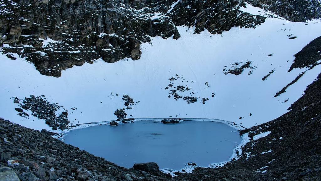
Nestled deep in the pristine Garhwal Himalayas of Uttarakhand’s Chamoli district, Roopkund (also known as the Skeleton Lake) is one of India’s most mysterious and captivating high-altitude destinations. This glacial lake, sitting at a staggering altitude of approximately 5,029 metres (16,500 feet), has puzzled scientists, historians, and travellers for decades.
What makes Roopkund truly unique is the haunting discovery made in 1942, when a British forest ranger stumbled upon hundreds of human skeletons scattered around and beneath the lake’s icy waters. To date, the skeletal remains of an estimated 600–800 people have been found here. The skeletons become visible on the surface briefly each summer when the snow melts, some still with flesh attached and remarkably well-preserved.
Surrounded by snow-clad peaks like Trishul Massif and Nanda Ghunti, and located within the Nanda Devi Biosphere Reserve, Roopkund is not just a trekking destination—it is a journey into history, faith, and legend. Whether you’re an adventure seeker, a history enthusiast, or a spiritual pilgrim, Roopkund offers an experience unlike any other in the Himalayas.
Quick Facts – Roopkund
History and Mythology: The Lake of Secrets
The Discovery of the Skeletons (1942)
The story of Roopkund’s skeletons began in 1942 when a British forest ranger named H.K. Madhwal stumbled upon hundreds of human skeletons scattered around the frozen lake. Some skeletons still had flesh clinging to the bones and were remarkably well-preserved. Initially, authorities feared these were the remains of Japanese soldiers attempting a secret invasion during World War II. However, radiocarbon dating later revealed that the remains date back to as early as 850 CE, ruling out the Japanese connection and deepening the mystery.
Scientific Discoveries
The Hailstorm Theory:
Initial studies suggested a single catastrophic event—a violent hailstorm with cricket ball-sized hail that caused fatal skull fractures. Radiocarbon dating placed this event around 800 CE.
DNA Analysis and the Mediterranean Connection:
A groundbreaking 2019 study published in Nature Communications analysed 38 skeletons and revealed astonishing findings:
- The majority had South Asian ancestry, dying around 800 CE
- 14 skeletons dating to 1800 CE shared genes with modern Greeks and Cretans
- The dead comprised diverse genetic groups, and their deaths were separated in time by as much as 1,000 years
As Eadaoin Harney, the lead author of the study, stated: “It is still not clear what happened at Roopkund Lake, but we can now be certain that the deaths of these individuals cannot be explained by a single event.”
This diversity suggests Roopkund was a pilgrimage route for centuries, attracting people from various backgrounds.
Mythology and Religious Beliefs
The Legend of King Jasdhaval
According to local folklore, Roopkund’s origins trace back to King Jasdhaval of Kanauj, who undertook a pilgrimage to Nanda Devi in the 9th century with his pregnant wife, servants, and dancers. Disregarding warnings about the sacredness of the area, the group celebrated loudly with singing and dancing, which angered the goddess. Drawing her wrath, she brought a barrage of iron hailstones that killed the entire group. Their skeletons became part of the lake.
The Curse of Nanda Devi
In villages across the region, a popular folk song tells how Goddess Nanda Devi created a hail storm “as hard as iron” which killed people winding their way past the lake. India’s second-highest mountain, Nanda Devi, is revered as a goddess, and her presence governs the rhythm of life in the Garhwal and Kumaon regions.
The Divine Origin of the Lake
According to another legend, Roopkund was created by Lord Shiva himself. After battling demons, Goddess Parvati sought to cleanse herself. Lord Shiva hit the ground with his Trishul (trident), creating a lake where she could bathe. This divine origin established Roopkund as a sacred site, but it soon became shrouded in mystery.
The Nanda Devi Raj Jat Yatra
Roopkund holds immense religious significance as part of the Nanda Devi Raj Jat Yatra, a grand pilgrimage and festival that takes place every 12 years. The three-week-long journey starts from Nauti village near Karnaprayag and goes up to Roopkund and Homekund with a four-horned sheep. This tradition symbolises accompanying the goddess Nanda Devi on her post-marital journey from her maternal home to her husband’s home, Kailash.
Religious Beliefs Today
- Sacred Pilgrimage Site: Roopkund is revered as a holy site by Hindus
- Nanda Devi Worship: The lake is closely associated with Goddess Nanda Devi
- Spiritual Retreat: The tranquil yet awe-inspiring atmosphere makes it ideal for meditation
- Raj Jat Connection: The lake is the culmination point of the grand 12-yearly yatra
- Divine Wrath Legend: Local beliefs hold that the skeletons are a reminder of the goddess’s power
Geography and Location
Location and Setting
Roopkund is situated in the Chamoli district of Uttarakhand, within the Nanda Devi Biosphere Reserve. The lake sits in a remote glacial basin at the base of steep slopes on Trisul, one of India’s highest mountains.
| Geographic Feature | Description |
|---|---|
| Altitude | 5,029 m (16,500 ft) |
| Lake Size | ~40 metres across |
| Depth | ~2 metres |
| Coordinates | Approximately 30°N, 79°E |
| Surroundings | Rock-strewn glaciers, snow-clad mountains |
Peaks Visible from the Region
| Peak Name | Description |
|---|---|
| Trishul Massif | 7,120 m, iconic three-summit peak |
| Nanda Ghunti | 6,309 m |
| Chaukhamba | Visible from higher elevations |
| Nanda Devi | Visible on clear days |
The Glacial Bowl
Roopkund fills and empties with the seasons—a glacial bowl that should not exist at this altitude. The lake is surrounded by rock-strewn glaciers and snow-clad mountains, making it a spectacular but challenging destination. For most of the year, the lake remains frozen, and the skeletons are hidden beneath the ice. Only when the snow melts in late summer and autumn do the bones become visible.
Flora and Fauna
Protected Area – Nanda Devi Biosphere Reserve
Roopkund is located within the Nanda Devi Biosphere Reserve, a UNESCO-designated protected area that harbours rich biodiversity.
Forests and Vegetation
The trek to Roopkund passes through diverse vegetation zones:
The Brahma Kamal – Sacred Flower
The region is famous for Brahma Kamal (Saussurea obvallata), Uttarakhand’s state flower, which grows only between 10,000 ft and 15,750 ft above sea level. This rare and sacred white flower is considered a divine offering and blooms during the summer months.
Wildlife
| Animal | Type | Description |
|---|---|---|
| Himalayan Monal | Bird | State bird of Uttarakhand, with its iridescent plumage |
| Himalayan Black Bear | Mammal | Occasionally spotted |
| Snow Leopard | Mammal | Rare and elusive |
| Serow | Mammal | Himalayan goat-antelope |
| Himalayan Deer | Mammal | Found in the region |
| Cheer Pheasant | Bird | Himalayan bird species |
| Fork-tailed Himalayan Magpie | Bird | Spotted on rhododendron branches |
Bugyals – The Alpine Meadows
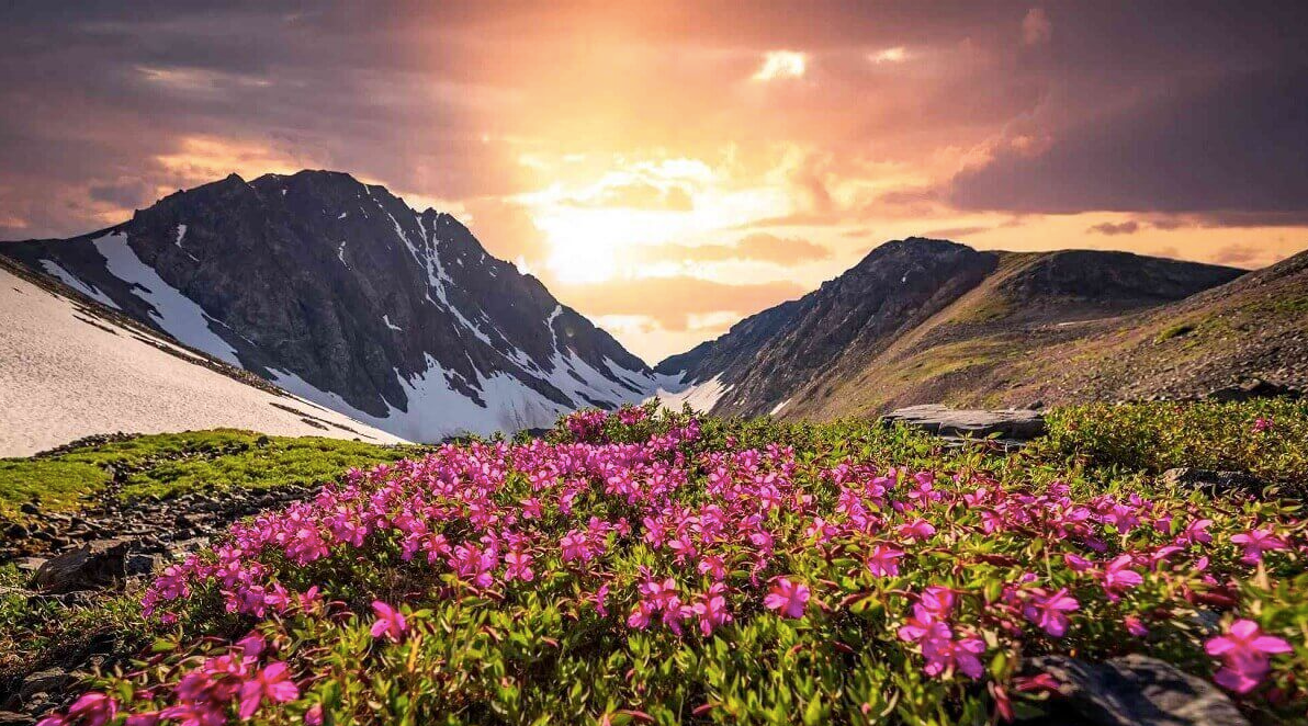
The trek passes through Ali Bugyal and Bedni Bugyal, two of Asia’s largest alpine meadows. These vast, undulating grasslands at nearly 12,000 feet are carpeted with multicoloured flowers during the summer months and offer panoramic views of the Trishul massif and Nanda Ghunti.
How to Reach Roopkund
By Air
| Details | Information |
|---|---|
| Nearest Airport | Jolly Grant Airport, Dehradun |
| Distance to Lohajung | ~250 km |
| Travel Time | 10–12 hours by taxi |
| Airlines | Regular flights from Delhi to Dehradun (approx. 1 hour) |
| Onward Travel | Taxis available from the airport to Lohajung |
By Train
| Details | Information |
|---|---|
| Nearest Station | Kathgodam Railway Station |
| Distance to Lohajung | ~220 km |
| Travel Time | 8 hours by taxi |
| Connectivity | Well-connected from Delhi |
Popular Trains from Delhi to Kathgodam:
| Train Name | From Delhi | Departure | Arrival | Destination |
|---|---|---|---|---|
| Kathgodam Shatabdi | Delhi | 6:20 AM | 11:35 AM | Kathgodam |
| Ranikhet Express | Delhi | 10:10 PM | 6:00 AM | Kathgodam |
By Road
Route to Lohajung (Base Camp for Roopkund Trek):
The Trekking Route
Base Camp: Lohajung (2,300 m / 7,650 ft) is the base camp for the Roopkund trek.
Trek Route and Itinerary:
Total Trek Distance: ~53 km round trip
Optional Extension: Junargali Pass (adds technical difficulty, weather permitting)
Note: As of 2026, all Roopkund trekkers are required to register through the Uttarakhand Forest Department’s online portal before commencing the trek.
Weather and Best Time to Visit
Climate Overview
Roopkund experiences a harsh high-altitude alpine climate. At 5,029 metres, the region remains snowbound for most of the year, and the lake is only accessible during two short trekking windows.
Month-by-Month Guide
Best Time to Visit by Season
Why Visit in Summer (Mid May–Mid June)
- Pleasant daytime temperatures with clear skies
- Snow patches on the trail add to the scenic beauty
- Meadows begin to bloom with vibrant colours
- Ideal for first-time trekkers to the region
- Clear views of the Himalayan peaks
Why Visit in Autumn (Mid September–Mid-October)
- Post-monsoon clarity with stable weather
- Skeletons are visible as the snow melts around the lake
- Best for photography with crystal-clear skies
- Fewer crowds compared to summer
- Crisp, invigorating mountain air
Why Avoid Monsoon (July–August)
- Heavy rainfall makes trails slippery and dangerous
- High risk of landslides
- Cloud cover obscuring mountain views
- Not recommended for trekking
Why Avoid Winter (November–April)
- The region receives heavy snowfall
- Trails are completely covered and inaccessible
- Extreme cold makes trekking impossible
- High risk of avalanches
Nearby Places to Visit
Detailed Descriptions
Ali Bugyal: One of the largest alpine meadows in Asia, Ali Bugyal is a vast expanse of rolling grasslands at approximately 3,300 metres. The meadow offers breathtaking panoramic views of the Trishul massif and Nanda Ghunti peaks.
Bedni Bugyal: Another stunning alpine meadow located at a higher altitude, Bedni Bugyal is famous for its scenic beauty and the Nanda Devi Temple located nearby. It serves as a camping site on the Roopkund trek.
Wan Village: The last village on the trek route, Wan, offers a glimpse into the local Garhwali culture and lifestyle. It is surrounded by dense oak and rhododendron forests.
Lohajung: The base camp for the Roopkund trek, Lohajung is a small village situated at 2,300 metres. It serves as the starting point for the adventure and offers basic accommodation facilities.
Distance from Major Cities
Travel Tips and Important Information
Before You Go
- Physical Fitness: The Roopkund trek is moderate to difficult and requires genuine physical preparation. A minimum of two or three prior Himalayan treks at 10,000+ feet is strongly recommended.
- Check Weather: Only trek during the designated windows (May–June & September–October).
- Permits: As of 2026, all Roopkund trekkers must register online through the Uttarakhand Forest Department’s portal. Permits can also be arranged through a trekking agency.
- Carry Cash: No ATMs near the trek route; bring sufficient cash from Kathgodam or Rishikesh.
- Mobile Network: No connectivity in the high-altitude areas; inform family of your travel plans.
- Advance Booking: Essential for accommodations and permits during the peak season.
- Hire a Registered Guide: Essential for navigating the challenging terrain and for legal compliance.
During Your Visit
- Dress in Layers: Even in summer, temperatures can drop significantly at higher altitudes.
- Stay Hydrated: Carry sufficient water; water sources may be limited at higher altitudes.
- Acclimatise: Proper acclimatisation at Lohajung and intermediate camps is essential to avoid altitude sickness.
- Start Early: Begin trekking early in the morning to avoid afternoon weather changes.
- Leave No Trace: Follow principles to preserve the fragile Himalayan ecosystem.
- Respect Local Customs: The area is considered sacred; maintain silence at the lake.
Safety Tips
- Altitude Awareness: At 5,029 m, altitude sickness is a serious risk; ascend gradually and stay hydrated.
- Glacier Trekking: The terrain includes rocky and icy sections; requires proper equipment and experience.
- Weather Changes: Weather can change rapidly in the high Himalayas; be prepared for sudden storms.
- Group Trek: Recommended to trek with an experienced group and a registered guide.
- Wildlife: Maintain a safe distance from wildlife; do not feed animals.
Packing Checklist
Accommodation Options
Photography Tips
- Best Spots: Roopkund Lake, Ali Bugyal, Bedni Bugyal, Bhagwabasa rock shelters
- Best Time: Early morning for clear mountain views; golden hour (4:00–5:30 PM)
- Camera Gear: Carry extra batteries—cold drains them quickly
- Skeleton Photography: The skeletons are most visible in late September to October when the snow melts
Frequently Asked Questions (FAQs)
Q1: What is Roopkund famous for?
A: Roopkund is famous as the “Skeleton Lake” of India, known for the hundreds of human skeletons found scattered around and beneath its icy waters. It is also renowned for its challenging high-altitude trek and stunning Himalayan views.
Q2: What is the best time to visit Roopkund?
A: The best time to visit is Mid May to Mid June (summer) and Mid September to Mid October (autumn). These months offer stable weather and clear skies.
Q3: How far is Roopkund from Delhi?
A: The distance from Delhi to Lohajung (base camp) is approximately 486 km by road, with a travel time of 14–16 hours.
Q4: How do I reach Roopkund?
A: By road to Lohajung (base camp), then a multi-day trek through Ali Bugyal, Bedni Bugyal, and Bhagwabasa. The nearest airport is Jolly Grant Airport, Dehradun, and the nearest railway station is Kathgodam (~220 km from Lohajung).
Q5: What is the altitude of Roopkund?
A: Roopkund is situated at an altitude of approximately 5,029 metres (16,500 feet) above sea level.
Q6: What is the mystery of the skeletons at Roopkund?
A: The skeletons were discovered in 1942 by a British forest ranger. Studies reveal they belong to different genetic groups—some South Asian (dated ~800 CE) and some Mediterranean (dated ~1800 CE). Their deaths were separated in time by as much as 1,000 years.
Q7: Is the Roopkund trek difficult?
A: Yes, the trek is considered moderate to difficult. It requires excellent physical fitness and prior high-altitude trekking experience.
Q8: How long does the Roopkund trek take?
A: The trek takes approximately 6–8 days from Lohajung. The total trekking distance is approximately 53 km round trip.
Q9: Do I need a permit to visit Roopkund?
A: Yes, as of 2026, all Roopkund trekkers are required to register through the Uttarakhand Forest Department’s online portal before commencing the trek.
Q10: What is the Nanda Devi Raj Jat Yatra?
A: It is a grand pilgrimage and festival that takes place every 12 years, starting from Nauti village and going up to Roopkund and Homekund.
Q11: What is the legend of King Jasdhaval?
A: According to local folklore, King Jasdhaval of Kanauj undertook a pilgrimage with his entourage. They angered Goddess Nanda Devi by celebrating loudly, and she sent a barrage of iron hailstones that killed them all.
Q12: Can beginners attempt the Roopkund trek?
A: Not recommended. The trek requires at least two or three prior Himalayan treks at 10,000+ feet. Beginners should start with easier treks like Chopta-Tungnath-Chandrashila.
Q13: What peaks are visible from Roopkund?
A: Trishul Massif (7,120 m) and Nanda Ghunti (6,309 m) are prominently visible. Chaukhamba and Nanda Devi are also visible on clear days.
Q14: Is Roopkund accessible during winter?
A: Winter (November–April) is not recommended due to heavy snowfall, extreme cold, and inaccessible trails.
Q15: What is the Brahma Kamal?
A: The Brahma Kamal is Uttarakhand’s state flower, a rare and sacred white flower that grows only between 10,000 ft to 15,750 ft above sea level.
Q16: What accommodation is available at Roopkund?
A: There are no permanent shelters at the lake. Camping is the primary accommodation along the trek route. Guesthouses are available at Lohajung.
Q17: What wildlife can I see at Roopkund?
A: The region is home to the Himalayan Monal (state bird), Himalayan Black Bear, Snow Leopard, Serow, and various bird species.
Q18: What is the best time to see the skeletons?
A: The skeletons are most visible in late September to October when the snow melts around the lake.
Q19: What is the total trekking distance?
A: The total trekking distance from Lohajung to Roopkund and back is approximately 53 km.
Q20: What is the cost of the Roopkund trek?
A: Trek costs vary depending on the operator, duration, and inclusions. Packages typically range from ₹13,999 to ₹25,000+ for a 6–8 day trek.
Plan Your Roopkund Journey with Discover Uttarakhand
At Discover Uttarakhand, we’ve been organising unforgettable journeys across Devbhoomi since 1997. As a trusted local operator with deep knowledge of the Garhwal Himalayas, we offer:
✅ Customized Roopkund trekking packages (6 to 9 days)
✅ Combined itineraries covering Roopkund, Ali Bugyal, Bedni Bugyal, and Homekund
✅ Comfortable transport with experienced hill drivers
✅ Verified accommodations in Lohajung
✅ Experienced registered local guides for the trek
✅ Camping equipment and arrangements
✅ Permit registration through the Forest Department’s online portal
✅ 24/7 customer support throughout your journey
Recommended Roopkund Packages
| Package | Duration | Starting Point | Highlights |
|---|---|---|---|
| Roopkund Trek | 6 Nights / 7 Days | Rishikesh | Lohajung, Ali Bugyal, Bedni Bugyal, Roopkund Lake, skeletons |
| Roopkund & Homekund | 7 Nights / 8 Days | Rishikesh | Roopkund, Homekund, Junargali Pass, glacial lakes |
| Roopkund with Ronti Saddle | 8 Nights / 9 Days | Rishikesh | Roopkund, Ronti Saddle, panoramic Himalayan views |
Book Your Roopkund Journey Today
Discover one of Uttarakhand’s most mysterious and challenging Himalayan treks—where centuries-old skeletons lie frozen in time, where Goddess Nanda Devi’s legend echoes through the mountains, where the Brahma Kamal blooms in divine silence, and where every step brings you closer to the untamed soul of the Garhwal Himalayas.
📞 Call / WhatsApp: +91-9997187178, 9760222178, 8171977178
📍 Visit Our Office: Himalayan Colony, opposite DSVV, Haripur Kalan, Haridwar, Motichur Range, Uttarakhand 249411
🌐 Website: www.discover-uttarakhand.com
📧 Email: info@discover-uttarakhand.com
Discover Uttarakhand – Your Local Partner for Unforgettable Himalayan Journeys Since 1997 🏔️💀