Introduction: The Sacred Lake Hidden in the Himalayas
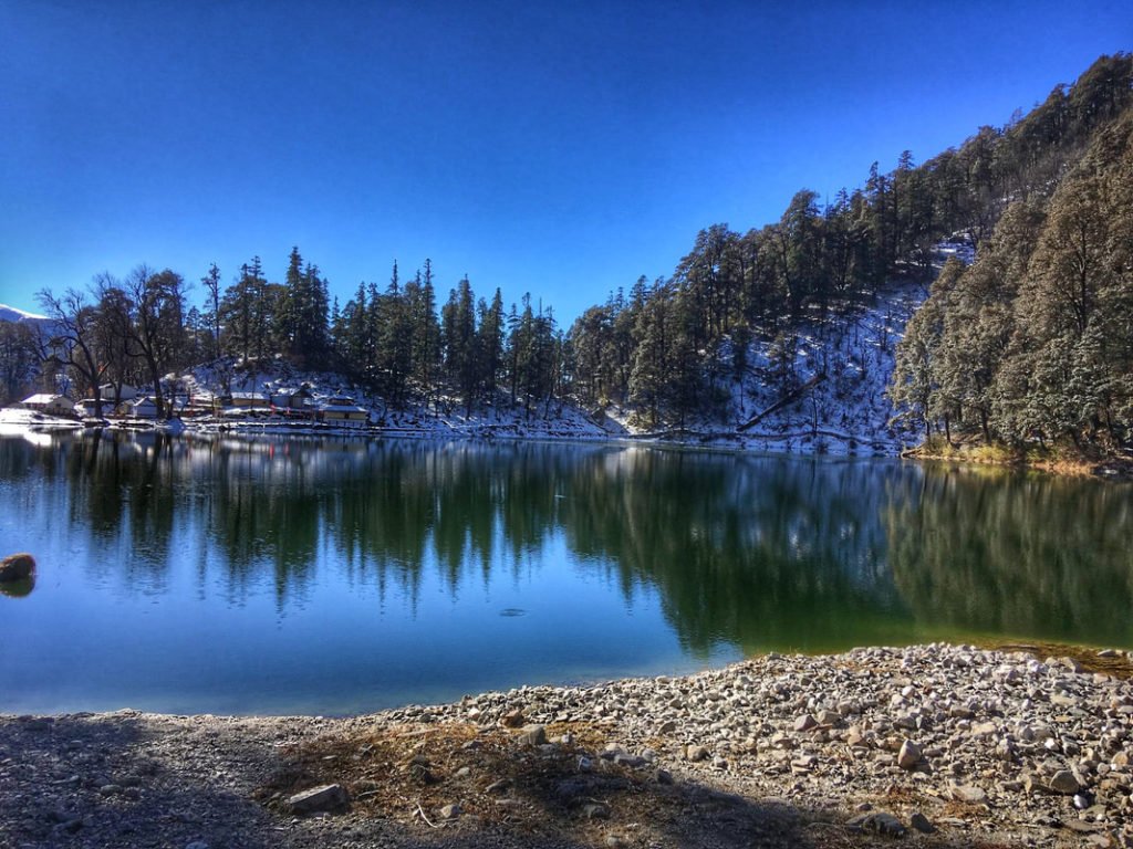
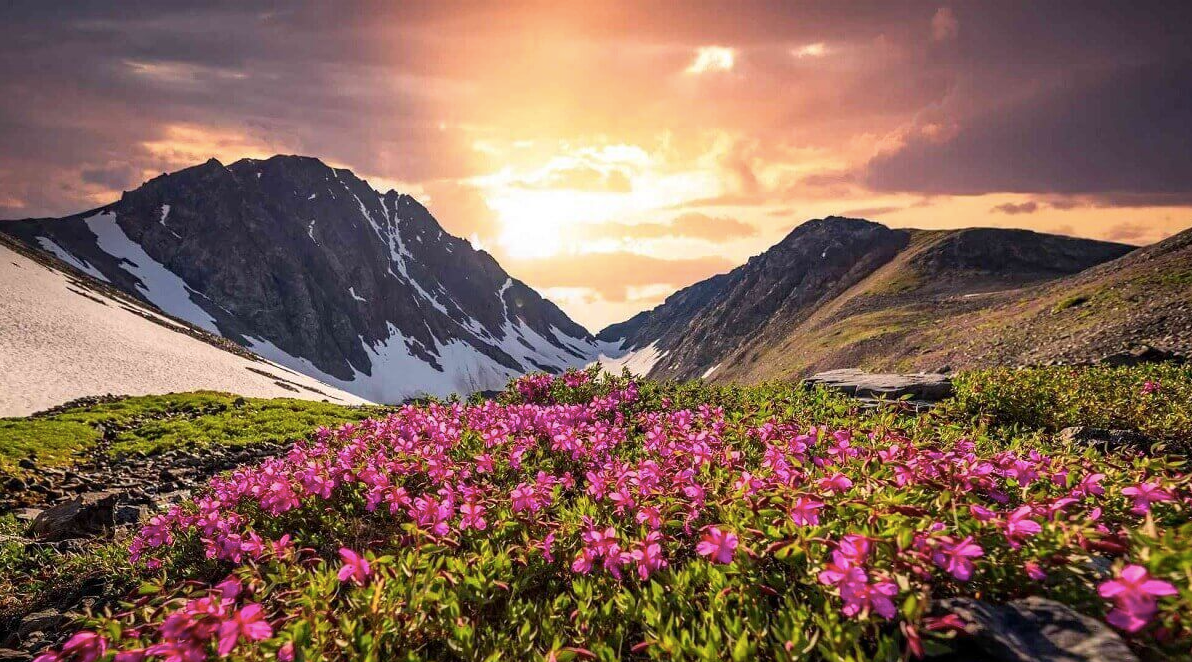
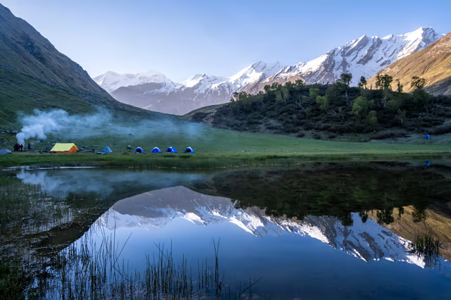
Nestled in the Garhwal Himalayas of Uttarakhand’s Uttarkashi district, at an altitude of approximately 3,500–3,600 metres (11,480–11,811 feet), Ruinsara Tal is a pristine high-altitude glacial lake that remains one of the most serene and offbeat trekking destinations in India. This emerald lake, fed by the Ruinsara Gad stream originating from the majestic Swargarohini peaks, is surrounded by lush alpine meadows, dense rhododendron forests, and towering snow-capped peaks, including Swargarohini, Bandarpoonch, and Kalanag (Black Peak).
What makes Ruinsara Tal truly special is its seclusion. While the neighbouring Har Ki Dun Valley has become increasingly popular, the moment you turn off the main trail towards Ruinsara Tal, the crowds vanish completely. The lake is considered sacred by the local communities, who believe it to be connected to the Mahabharata—it is said that Yudhisthira, the eldest Pandava, passed through this route on his journey to heaven. The Osla villagers still worship the lake as a centre of spiritual significance.
Whether you are a seasoned trekker seeking a moderate Himalayan adventure, a nature lover drawn to untouched alpine meadows and glacial rivers, a birdwatcher hoping to spot the Himalayan Monal, or a photographer chasing the perfect reflection of snow-capped peaks in crystal-clear waters, Ruinsara Tal promises an experience that will stay with you forever.
Key Information at a Glance:
| Aspect | Details |
|---|---|
| Location | Uttarkashi district, Uttarakhand |
| Altitude | 3,500–3,600 m (11,480–11,811 ft) |
| Also Known As | Ruinsara Lake |
| Trek Distance | 34–62 km (round trip, varies by route) |
| Trek Duration | 7–9 days |
| Difficulty | Moderate |
| Starting Point | Sankri village |
| Base Village | Taluka (trek start) |
| Best Season | May–June & September–October |
| Nearest Airport | Jolly Grant Airport, Dehradun (~190 km) |
| Nearest Railway Station | Dehradun (~190 km) |
| Distance from Delhi | ~450 km |
History and Mythology: Where Legends Meet the Mountains
Ancient Trade Routes
The region surrounding Ruinsara Tal was once part of ancient trade routes connecting Tibet to India. For centuries, traders, pilgrims, and locals traversed these high-altitude passes, carrying goods and stories across the Himalayas. The trail itself is one of the most ancient Himalayan routes in Uttarakhand.
The Mahabharata Connection
According to Hindu mythology, the Swargarohini peaks visible from the Ruinsara Valley are believed to be the path taken by the Pandavas on their final journey to heaven. Some legends say that Yudhisthira, the eldest Pandava brother, passed through the Ruinsara Lake route while attempting to reach the road to heaven. The local communities of the Har Ki Dun valley revere Ruinsara Tal and consider it sacred.
The Pandava and Kaurava Legacy
The nearby Osla village holds unique cultural significance—the locals worship the Kauravas instead of the Pandavas, and a temple dedicated to Duryodhana stands in the village. According to old beliefs, the Pandavas had gone through the Har Ki Dun valley to reach the Swargarohini peak, and Ruinsara Lake symbolises a centre of worship for the Osla villagers.
Geography and Location
Location and Setting
Ruinsara Tal is located in the Uttarkashi district of Uttarakhand, deep within the Govind Pashu Vihar National Park (also known as Govind Wildlife Sanctuary) . The lake lies at the foot of the Swargarohini peaks, surrounded by lush green meadows and mountain ranges. The site offers beautiful views of the valley, Kalanag, and Bandarpoonch ranges.
| Feature | Detail |
|---|---|
| Region | Garhwal Himalayas |
| District | Uttarkashi |
| Nearest Village | Osla (24 km from Sankri) |
| River | Ruinsara Gad (feeds the lake) |
| Glacial Origin | Swargarohini peaks |
The Ruinsara Valley
The Ruinsara Valley is located south of the Har Ki Dun Valley. The trek to Ruinsara Tal takes you through a variety of terrains—dense pine and deodar forests, alpine meadows, glacial river crossings, and traditional Himalayan villages. The valley is home to rich biodiversity, including dense forests of rhododendrons, Bhojpatra (birch), oak, and maple.
Flora and Fauna
Protected Area Status
The Ruinsara Tal trek passes through the Govind Pashu Vihar National Park, a biodiversity hotspot that is also part of the Rajaji National Park ecosystem. The sanctuary is known for its rich flora and fauna, including endangered species like the Himalayan Monal and the snow leopard.
Forests and Vegetation
The trail passes through diverse ecological zones :
| Zone | Vegetation | Characteristics |
|---|---|---|
| Lower Forests | Pine, Deodar, Walnut, Chestnut | Dense forests, rich birdlife |
| Mid-Altitude | Rhododendron, Oak, Maple | Vibrant colours in spring |
| High Altitude | Birch (Bhojpatra), Fir, Alpine Meadows | Treeline transition, stunning vistas |
The forest walk from Boslo towards Ruinsara Tal is particularly magical, with tall pines forming a green canopy and a well-marked trail making its way through shrubs and bushes. The landscape steadily changes from pine and fir to birch and rhododendron as you climb higher.
Wildlife
| Species | Status | Likelihood of Sighting |
|---|---|---|
| Snow Leopard | Endangered | Extremely rare |
| Himalayan Black Bear | Vulnerable | Rare |
| Musk Deer | Endangered | Rare |
| Blue Sheep | Schedule I | Uncommon |
| Himalayan Monal | State bird of Uttarakhand | Moderate |
| Bearded Vulture | High-altitude scavenger | Occasional |
| Steppe Eagle | Migratory | Occasional |
Birdwatchers can spot species like monal pheasant, steppe eagle, and bearded vulture along the trail.
The Ruinsara Tal Trek: Complete Guide
Trek Overview
| Aspect | Details |
|---|---|
| Starting Point | Sankri village (1,920 m / 6,300 ft) |
| Trek Distance | 34–62 km (round trip, depending on route) |
| Trek Duration | 7–9 days |
| Maximum Altitude | 3,600 m (11,811 ft) |
| Difficulty | Moderate |
| Best Time | May–June & September–October |
| Trail Type | Forest paths, river crossings, alpine meadows |
Day-by-Day Itinerary (9 Days)
Day 1: Dehradun to Sankri (210 km, 7–8 hours drive)
| Aspect | Details |
|---|---|
| Altitude | Dehradun: 450 m → Sankri: 1,920 m |
| Route | Dehradun → Mussoorie → Purola → Mori → Sankri |
| Overnight | Sankri (homestay/guesthouse) |
Highlights:
- Scenic drive through the Tons River valley
- Last ATM at Purola—withdraw cash here
- BSNL is the only reliable network in Sankri
- Overnight at a homestay or guesthouse
Day 2: Sankri to Taluka (Drive) – Trek to Seema (12–14 km, 5–6 hours)
| Aspect | Details |
|---|---|
| Drive | Sankri → Taluka (11 km, 1 hour, rough road) |
| Trek Distance | 12–14 km |
| Trek Duration | 5–6 hours |
| Altitude | 2,700 m |
| Overnight | Seema (camp) |
Highlights:
- Trek beside the Supin River under the shade of pine and walnut trees
- Cross small streams that merge into the Supin River
- Pass through Gangad village
Day 3: Seema to Devsu Bugyal (7–8 km, 3–4 hours)
| Aspect | Details |
|---|---|
| Trek Distance | 7–8 km |
| Trek Duration | 3–4 hours |
| Altitude | 3,000 m |
| Overnight | Devsu Bugyal (camp) |
Highlights:
- Trek through beautiful meadows with views of snow-covered peaks
- Devsu Bugyal is a multi-level meadow—the best campsite on the trek
Day 4: Devsu Bugyal to Ruinsara Tal (12–16 km, 5–7 hours)
| Aspect | Details |
|---|---|
| Trek Distance | 12–16 km |
| Trek Duration | 5–7 hours |
| Altitude | 3,600 m |
| Overnight | Ruinsara Tal (camp) |
Highlights:
- Steep but rewarding trail leading to the serene lake
- Traverse through terraced fields, lush meadows, and conifer forests
- Arrive at Ruinsara Tal, surrounded by vast meadows and rhododendron bushes
- This is the highlight of the entire trek
Day 5: Rest Day at Ruinsara Tal
| Overnight | Ruinsara Tal (camp) |
Activities:
- Explore the lake and its surroundings
- Climb the small ridge beside the lake for a panoramic view of the wide river basin on the other side
- Photography and meditation
- Optional: Explore trails leading to Black Peak or Bali Pass
Day 6: Ruinsara Tal to Devsu Bugyal (12 km, 5–6 hours)
| Aspect | Details |
|---|---|
| Trek Distance | 12 km |
| Trek Duration | 5–6 hours |
| Overnight | Devsu Bugyal (camp) |
Highlights:
- Return trek through the same trail
- Enjoy the stunning views of the Ruinsara Valley one last time
- The descent offers different perspectives of the landscape
Day 7: Devsu Bugyal to Seema (17–18 km, 6–7 hours)
| Aspect | Details |
|---|---|
| Trek Distance | 17–18 km |
| Trek Duration | 6–7 hours |
| Altitude | 2,700 m |
| Overnight | Seema (camp) |
Highlights:
- Return through the meadows and forests
- Enjoy the river views one last time
Day 8: Seema to Taluka to Sankri (12 km trek + 11 km drive)
| Aspect | Details |
|---|---|
| Trek Distance | 12 km |
| Trek Duration | 4–5 hours |
| Drive | Taluka → Sankri (11 km, 1 hour) |
| Overnight | Sankri (homestay) |
Highlights:
- Final descent through the beautiful forests
- Return to Taluka and drive back to Sankri
Day 9: Sankri to Dehradun (210 km, 7–8 hours drive)
- Drive back to Dehradun
- Trek concludes
Combined Har Ki Dun – Ruinsara Tal Trek (Extended)
Many trekkers combine the Har Ki Dun valley with Ruinsara Tal for a more complete experience. The combined trek typically takes 9–10 days and adds the “Valley of Gods” to the itinerary.
Why Combine:
- While Har Ki Dun is beautiful, it sees a lot of footfall. The moment you turn off the main Har Ki Dun trail towards Ruinsara Tal, the crowd vanishes completely
- Har Ki Dun and Ruinsara Tal are two sides of the same mountain region—they are very different and complement each other fully
- The additional day spent doing both valleys is worth its weight in gold
How to Reach Ruinsara Tal
By Air
Nearest Airport: Jolly Grant Airport, Dehradun
| Details | Information |
|---|---|
| Distance | ~190 km to Sankri |
| Travel Time | 7–8 hours by taxi |
| Airlines | Regular flights from Delhi to Dehradun (approx. 1 hour) |
| Onward Travel | Taxis available from the airport to Sankri |
By Train
Nearest Railway Station: Dehradun
| Details | Information |
|---|---|
| Distance | ~190 km to Sankri |
| Travel Time | 7–8 hours by taxi |
| Connectivity | Well-connected from Delhi, Mumbai, Kolkata |
Popular Trains from Delhi to Dehradun:
| Train Name | From Delhi | Departure | Arrival (Dehradun) | Duration |
|---|---|---|---|---|
| Shatabdi Express | Delhi | 6:00 AM | 11:40 AM | 5h 40m |
| Jan Shatabdi | Delhi | 3:20 PM | 9:00 PM | 5h 40m |
| Mussoorie Express | Delhi | 10:05 PM | 5:30 AM | 7h 25m |
By Road
Route from Delhi:
Delhi → Haridwar → Rishikesh → Dehradun → Mussoorie → Naugaon → Purola → Mori → Netwar → Sankri
| Starting Point | Distance | Travel Time | Route |
|---|---|---|---|
| Delhi | ~450 km | 12–14 hours | Delhi → Meerut → Muzaffarnagar → Roorkee → Haridwar → Rishikesh → Dehradun → Mussoorie → Purola → Mori → Sankri |
| Dehradun | 210 km | 7–8 hours | Dehradun → Mussoorie → Purola → Mori → Sankri |
| Haridwar | 230 km | 8–9 hours | Haridwar → Rishikesh → Dehradun → Mussoorie → Purola → Mori → Sankri |
Road Conditions: The route is scenic but winding. The drive from Dehradun to Sankri is approximately 7–8 hours. The last 11 km from Sankri to Taluka is a rough road requiring a sturdy vehicle.
Distances from Major Cities
| City | Distance (km) |
|---|---|
| Delhi | ~450 |
| Dehradun | 210 |
| Haridwig | 230 |
| Rishikesh | 220 |
| Sankri (base) | 0 |
| Taluka | 11 km drive |
Weather and Best Time to Visit
Climate Overview
The Ruinsara Tal region experiences a high-altitude alpine climate. The area is accessible for approximately 7 months a year, from March to November.
Month-by-Month Guide
| Month | Season | Conditions | Suitability |
|---|---|---|---|
| April | Spring | Snow melting, trails opening | ⭐ Good |
| May | Summer | Pleasant days (10–15°C), cold nights (0–5°C) | ⭐ Best |
| June | Summer | Pleasant, clear skies | ⭐ Best |
| July | Monsoon | Heavy rain, landslides, leeches | ❌ Avoid |
| August | Monsoon | Heavy rain, slippery trails | ❌ Avoid |
| September | Autumn | Crisp weather, clear skies (5–10°C days) | ⭐ Best |
| October | Autumn | Clear skies, stunning views | ⭐ Best |
| November–March | Winter | Freezing conditions, heavy snowfall | ❌ Closed |
Best Time to Visit by Season
| Season | Months | Suitability | Conditions | Best For |
|---|---|---|---|---|
| Summer | May–June | ⭐ Best | 10°C–15°C days, 0–5°C nights, clear skies | Trekking, photography, camping |
| Autumn | September–October | ⭐ Excellent | 5°C–10°C days, clear skies, golden meadows | Photography, clear mountain views |
| Monsoon | July–August | ❌ Avoid | Heavy rainfall, landslides, slippery trails | Not recommended |
| Winter | November–April | ❌ Closed | Below freezing, heavy snow, routes blocked | Not accessible |
Weather During Summer (May–June)
- Days: 10°C–15°C – pleasant and comfortable for trekking
- Nights: 0°C–5°C – cold but manageable with proper gear
- Best for: First-time trekkers, families, clear mountain views
Weather During Autumn (September–October)
- Days: 5°C–10°C – crisp and invigorating
- Nights: -5°C or lower – cold; carry heavy woolens
- Best for: Photography, golden meadows, clear Himalayan views
Why Avoid Monsoon (July–August)
- Heavy rainfall makes trails slippery and dangerous
- High risk of landslides and road blockages
- Cloud cover obscures mountain views
- Leech presence in forested sections
Winter Closure (November–April)
- The region experiences heavy snowfall, making trails difficult to navigate
- The route is closed due to extreme cold and snow
- Do not attempt the trek during winter without expert guidance
Things to Do at Ruinsara Tal
1. Trekking
The primary activity is the trek itself. The moderate trail takes you through dense forests, alpine meadows, and glacial river crossings before reaching the pristine lake.
2. Camping
Set up your camp near the tranquil waters of Ruinsara Tal and spend a night under the starlit sky. Camping here allows you to immerse yourself in the serene ambience of the Himalayas.
3. Photography
Whether you’re an amateur or professional photographer, Ruinsara Tal offers countless opportunities to capture stunning landscapes, vibrant flora, and reflections of snow-capped peaks in the crystal-clear waters.
4. Birdwatching
The region around Ruinsara Tal is home to a diverse range of bird species. Bring your binoculars and spend time observing the colourful Himalayan birds amidst the pristine natural surroundings.
5. Nature Walks
Take leisurely walks around the lake and its surroundings to appreciate the beauty of the Himalayan ecosystem. You may encounter wildflowers, cascading streams, and perhaps even some wildlife.
6. Explore the Ridge
Climb the small ridge beside the Ruinsara Tal to realise that there is a wide river basin on the other side. The view from the ridge is breathtaking and offers a different perspective of the landscape.
7. Meditation and Reflection
The lake’s serene and pristine surroundings make it an ideal spot for meditation, introspection, or simply enjoying the tranquillity of nature.
Nearby Places to Visit
| Destination | Distance | Highlights |
|---|---|---|
| Har Ki Dun Valley | Trek route | “Valley of Gods,” Swargarohini views, alpine meadows |
| Sankri Village | Base camp | Start point for treks, local culture |
| Osla Village | Trek route | Ancient wooden temple of Duryodhana, traditional architecture |
| Taluka | 11 km from Sankri | Last motorable point, start of trek |
| Govind Wildlife Sanctuary | Surrounding area | Snow leopard, Himalayan Monal, rich biodiversity |
| Chopta | 150 km | “Mini Switzerland of India,” Tungnath Temple |
| Dehradun | 190 km | Capital city, Robber’s Cave, Sahastradhara |
| Rishikesh | 200 km | River rafting, yoga, Ganga Aarti |
Har Ki Dun Valley
Har Ki Dun is a cradle-shaped hanging valley at 3,566 metres, surrounded by snow-capped peaks including the majestic Swargarohini massif. It is also known as the “Valley of Gods” and is believed to be the route taken by the Pandavas on their journey to heaven.
Osla Village
Osla village is one of the most culturally significant villages on the route. It is famous for its ancient wooden temple dedicated to Duryodhana, where the local people worship the Kauravas instead of the Pandavas.
Govind Wildlife Sanctuary
The trek passes through the Govind Pashu Vihar National Park, a haven for wildlife enthusiasts. The sanctuary covers an area of about 472 square kilometres and is home to diverse species such as the Himalayan black bear, musk deer, snow leopard, and the Himalayan Monal.
Where to Stay: Accommodation Options
In Sankri (Base Camp)
| Category | Price Range | Features |
|---|---|---|
| Homestays | ₹1,000–2,500 | Authentic Garhwali experience, home-cooked meals |
| Guesthouses | ₹800–1,800 | Basic amenities, clean rooms |
| Tented Camps | ₹1,500–3,000 | Organised by trek operators, a camping experience |
On the Trek
| Location | Accommodation Type | Features |
|---|---|---|
| Seema | Tented Camp | Riverside campsite |
| Devsu Bugyal | Tented Camp | Alpine meadow campsite—the best campsite on the trek |
| Ruinsara Tal | Tented Camp | Lake-side camping |
In Dehradun (Before/After Trek)
| Category | Price Range | Features |
|---|---|---|
| Luxury Hotels | ₹6,000–15,000+ | Premium amenities |
| Mid-Range Hotels | ₹2,000–5,000 | Comfortable rooms |
| Budget Hotels | ₹800–2,000 | Basic amenities |
Booking Tips
- Book well in advance for peak season (May–June, September–October)
- Most trek packages include accommodation, meals, a guide, and camping equipment
- For stays at the Sankri homestay, book through trek operators or local contacts
- Carry cash—card facilities are limited in Sankri
Essential Packing List
Clothing (Layering System)
| Layer | Items | Quantity |
|---|---|---|
| Base Layer | Thermal innerwear (top & bottom) | 2 sets |
| Mid Layer | Fleece jacket, woollen sweater | 1–2 each |
| Outer Layer | Down jacket, waterproof windcheater | 1 each |
| Bottoms | Trekking pants (quick-dry) | 2 pairs |
| Head | Woollen cap, sun hat | 1 each |
| Hands | Waterproof gloves | 2 pairs |
| Feet | Woollen socks | 4–5 pairs |
Footwear
- Trekking shoes: Sturdy, waterproof, high ankle support, broken-in
- Camp shoes: Sandals or floaters for evening
Gear and Accessories
Health and Hygiene
| Category | Items |
|---|---|
| First Aid | Bandages, antiseptics, and pain relievers |
| Medications | Personal prescription medicines, Diamox (consult doctor) |
| Hygiene | Wet wipes, hand sanitizer, toilet paper |
| Sun Protection | Sunscreen (SPF 50+), lip balm |
Documents and Other Essentials
- Valid ID proof (Aadhaar/Passport)
- Travel insurance
- Cash (no ATMs on the trek)
- Power bank
- Camera with extra batteries
- Energy bars, dry fruits, ORS packets
Travel Tips and Important Information
Before You Go
- Physical Fitness: The Ruinsara Tal trek is moderate and suitable for beginners with good fitness. Prepare with regular walking for 4–6 weeks before.
- Medical Check-up: Consult your doctor before undertaking high-altitude trekking, especially if you have heart or respiratory conditions.
- Check Weather: Avoid monsoon (July–August); the trek is closed in winter (November–April).
- Advance Booking: Essential for peak season (May–June, September–October). Trek packages range from ₹12,000 to ₹ 18,000 per person.
- Carry Cash: No ATMs beyond Purola; bring sufficient cash from Dehradun.
During the Trek
- Acclimatise: The gradual ascent on the trek allows for natural acclimatisation.
- Stay Hydrated: Drink plenty of water to prevent altitude sickness.
- Dress in Layers: Temperatures can change rapidly; layers allow adjustment.
- Start Early: Begin each day’s trek early to complete sections before afternoon weather changes.
- Hire a Guide: For safety and cultural insights, hiring a local guide is recommended.
- Carry a Local SIM: BSNL has limited connectivity in some areas; inform family of your travel plans.
Offloading Backpack
If you wish to offload your backpack, you can give it to a mule. Charges are approximately ₹1,200–1,500 for the entire trek. The backpack cannot weigh more than 11 kgs.
Safety Tips
- Altitude Awareness: Above 3,000 m, altitude sickness is possible. Stay hydrated, walk slowly, and descend if symptoms worsen.
- Road Safety: The route from Dehradun to Sankri is winding; avoid night driving.
- Monsoon Travel: Avoid July–August due to landslide risk.
- Wildlife: Do not feed animals; maintain a safe distance.
- Landslides: Many parts of the trail have washed off due to landslides over time; be cautious.
What to Expect at Ruinsara Tal
Responsible Tourism
- Leave No Trace: Carry back all non-biodegradable waste.
- Respect Local Customs: The Osla villagers and local communities have unique traditions; ask permission before photographing people.
- Support Local Economy: Hire local guides and porters, buy local products.
Frequently Asked Questions (FAQs)
Q1: Where is Ruinsara Tal located?
A: Ruinsara Tal is located in the Uttarkashi district of Uttarakhand, deep within the Govind Pashu Vihar National Park, at an altitude of approximately 3,500–3,600 metres (11,480–11,811 feet).
Q2: What is the best time to visit Ruinsara Tal?
A: The best time to visit is May to June (summer) and September to October (autumn). The weather is pleasant, and the skies are clear.
Q3: How difficult is the Ruinsara Tal trek?
A: The trek is graded moderate. It is suitable for beginners with good fitness and for experienced trekkers.
Q4: How long is the Ruinsara Tal trek?
A: The trek distance is approximately 34–62 km (round trip), depending on the route, and takes 7–9 days.
Q5: What is the altitude of Ruinsara Tal?
A: Ruinsara Tal is situated at an altitude of approximately 3,500–3,600 metres (11,480–11,811 feet) above sea level.
Q6: What is the starting point for the Ruinsara Tal trek?
A: The trek typically starts from the base village of Sankri, followed by a drive to Taluka, where the actual trek begins.
Q7: Is Ruinsara Tal connected to the Har Ki Dun trek?
A: Yes, the Ruinsara Tal trek is often combined with the Har Ki Dun trek as a longer circuit. Many trekkers do both valleys together over 9–10 days.
Q8: What is the mythological significance of Ruinsara Tal?
A: According to Hindu mythology, the Swargarohini peaks visible from the valley are believed to be the path taken by the Pandavas on their journey to heaven. The lake is considered sacred by locals.
Q9: What wildlife can I see on the Ruinsara Tal trek?
A: The region is home to the Himalayan black bear, musk deer, blue sheep, snow leopard (rare), Himalayan Monal (state bird), steppe eagle, and bearded vulture.
Q10: What is the cost of the Ruinsara Tal trek?
A: Packages typically range from ₹12,000 to ₹18,000 per person, depending on the operator, season, and inclusions.
Q11: Is there a mobile network on the Ruinsara Tal trek?
A: Mobile connectivity is very limited. BSNL works in some pockets. Inform family of your travel plans in advance.
Q12: Are there ATMs on the Ruinsara Tal trek?
A: No, there are no ATMs on the trek. The last ATM is at Purola. Carry sufficient cash from Dehradun.
Q13: What is the cultural significance of Osla village?
A: Osla village is famous for its ancient wooden temple dedicated to Duryodhana, where the local people worship the Kauravas instead of the Pandavas.
Q14: Can I do the Ruinsara Tal trek without a guide?
A: While experienced trekkers may attempt the route, it is not recommended due to forest regulations, remote terrain, and weather unpredictability. Local guides enhance safety and cultural understanding.
Q15: What is the Devsu Bugyal?
A: Devsu Bugyal is a beautiful multi-level meadow on the trek route—considered the best campsite on the trek. It offers a bird’s-eye view of the entire trail.
Plan Your Ruinsara Tal Journey with Discover Uttarakhand
At Discover Uttarakhand, we’ve been organising unforgettable Himalayan journeys across Devbhoomi since 1997. As a trusted local operator with deep knowledge of the Garhwal Himalayas, we offer:
- ✅ Ruinsara Tal Trek packages (8 to 10 days)
- ✅ Combined Har Ki Dun – Ruinsara Tal Trek packages (9 to 12 days)
- ✅ Complete permit assistance for Govind Pashu Vihar National Park
- ✅ Comfortable transport from Dehradun to Sankri
- ✅ Experienced local guides familiar with the region
- ✅ Camping equipment (tents, sleeping bags, meals)
- ✅ 24/7 customer support throughout your journey
Recommended Ruinsara Tal Packages
| Package | Duration | Starting Point | Highlights |
|---|---|---|---|
| Ruinsara Tal Trek (8 Days) | 7 Nights / 8 Days | Dehradun | Seema, Devsu Bugyal, Ruinsara Tal |
| Har Ki Dun – Ruinsara Tal Combo | 9 Nights / 10 Days | Dehradun | Both valleys, Osla, and Devsu Bugyal |
| Ruinsara Tal with Har Ki Dun | 8 Nights / 9 Days | Dehradun | Full circuit, complete experience |
Book your Ruinsara Tal journey today and discover one of Uttarakhand’s most sacred and pristine Himalayan lakes.
📞 Call / WhatsApp: +91-9997187178, 9760222178, 8171977178
📍 Visit Our Office: Himalayan Colony, opposite DSVV, Haripur Kalan, Haridwar, Motichur Range, Uttarakhand 249411
🌐 Website: www.discover-uttarakhand.com
📧 Email: info@discover-uttarakhand.com
Discover Uttarakhand – Your Local Partner for Unforgettable Himalayan Journeys Since 1997 🏔️