Introduction: A Valley That Reinvents Itself Every Hour
Nestled in the Western Garhwal Himalayas, the Rupin Valley is a boundless adventure trail that offers trekkers a unique opportunity to witness untouched mountain landscapes, traditional villages, and breathtaking high-altitude views. What makes this valley truly extraordinary is its ever-changing character—no two sections of the trek feel the same, yet you are constantly in awe.
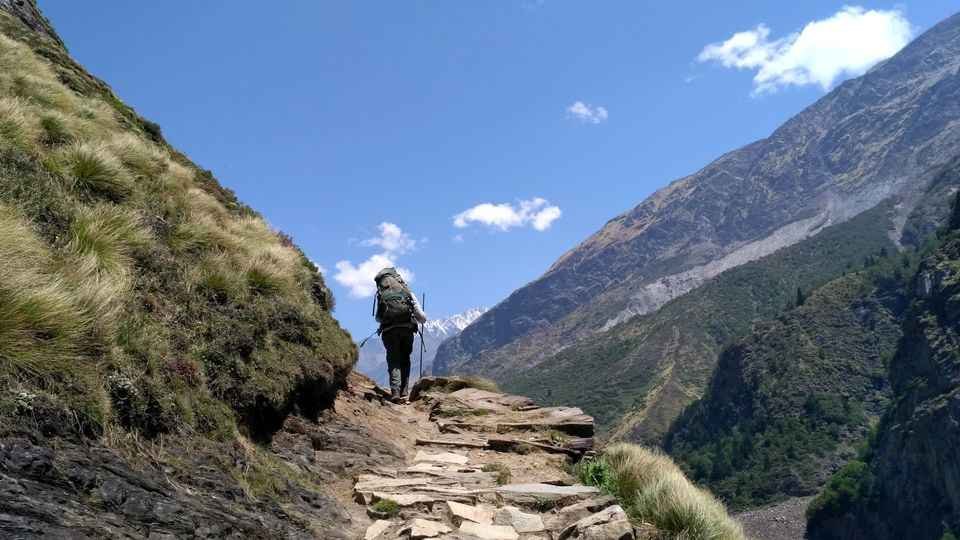
The Rupin Pass Trek is widely regarded as one of India’s most sought-after high-altitude treks, connecting the remote villages of Uttarakhand to the spectacular Kinnaur region of Himachal Pradesh. Rising to an altitude of approximately 15,250 feet (4,650 meters), this trail is a constantly changing canvas of dense pine forests, hanging villages, alpine meadows, glacial valleys, and towering snow walls.
Unlike many Himalayan treks, where the landscape remains relatively uniform, the Rupin Pass Trek surprises you every hour. From the vibrant rhododendron shrubs at Buras Kandi to the serene meadows of Saruwas Thatch, from the icy snowfields of Rata Pheri to the lush grasslands of Sangla Kanda, each day brings something dramatically different. The trek also passes through remote Himalayan hamlets like Jakha—often called the “Hanging Village” due to its dramatic cliffside location—where traditional Kath-kuni wooden architecture and local Satsangi culture provide a rich cultural immersion.
Whether you are a seasoned trekker seeking the thrill of crossing a high-altitude pass through a narrow snow gully, a nature lover drawn to cascading waterfalls and alpine wildflowers, or a cultural explorer wanting to experience life in the remote corners of the Himalayas, the Rupin Valley promises an unforgettable Himalayan journey.
Key Information at a Glance:
History and Mythology: The Ancient Shepherd and Trade Route
The Crossover Pass
Rupin Pass is one of several high-altitude passes that connect the Baspa Valley of Kinnaur (Himachal Pradesh) to the Garhwal region of Uttarakhand. For centuries, these passes were used by shepherds and traders rather than the circuitous Hindustan-Tibet road that exists today.
The route was a vital corridor for:
- Shepherds: Moving their flocks between summer and winter grazing grounds
- Traders: Carrying goods between the two distinct cultural and economic regions
- Local communities: Maintaining social and cultural ties across the mountain barrier
The Local Communities
The trail passes through the very interior villages of Uttarakhand (up to Sewa village) and then the villages of Himachal (Jiskun and Jakha). Most of the people at Jiskun and Jakha belong to the Satsangi religious sect and are pure vegetarians. Their architecture, attire, and customs have strong similarities with the Kinnaur region, reflecting the cultural blending that occurred along these historic routes.
The Name “Rupin”
The Rupin River, which gives the valley its name, is believed to be derived from a local word meaning “silver”—a fitting description for the way the river sparkles as it cascades down from the high glaciers. The river’s source lies at the base of the Rupin Pass, and the trek follows its course from its origin all the way to its confluence with other streams.
The Legend of Jakha: The Hanging Village
Jakha village, one of the highest settlements on the route, is famous for its dramatic location on a steep mountainside. Locals call it the “Hanging Village” because the houses appear to be stacked on top of one another, clinging to the slope. According to local lore, the village was founded centuries ago by a shepherd who discovered this hidden sanctuary while searching for lost sheep. The temple of Dhara Devta, located nearby, is deeply revered by locals who believe the deity protects the village from avalanches and landslides.
Geography and Location
Geographic Setting
The Rupin Valley is situated in the Western Garhwal Himalayas, straddling the border between Uttarakhand and Himachal Pradesh. The valley follows the course of the Rupin River, a tributary of the Tons River (which itself is the main tributary of the Yamuna). At Dhaula, the Supin and Rupin rivers merge to form the Tons River.
The Rupin Pass
Rupin Pass sits at an elevation of approximately 15,250 feet (4,650 meters) and serves as a bridge between the states of Uttarakhand and Himachal Pradesh. The pass is known for its dramatic landscapes, with the famous Rupin Gully—a narrow snow chute that climbers must ascend to reach the summit—being one of the most thrilling sections of the trek.
Topography
The Rupin Valley is characterised by:
| Terrain Type | Characteristics |
|---|---|
| Lower Reaches (3,000-7,000 ft) | Pine and deodar forests, terraced fields, traditional villages |
| Mid Altitudes (7,000-10,000 ft) | Rhododendron forests, meadows (thatch), waterfalls |
| High Altitudes (10,000-15,250 ft) | Alpine meadows, moraines, snowfields, glaciers |
The landscape is defined by the Rupin River, which carves through the valley, creating gorges, cascades, and the famous 1,500-ft Rupin Waterfall. The route is typically rich in wildflowers, especially just after the monsoon, with the famous Brahma Kamal flourishing in abundance in the surrounding areas of the pass.
Flora and Fauna
Forests and Vegetation
The Rupin Valley is a biodiversity hotspot, with vegetation zones changing dramatically with altitude:
Rhododendrons in Bloom: Buras Kandi, named after the local word for rhododendron, is famous for its abundance of these vibrant red flowers. If you are trekking in May-June, you will see these blooms in all their glory.
Brahma Kamal: This sacred flower, named after Lord Brahma, flourishes in the higher reaches of the Rupin Valley after the monsoon. It is considered highly auspicious and is a rare sight.
Wildlife
The trail passes through the Govind National Park (Govind Vanya Pashu Vihar) in its initial sections, which is rich in Himalayan wildlife. Animals that may be spotted include:
| Species | Habitat | Likelihood of Sighting |
|---|---|---|
| Himalayan Monal | Forests, meadows | Moderate (early morning) |
| Musk Deer | High-altitude forests | Rare |
| Himalayan Tahr | Rocky slopes | Rare |
| Snow Leopard | High alpine zones | Extremely rare |
| Bharal (Blue Sheep) | High-altitude meadows | Rare |
Birds
The valley is home to various Himalayan bird species, including woodpeckers, barbets, parakeets, and birds of prey like golden eagles and vultures. The best birdwatching is in the early morning hours in the forested sections.
Best Time to Visit Rupin Valley
Timing matters more on Rupin Pass than on most Himalayan treks. Snow depth, water flow, trail exposure, and weather stability change sharply month to month.
Month-by-Month Breakdown
Seasonal Comparison
| Aspect | May–June (Summer Season) | September–October (Autumn Season) |
|---|---|---|
| Trail Conditions | Snow-covered near the pass; snow bridges | Dry, firm paths; minimal snow |
| Landscape | Dramatic contrast—green valleys vs. white slopes | Clear skies, golden valleys, rugged terrain |
| Waterfalls | Strong flow from snowmelt | Manageable levels |
| Temperature (Day) | 10°C to 15°C | Mild, pleasant |
| Temperature (Night) | Quieter, especially in September | 0°C or lower |
| Crowds | Higher in June | Quieter, especially September |
| Difficulty | More challenging (snow sections) | More stable and predictable |
When Should You Trek?
Choose May–June if you want:
- A true snow trekking experience
- Dramatic landscapes with snow-covered peaks and green valleys
- The thrill of crossing snow bridges
- Rhododendrons in bloom (especially in May)
Choose September if you want:
- Clear, haze-free skies with sharp mountain views
- Safer, more stable trail conditions
- Fewer crowds and quieter trails
- The chance to see Brahma Kamal flowers
Avoid if possible: July–August (monsoon) and winter months (closed).
How to Reach the Rupin Valley
Rupin Pass is a crossover trek—it starts in Uttarakhand and ends in Himachal Pradesh, or vice versa. There are two common approaches:
Option 1: Uttarakhand Side (Start) → Himachal Side (End)
This is the more traditional approach, starting from the Garhwal region.
By Air
Nearest Airport: Jolly Grant Airport, Dehradun
| Details | Information |
|---|---|
| Distance to Base | 200–235 km to Khanyisani/Dhaula |
| Travel Time | 9–10 hours by taxi |
| Airlines | Regular flights from Delhi to Dehradun (approx. 1 hour) |
By Train
Nearest Railway Station: Dehradun Railway Station
| Details | Information |
|---|---|
| Distance | 200–235 km to base camp |
| Travel Time | 9–10 hours by taxi |
Popular Trains from Delhi to Dehradun:
| Train Name | From Delhi | Departure | Arrival (Dehradun) | Duration |
|---|---|---|---|---|
| Shatabdi Express | Delhi | 6:00 AM | 11:40 AM | 5h 40m |
| Jan Shatabdi | Delhi | 3:20 PM | 9:00 PM | 5h 40m |
| Mussoorie Express | Delhi | 10:05 PM | 5:30 AM | 7h 25m |
By Road to Base Camp
| Starting Point | Distance | Travel Time | Base Camp |
|---|---|---|---|
| Dehradun | 200–235 km | 9–10 hours | Khanyisani / Dhaula / Netwar |
| Purola | Approx. 66 km | 2–3 hours | Netwar area |
Route: Dehradun → Mussoorie → Nainbagh → Damta → Naugaon → Purola → Mori → Naitwar → Khanyisani
Road Conditions: The drive is scenic but long. Highlights include a stop at Kempty Falls for breakfast and views of the Yamuna River en route.
Option 2: Himachal Side (Start) → Uttarakhand Side (End)
This approach starts from the Shimla side and is often preferred by trekkers coming from Delhi via Kalka.
By Air
Nearest Airport: Jubbarhatti Airport, Shimla (22 km from Shimla)
By Train
Nearest Railway Station: Kalka Railway Station (the last station on the Kalka-Shimla toy train route)
By Road to Base Camp
| Starting Point | Distance | Travel Time | Base Camp |
|---|---|---|---|
| Shimla | 195 km | 8–9 hours | Bawta |
| Rohru | Approx. 100 km | 4–5 hours | Bawta area |
Route: Shimla → Kufri → Theog → Narkanda → Rampur → Rohru → Bawta
Getting Back from the Trek End Point
Since Rupin Pass is a crossover trek, you will end at a different location than where you started.
Note: Transportation costs are typically arranged by trek operators and shared among group members.
Distances from Major Cities
| City | Distance to Base (Uttarakhand side) | Travel Time |
|---|---|---|
| Delhi | ~450–500 km | 14–16 hours |
| Dehradun | 200–235 km | 9–10 hours |
| Haridwar | ~250 km | 10–11 hours |
| Rishikesh | ~240 km | 10–11 hours |
Rupin Pass Trek: Complete Itinerary
The Rupin Pass Trek typically takes 6–9 days, depending on the starting point and pace. Below is a comprehensive itinerary based on the Uttarakhand-to-Himachal route.
Trek Overview
| Aspect | Details |
|---|---|
| Total Trek Distance | 32–60 km (depending on route) |
| Maximum Altitude | 15,250 ft (4,650 m) |
| Difficulty | Moderate to Difficult |
| Suitable for | Experienced trekkers; first-timers with good fitness |
Day-by-Day Itinerary
Day 1: Drive from Dehradun to Khanyisani/Dhaula Base Camp
| Aspect | Details |
|---|---|
| Distance | 200–235 km |
| Drive Duration | 9–10 hours |
| Altitude Gain | 478 m (Dehradun) to 1,878 m (Khanyisani) |
| Accommodation | Camp or homestay |
Highlights:
- Scenic drive via Mussoorie and Kempty Falls
- Views of the Yamuna River
- Pine forests of Jarmola
- Overnight at the base camp in the Rupin Valley
Day 2: Khanyisani to Sarutal Camp
| Aspect | Details |
|---|---|
| Trek Distance | 5–8 km |
| Trek Duration | 3–4 hours |
| Altitude Gain | 1,878 m to 2,000 m |
| Accommodation | Camp |
Highlights:
- Trek following the right bank of the Rupin River
- Pass through Bitri village with its apple orchards
- Traditional wooden homes on stilts
- Beautiful valley views
Day 3: Sarutal to Badang Camp
| Aspect | Details |
|---|---|
| Trek Distance | 8 km |
| Trek Duration | 5–6 hours |
| Altitude Gain | 2,000 m to 2,600 m |
| Accommodation | Camp |
Highlights:
- Gradual ascent through pine forests
- Meadows start to appear
- Stunning views of the surrounding peaks
- Campsite in a beautiful meadow
Day 4: Badang to Pachi Thach via Vijay Top (Highest Point)
| Aspect | Details |
|---|---|
| Trek Distance | 12 km |
| Trek Duration | 6–7 hours |
| Altitude | 2,600 m → 3,800 m (Vijay Top) → 3,000 m (Pachi Thach) |
| Accommodation | Camp |
Highlights:
- Vijay Top at 3,800 m—the highest point before the pass
- Panoramic views of the Himalayan ranges
- Descend into the Supin Valley
- The crossover experience between valleys
Day 5: Pachi Thach to Fhitari Village
| Aspect | Details |
|---|---|
| Trek Distance | 7 km |
| Trek Duration | 4–5 hours |
| Accommodation | Hotel in Sankri village |
Highlights:
- Descend through pine forests
- Reach Fhitari village
- Drive 36 km to Sankri village (base for many treks)
- Overnight in a comfortable hotel
Day 6: Drive from Sankri to Dehradun
Alternative Itinerary (Himachal Side Start)
For trekkers starting from the Himachal side, the itinerary typically follows this pattern :
| Day | Segment | Distance | Altitude |
|---|---|---|---|
| 1 | Drive: Shimla → Bawta | 195 km | 2,350 m |
| 2 | Trek: Bawta → Jakha | 5 km | 2,750 m |
| 3 | Trek: Jakha → Saruwas Thatch | 8 km | 3,261 m |
| 4 | Trek: Saruwas Thatch → Dhanderas Thatch | 6 km | 3,284 m |
| 5 | Trek: Dhanderas Thatch → Upper Waterfall | 5 km | 4,000+ m |
| 6 | Trek: Upper Waterfall → Rupin Pass → Ronti Gad | 7–12 km | 4,650 m |
| 7 | Trek: Ronti Gad → Sangla → Shimla | 12 km + drive | – |
Key Highlights of the Trek
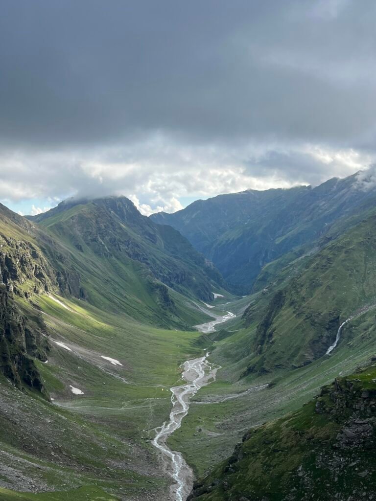
The Rupin Waterfall
One of the most spectacular sights on the trek is the Rupin Waterfall, which drops approximately 1,500 feet in three grand stages. It tumbles down from the heights as if pouring straight out of the clouds. The view opens up suddenly beyond a rhododendron forest, and the whole scene feels still, distant, and dreamlike .
The Rupin Gully
The climb to the pass through the Rupin Gully is an unforgettable adventure. The gully feels like a natural amphitheatre, with voices echoing sharply as you ascend its steep walls. The thrill of navigating this 200-meter ascent on a snowy flank is unmatched.
Dhanderas Thatch (Lower Waterfall Camp)
Among the most picturesque campsites in the Himalayas, Dhanderas Thatch is nestled in a lush green glacial valley, surrounded by snow-patched cliffs. You have a front-row view of the magnificent Rupin Waterfall cascading 1,500 feet from here.
Jakha: The Hanging Village
Jakha, the highest village on the route, is perched on a steep slope. Houses here are built so that they appear to be stacked on top of one another, creating a unique sight. The village offers a glimpse into traditional Himalayan life and culture.
Flora, Fauna, and Natural Wonders Along the Trek
The Waterfall Experience
Unlike most treks where waterfalls are seen from a distance, on the Rupin Pass Trek, you actually trek beside the cascading water for extended sections. The gushing water flows right next to the trail, creating a truly immersive experience.
Snow Bridges
During the early summer season (May–June), snow bridges form over streams and smaller waterfalls. Crossing these natural ice structures is both thrilling and requires careful navigation.
Wildflower Blooms
The route is typically rich in wildflowers, especially just after the monsoon. The famous Brahma Kamal flourishes in abundance in the surrounding areas of the pass, while lower elevations showcase a variety of alpine flowers.
Changing Landscapes
The Rupin Pass Trail is a showcase of diverse terrains:
- Buras Kandi: Vibrant rhododendron shrubs
- Saruwas Thatch: Serene meadows
- Rata Pheri: Icy snowfields
- Sangla Kanda: Lush grasslands surrounded by the Kinnaur Kailash range
Local Culture and Villages
The People of the Rupin Valley
The trail passes through the very interior villages of Uttarakhand (up to Sewa village) and then the villages of Himachal (Jiskun and Jakha). Most of the people at Jiskun and Jakha belong to the Satsangi religious sect and are pure vegetarians. Their architecture and attire have similarities with the Kinnaur region.
Traditional Architecture (Kath-Kuni)
The houses in this region are built in the traditional Kath-kuni style—crafted from deodar cedar wood. These homes are not only aesthetically beautiful but also exude a rich, woody fragrance and provide an extremely warm and comforting atmosphere. The thick wooden walls make the interiors cosy and well-insulated, perfect for the chilly mountain nights.
Bhitri Village
Bhitri village is a small but beautiful hamlet with wooden homes on stilts, a temple, and a very active cricket community. The local youth are passionate about the game and know the rules just as well as their city counterparts.
Bitari Village (Edge of the Cliff)
There is a uniquely positioned village called “Bitari village” which is at the extreme edge of a mountain cliff, offering beautiful scenery. There is a multi-floored Bitari temple where you can have a glimpse of Garhwali culture.
Local Cuisine
Food on the trek is simple, nutritious, and purely vegetarian. Most trek operators provide:
| Meal | Typical Items |
|---|---|
| Breakfast | Porridge, eggs, bread, jam, tea/coffee |
| Lunch (packed) | Parathas, fruits, energy bars |
| Evening Snacks | Pakoras, biscuits, tea |
| Dinner | Dal, rice, vegetables, roti, dessert |
Accommodation on the Trek
Types of Accommodation
What to Expect
- Tents: Four-season tents designed to withstand harsh weather conditions
- Sleeping Bags: Rated for temperatures down to -10°C
- Toilet Facilities: Separate toilet tents at each campsite
- Common Areas: Dining tent for meals and gatherings
Hygiene Considerations
If you have personal preferences, consider bringing your own sleeping bag liner for added hygiene.
Packing List for the Rupin Valley Trek
Clothing
Gear and Accessories
| Category | Items |
|---|---|
| Backpack | 20–30 litres (if offloading main bag) |
| Daypack | 20–30 liters (if offloading main bag) |
| Trekking Poles | Essential for steep ascents/descents |
| Headlamp/Torch | With extra batteries |
| Water Bottle | Unbreakable, no leaks |
| Sunglasses | UV protection (avoid blue glasses) |
| Rain Protection | Poncho or raincoat |
| Footwear for Camp | Sandals or floaters |
Health and Hygiene
| Category | Items |
|---|---|
| Medications | Personal prescription medicines, first-aid kit |
| Altitude Sickness | Diamox (consult doctor) |
| Hygiene | Wet wipes, hand sanitizer, toilet paper, small towel |
| Sun Protection | Sunscreen lotion (high SPF), lip balm |
| Hydration | Water purification tablets/filter |
Documents and Other Essentials
Weight Limits
- Personal Backpack: 10–12 kg maximum
- Offloading Option: Porter services available for an additional fee (approx. ₹400–₹600 per day)
Trekking Tips and Important Information
Physical Preparation
The Rupin Pass Trek is graded moderate to difficult . Proper preparation is essential:
| Fitness Metric | Requirement |
|---|---|
| Running | Cover 5 km in 30 minutes without stress |
| Cycling | Cover 18 km in 50 minutes |
| Backpack Carry | 10–12 kg for full trek; 3–5 kg if opting for offloading |
Who Can Participate
| Aspect | Details |
|---|---|
| Minimum Age | 14 years |
| First-timers | Welcome with good fitness |
| BMI Range | 18–27 (consult coordinator if outside range) |
Acclimatization
The trek gains altitude steadily, with built-in acclimatisation days at key campsites. However, altitude sickness remains a risk above 10,000 ft. Watch for symptoms: headache, nausea, dizziness, and breathlessness.
Precautions:
- Stay hydrated
- Walk slowly; don’t rush
- Inform your guide immediately if you feel unwell
- Descend if symptoms worsen
Safety Guidelines
- Follow the Guide: Local guides know the terrain and weather patterns
- Stay Together: Never trek alone; always stay within sight of your group
- Start Early: Begin each day’s trek at first light to avoid afternoon weather changes
- Layered Clothing: Temperatures can change rapidly; layers allow adjustment
- Listen to Your Body: Don’t push beyond your limits; take breaks as needed
Responsible Trekking
- Leave No Trace: Carry back all non-biodegradable waste
- Respect Local Culture: Ask permission before photographing people
- Support Local Economy: Hire local guides and porters
- Save Water: Use water judiciously
Cost of the Rupin Pass Trek (2026 Estimates)
What’s Typically Included
What’s Typically Not Included
| Exclusions | Details |
|---|---|
| Personal Expenses | Snacks, bottled drinks, tips |
| Travel to Pick-up Point | Your journey to Dehradun/Shimla |
| Return Transport | From trek end to your hometown (varies) |
| Offloading Charges | Porter for personal backpack (approx. ₹400–600/day) |
| Travel Insurance | Highly recommended |
| Medical Expenses | From the trek end to your hometown (varies) |
Additional Costs to Budget For
| Item | Estimated Cost |
|---|---|
| Offloading backpack (6 days) | ₹2,400–3,600 |
| Travel from Dehradun to base (shared taxi) | ₹1,000–1,500 per person |
| Return from Sangla to Shimla (bus/taxi) | ₹500–1,500 |
| Travel insurance (6-10 days) | ₹500–1,000 |
| Personal snacks and drinks | ₹500–1,000 |
Frequently Asked Questions (FAQs)
Q1: What is the Rupin Pass Trek difficulty level?
A: The trek is graded moderate to difficult. It involves long walking days (up to 12 km), steep ascents, and high altitude (15,250 ft). Prior trekking experience is recommended, though first-timers with good fitness can attempt it.
Q2: What is the best time to do the Rupin Pass Trek?
A: The best time is May to June (snow experience) and September (dry, stable trails). The trek remains closed from November to April due to heavy snowfall.
Q3: Is the Rupin Pass Trek suitable for beginners?
A: Rupin Pass is not ideal for absolute beginners. It involves long walking days, steep climbs, snow sections (in early season), and a high-altitude pass crossing. Prior trekking experience and good fitness are strongly recommended.
Q4: What is the total trekking distance?
A: The trek covers approximately 32–60 km on foot, depending on the specific route and starting point.
Q5: What is the altitude of Rupin Pass?
A: Rupin Pass sits at an elevation of approximately 15,250 feet (4,650 meters) .
Q6: Do I need a permit for the Rupin Pass Trek?
A: Yes, permits are required as the trail passes through forest areas and near the border region. Most trek operators arrange these permits as part of their package.
Q7: Is the Rupin Pass Trek open during the monsoon?
A: No, the trek is not advisable during July and August due to heavy rainfall, landslides, overflowing streams, and unsafe trail conditions. Most trek operators suspend departures during this period.
Q8: Can I do the Rupin Pass Trek solo?
A: Solo trekking is not recommended due to the remote nature of the trail, altitude, and potential hazards. It is strongly advised to trek with a registered group or an experienced guide.
Q9: What is the Rupin Gully?
A: The Rupin Gully is a narrow snow chute near the pass that trekkers must ascend to reach the summit. It is one of the most thrilling and challenging sections of the trek.
Q10: How much snow can I expect on the trek?
A: In May–June, the upper sections and the pass itself are heavily snow-covered. June still has significant snow near the pass, though lower sections begin to clear. September has minimal to no snow.
Q11: What is the temperature range during the trek?
A: May–June: Day temperatures range between 10°C and 15°C, and nights can drop below freezing near the pass. September: Days are mild, while nights can fall to 0°C or lower at higher camps.
Q12: Is there a mobile network on the Rupin Pass Trek?
A: Mobile connectivity is very poor to non-existent on most of the trek. BSNL works in some pockets. Inform family of your travel plans in advance.
Q13: What is the nearest town with ATMs?
A: On the Uttarakhand side, the last ATM is at Purola. On the Himachal side, the last ATM is at Rohru. Carry sufficient cash for the entire trek.
Q14: What is the best time to see rhododendrons on the trek?
A: Rhododendrons bloom in abundance around March to April, particularly at Buras Kandi (named after the local word for rhododendron).
Q15: Can I see the Brahma Kamal flower on the trek?
A: Yes, Brahma Kamal flourishes in the higher reaches of the Rupin Valley, especially in August and September after the monsoon.
Plan Your Rupin Valley Adventure with Discover Uttarakhand
At Discover Uttarakhand, we’ve been organising unforgettable Himalayan journeys across Devbhoomi since 1997. As a trusted local operator with deep knowledge of the Garhwal Himalayas, we offer:
- ✅ Rupin Pass Trek packages (6 to 10 days)
- ✅ Complete itinerary planning, including permits and logistics
- ✅ Experienced local guides familiar with the Rupin Valley
- ✅ Comfortable transport from Dehradun to the base camp
- ✅ High-quality camping equipment (tents, sleeping bags, mats)
- ✅ Nutritious vegetarian meals throughout the trek
- ✅ Safety protocols, including medical kits and emergency communication
- ✅ 24/7 customer support throughout your journey
Recommended Rupin Valley Packages
| Package | Duration | Starting Point | Highlights |
|---|---|---|---|
| Rupin Valley Trek (6 Days) | 5 Nights / 6 Days | Dehradun | Khanyisani, Sarutal, Badang, Vijay Top |
| Rupin Pass Trek (7 Days) | 6 Nights / 7 Days | Dehradun | Full crossing to Sangla |
| Complete Rupin Pass Experience | 8 Nights / 9 Days | Dehradun | An extended itinerary with acclimatisation |
Book your Rupin Valley trek today and experience one of the most dramatic and rewarding Himalayan journeys.
📞 Call / WhatsApp: +91-9997187178, 9760222178, 8171977178
📍 Visit Our Office: Himalayan Colony, opposite DSVV, Haripur Kalan, Haridwar, Motichur Range, Uttarakhand 249411
🌐 Website: www.discover-uttarakhand.com
📧 Email: info@discover-uttarakhand.com
Discover Uttarakhand – Your Local Partner for Unforgettable Himalayan Journeys Since 1997 🏔️