Overview: The Valley of Beautiful Stones
Tucked away in the remote reaches of the Kumaon Himalayas, Sunderdhunga Glacier—also spelt Sunder Dunga or Sunderdhunga—is not just a destination; it is a journey into the soul of the mountains.
The name Sunderdhunga literally translates to “Valley of Beautiful Stones”, a fitting description for this pristine valley adorned with ice-crafted boulders left by ancient glaciers. Located in the Bageshwar district of Uttarakhand, this spectacular glacier sits on the right side of the Pindar Valley, approximately 24 kilometres beyond the village of Khati.
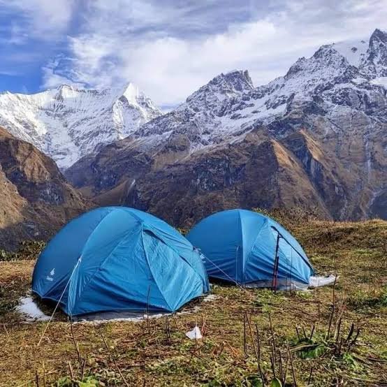
What makes Sunderdhunga Glacier truly special is its raw, untouched beauty and its status as one of the most challenging yet rewarding treks in the Kumaon region. Unlike the more commercialised Pindari and Kafni Glacier treks, Sunderdhunga offers an off-beat experience where you can witness the pristine beauty of the Himalayas in their most authentic form. The valley still harbours two glaciers—Maktoli and Sukhram—and offers breathtaking views of towering peaks including Tharkot (6,100 m), Mrigthuni (6,856 m), and Pwalidwar (6,663 m).
The trek to Sunderdhunga Glacier, which begins from the sacred town of Bageshwar, is a challenging adventure through dense forests of rhododendrons, pines, and cedars, across alpine meadows, and along crystal-clear glacial streams. It is a true test of endurance that rewards trekkers with unparalleled views, a profound sense of accomplishment, and a deep connection with the spiritual heart of the Himalayas.
⚠️ Important Advisory: The Sunderdhunga Glacier trekking route was heavily damaged by the 2013 flash floods and remains largely unrepaired. The trail is considered dangerous at several points, with footbridges washed away and swollen rivers posing serious risks. This guide is provided for informational purposes, and attempting this trek is strongly discouraged without confirmed information about trail restoration and safety.
Key Information at a Glance
History of Sunderdhunga Glacier
The Valley of Beautiful Stones
The history of Sunderdhunga is deeply intertwined with its name. “Sunder Dhunga” means the valley of beautiful stones, a name that likely originated from the ice-crafted boulders left by great glaciers in the past. The valley’s unique geological formations have drawn the attention of explorers, mountaineers, and nature enthusiasts for decades.
Mountaineering Legacy
The Sunderdhunga valley has been a destination for mountaineers seeking to conquer the formidable peaks that surround it. The prominent peaks visible from the glacier—Mrigthuni (6,856 m), Maiktoli (6,803 m), Panwalidwar (6,663 m), and Tharkot (6,100 m)—have attracted climbers from around the world. The valley itself contains two glaciers: Maktoli and Sukhram.
The 2013 Flash Floods and Aftermath
The history of Sunderdhunga as a trekking destination was dramatically altered by the devastating flash floods of June 2013 that struck Uttarakhand.
- The trekking route was heavily damaged by landslides and heavy rainfall
- Footbridges over streams and rivulets were washed away
- The trail has remained neglected and unrepaired for more than a decade
- While the Pindari route received periodic repair work, the Sunderdhunga track remained abandoned
- Crossing the swollen glacial river between Kathalia and Maiktoli base camp is described as “like inviting death”
Recent Controversy (2024)
In 2024, the Sunderdhunga Glacier made national headlines when a self-proclaimed godman, Baba Yogi Chaitanya Akash, constructed an unauthorised shrine at 5,000 metres on the glacier. The temple was built near the sacred Devi Kund, a site visited by pilgrims during the Nanda Raj Yatra every twelve years. Local villagers expressed anger over the encroachment, and a joint team from revenue, forest, and police departments investigated the matter. The illegal temple was subsequently demolished.
Geography of Sunderdhunga Glacier
Location and Topography
Sunderdhunga Glacier is located in the Bageshwar district of Uttarakhand, within the Kumaon Himalayas. It sits on the right side of the Pindar Valley, west of the more famous Pindari Valley.
The Sunderdhunga Valley
The Sunderdhunga valley starts at an elevation of 3,260 metres and extends deep into the Himalayan range. The valley is characterised by:
- Dramatic glacial landforms: moraines, seracs, and icefalls
- Alpine meadows (bugyals) with vibrant seasonal wildflowers
- Crystal-clear glacial streams and cascades carved by meltwater
- Panoramic Himalayan vistas of surrounding high peaks
Surrounding Peaks
From the Sunderdhunga region, trekkers can witness some of the most iconic Himalayan peaks:
| Peak | Elevation |
|---|---|
| Mrigthuni | 6,856 m |
| Maiktoli | 6,803 m |
| Panwalidwar / Pwalidwar | 6,663 m |
| Tharkot | 6,100 m |
| Nanda Devi (East) | Distant view |
Hydrological Significance
Sunderdhunga Glacier feeds seasonal streams that support fragile alpine ecosystems and serve as a water source for downstream communities. The glacier’s meltwater flows into the Sunderdhunga stream, which joins the Pindar River at the village of Warbham. The Pindar River is a major tributary of the Alaknanda River, one of the two headstreams of the Ganges.
Flora and Fauna
Flora
The region surrounding Sunderdhunga Glacier is blessed with rich Himalayan biodiversity.
Forests at Lower Elevations:
- Blood-red rhododendrons that create a spectacular display
- Dense pines and old cedar trees
- Diverse Himalayan forest ecosystems
Alpine Meadows (Bugyals):
- Vibrant seasonal wildflowers in captivating colours
- High-altitude alpine herbs and grazing lands
- The meadows offer a colourful tapestry against the snow-capped peaks
Glacial Zone:
- Alpine vegetation adapted to extreme conditions
Fauna
The area is home to diverse high-altitude Himalayan wildlife:
Mammals:
- Himalayan wildlife including mountain species typical of the western Himalaya
- Seasonal grazers that use the alpine meadows
Birds:
Conservation Status
The region is ecologically sensitive. Trekkers are expected to follow Leave No Trace principles and respect the fragile Himalayan ecosystem. The Uttarakhand Forest Department regulates access to the area.
Religious Beliefs and Significance
The Land of the Gods
The Kumaon Himalayas are deeply revered in Hindu mythology and are often referred to as “Devbhoomi” (Land of the Gods). The peaks surrounding Sunderdhunga—Mrigthuni, Maiktoli, and others—are considered sacred.
The Legend of the Pandavas
According to local legend, the villagers of Khati—the largest village on the route—are believed to be the descendants of the race who provided shelter to the Pandavas during their exile. This connection to the epic Mahabharata adds a profound spiritual dimension to the journey.
The Nanda Raj Yatra
The region holds special significance during the Nanda Raj Yatra, a well-known cultural and religious event in Uttarakhand that takes place every twelve years. Pilgrims undertake an extremely long journey on foot to reach the sacred Devi Kund near the glacier. The most recent Nanda Raj Yatra took place in 2014.
Devi Kund
The sacred kund (lake) near the glacier is a pilgrimage site for locals and devotees. The area is considered religiously significant, and the unauthorised temple built there in 2024 sparked controversy due to its location in an ecologically sensitive and sacred area.
How to Reach Sunderdhunga Glacier
The journey to Sunderdhunga Glacier requires a combination of road travel and trekking.
⚠️ Critical Safety Advisory: The Sunderdhunga Glacier trekking route has been damaged and largely abandoned since the 2013 floods. The information below is provided for historical reference and is not a recommendation to attempt the trek.
By Air
The nearest airport is Pantnagar Airport, approximately 259 km from the trek route.
By Train
The nearest railway station is Kathgodam, approximately 219 km from the trek route. Kathgodam is well-connected to Delhi and other major cities.
Recommended Train:
- Take the Ranikhet Express or other trains from Delhi to Kathgodam
- From Kathgodam, take a cab or bus to Bageshwar (approx. 6-7 hours)
By Road
The Trek Route (Historical)
The trek to Sunderdhunga Glacier shares the initial route with the Pindari and Kafni Glacier treks up to the village of Khati.
⚠️ Important Historical Notes:
- Khati is the largest village on this route
- Beyond Kathalia, there are no permanent settlements
- From Dhungia Dhaun onwards, it is necessary to take a guide even for experienced trekkers
- The glaciers of Maktoli and Sukhram are in opposite directions from Kathalia, 7 km each
Permits Required
- A fores entry permit is required for trekking in the region
- Permits can be obtained from the forest department office in Bageshwar
- All necessary permits are typically arranged by tour operators
Weather and Best Time to Visit
Climate Overview
Sunderdhunga Glacier experiences a high-altitude alpine climate. Days are cool and variable, but nights can drop well below freezing. Rapid weather changes and occasional snowfall are possible outside the core summer months.
Seasonal Breakdown
Best Time to Visit
| Season | Months | Highlights |
|---|---|---|
| Summer | May–June | Pleasant weather, clear trails, blooming wildflowers |
| Autumn | September–October | Post-monsoon clarity, crisp air, golden landscapes |
Note: The trek to Sunderdhunga Glacier was historically open from mid-May to mid-October. However, given the current unsafe conditions, trekking is not recommended at any time of year.
Temperature
| Season | Daytime Temperature | Nighttime Temperature |
|---|---|---|
| Summer (May–June) | 10°C to 20°C | 0°C to 10°C |
| Autumn (Sept–Oct) | 5°C to 15°C | -5°C to 5°C |
| At Glacier | Near freezing or below | Well below freezing |
Nearby Places
Distance from Major Cities
Frequently Asked Questions (FAQs)
General Questions
Q1: What is Sunderdhunga Glacier?
A: Sunderdhunga Glacier is a Himalayan glacier located in the Bageshwar district of Uttarakhand, in the Kumaon Himalayas. The name means “Valley of Beautiful Stones”.
Q2: Where is Sunderdhunga Glacier located?
A: It is located on the right side of the Pindar Valley, approximately 24 kilometres beyond the village of Khati, in the Bageshwar district of Uttarakhand.
Q3: What is the altitude of Sunderdhunga Glacier?
A: The valley starts at 3,260 metres, and the glacier spans elevations from 3,200 metres to 6,050 metres. The maximum trek altitude is approximately 4,320 metres.
Q4: What glaciers are in the Sunderdhunga valley?
A: The valley contains two glaciers: Maktoli Glacier and Sukhram Glacier.
Q5: What peaks can I see from Sunderdhunga?
A: From Sunderdhunga, you can see Tharkot (6,100 m), Mrigthuni (6,856 m), Pwalidwar (6,663 m), and Maiktoli (6,803 m).
Q6: What is the best time to visit Sunderdhunga Glacier?
A: The best time is May to June (summer) and September to October (autumn).
Q7: How long is the trek to Sunderdhunga Glacier?
A: The trek is approximately 45–50 km one way from Loharkhet, taking 7–9 days round trip.
Q8: Is the Sunderdhunga Glacier trek difficult?
A: The trek is considered difficult and strenuous, more challenging than the treks to Pindari and Kafni Glaciers.
Q9: Is the Sunderdhunga Glacier trek currently open?
A: No. The trekking route has been damaged and largely abandoned since the 2013 flash floods, with footbridges washed away and the trail remaining dangerous.
Q10: What wildlife can be found in the area?
A: The region is home to diverse Himalayan wildlife, including alpine herbs, ground-nesting birds, and seasonal grazers.
Q11: What is the nearest town to Sunderdhunga Glacier?
A: Bageshwar is the nearest town, and Khati is the last village on the trek route.
Q12: What is the religious significance of the Sunderdhunga region?
A: The region is sacred to Hindus, with the Devi Kund being a pilgrimage site visited during the Nanda Raj Yatra every twelve years.
Q13: What is the distance from Delhi to Bageshwar?
A: The distance is approximately 350 km by road.
Q14: What should I pack for the Sunderdhunga Glacier trek?
A: Pack layered trekking clothing, waterproof outer shell, warm insulated jacket, sturdy hiking boots, gaiters, trekking poles, sun protection, headlamp, and a warm sleeping bag rated for freezing temperatures.
Q15: How many days are required for the Sunderdhunga Glacier trek?
A: The trek typically takes 7 to 9 days to complete.
Q16: Why is the Sunderdhunga Glacier trek abandoned?
A: The trail was heavily damaged by the 2013 floods, and bridges and other infrastructure remain broken. The route has been neglected while other treks like Pindari received repairs.
Q17: What is the Nanda Raj Yatra?
A: The Nanda Raj Yatra is a well-known cultural and religious event in Uttarakhand that takes place every twelve years, with pilgrims walking long distances to reach sacred sites like Devi Kund.
Q18: What happened at Sunderdhunga Glacier in 2024?
A: In 2024, a self-proclaimed godman built an unauthorised temple at 5,000 metres on the glacier, which was subsequently demolished by authorities.
Q19: Can I camp at Sunderdhunga Glacier?
A: Camping was historically permitted at designated sites like Kathalia and Dhungia Dhaun.
Q20: Is the trek suitable for beginners?
A: No. This trek is recommended only for experienced trekkers with excellent physical fitness and prior high-altitude trekking experience.
Essential Tips for Trekkers
⚠️ Critical Safety Advisory: The Sunderdhunga Glacier trekking route has been damaged and largely abandoned since the 2013 flash floods. The following tips are provided for historical context and general high-altitude trekking awareness. Attempting this trek is strongly discouraged without confirmed information about trail restoration and safety.
- Check Current Conditions: Before considering any trek, verify the current status of the trail with local authorities in Bageshwar
- Hire a Guide: From Dhungia Dhaun onwards, it is necessary to take a guide even for experienced trekkers
- Physical Fitness: The trek requires excellent physical fitness and stamina
- Permits: Obtain all necessary permits from the forest department well in advance
- Gear: Carry proper high-altitude trekking gear including warm clothing, sturdy boots, and camping equipment
- Weather: Check weather forecasts before starting the trek
- Hydration: Stay well-hydrated; carry water purification tablets
- Leave No Trace: Respect the fragile Himalayan ecosystem
- Insurance: Consider travel insurance covering high-altitude trekking
- Inform Family: Let someone know your trek itinerary as there is limited or no mobile signal on the trail
Plan Your Kumaon Adventure with Discover Uttarakhand
At Discover Uttarakhand, we’ve been organising unforgettable Himalayan journeys since 1997. As a trusted local operator with deep knowledge of the Kumaon region, we offer:
✅ Customised trekking packages in the Kumaon region
✅ Combined itineraries with Pindari Glacier and other nearby attractions
✅ Experienced local guides and porters
✅ Comfortable transport with experienced hill drivers
✅ All necessary permits and arrangements
✅ Quality camping equipment and nutritious meals
✅ 24/7 customer support throughout your journey
Recommended Alternatives to Sunderdhunga Glacier
Given the current unsafe conditions of the Sunderdhunga Glacier trek, we recommend the following alternative treks in the Kumaon region:
| Package | Duration | Starting Point | Highlights |
|---|---|---|---|
| Pindari Glacier Trek | 7 Days / 6 Nights | Kathgodam | Most popular glacier trek of Kumaon |
| Kafni Glacier Trek | 7 Days / 6 Nights | Kathgodam | Less-crowded alternative |
| Kumaon Himalayan Trek | 5 Days / 4 Nights | Kathgodam | Scenic villages, alpine meadows |
📞 Call / WhatsApp: +91-9997187178, 9760222178, 8171977178
📍 Visit Our Office: Himalayan Colony, opposite DSVV, Haripur Kalan, Haridwar, Motichur Range, Uttarakhand 249411
🌐 Website: www.discover-uttarakhand.com
📧 Email: info@discover-uttarakhand.com
While the Sunderdhunga Glacier trek remains closed, the Kumaon Himalayas offer many other breathtaking journeys. Plan your expedition with proper preparation and respect for the magnificent Himalayan wilderness.
Discover Uttarakhand – Your Local Partner for Unforgettable Himalayan Journeys Since 1997 🏔️